South Hill, Washington facts for kids
Quick facts for kids
South Hill, Washington
|
|
|---|---|
| Nickname(s):
South Puyallup
|
|

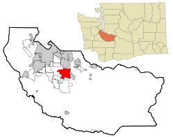
Location of South Hill, Washington
|
|
| Country | United States |
| State | Washington |
| County | Pierce |
| Area | |
| • Total | 18.1 sq mi (46.8 km2) |
| • Land | 18.0 sq mi (46.6 km2) |
| • Water | 0.1 sq mi (0.2 km2) |
| Elevation | 535 ft (163 m) |
| Population
(2020)
|
|
| • Total | 64,708 |
| • Density | 3,575/sq mi (1,382.6/km2) |
| Time zone | UTC-8 (Pacific (PST)) |
| • Summer (DST) | UTC-7 (PDT) |
| ZIP codes |
98373-98375
|
| Area code | 253 & 360 |
| FIPS code | 53-65922 |
| GNIS feature ID | 1867636 |
South Hill is a busy community in Pierce County, Washington. It's located just south of a city called Puyallup. South Hill is known as a census-designated place (CDP). This means it's an area that looks like a town but isn't officially a city with its own local government.
In 2020, about 64,708 people lived in South Hill. This was a big jump from 52,431 people in 2010! The area is mostly made up of suburban homes, neighborhoods, and apartment buildings. You'll also find many shopping centers here. Because South Hill isn't an official city, its mailing addresses use the Puyallup "postal city" or ZCTA.
The main road for shopping and businesses is Meridian Avenue, also known as State Route 161. Some well-known neighborhoods include Manorwood, Sunrise, Lipoma Firs, Silvercreek, and Gem Heights. There are also fun public parks like Bradley Lake Park, South Hill Community Park, and Wildwood Park.
People first started settling in this area in the 1880s. This happened after a military road was built through the region in the 1850s. At first, there were logging camps, farms, and hunting spots. South Hill was also the main path to towns like Kapowsin and Eatonville. The number of people living here grew slowly until after World War II. After the war, roads got better, making it easier for people to travel to nearby Tacoma, Fort Lewis, and Seattle for work.
Contents
Exploring South Hill's Location and Landscape
South Hill is located at 47°7′16″N 122°17′26″W / 47.12111°N 122.29056°W. Its name, "South Hill," perfectly describes where it is. It sits high up on the south side of the Puyallup River valley. This is different from nearby areas like Edgewood and Milton, which people sometimes call "North Hill."
The community covers about 18.1 square miles (46.8 square kilometers). Most of this area, about 18.0 square miles (46.6 square kilometers), is land. A small part, about 0.1 square miles (0.2 square kilometers), is water.
What's the Weather Like in South Hill?
South Hill has a climate typical of the Pacific Northwest. It generally has mild temperatures. Winters are cool and wet, while summers are warm and drier.
| Climate data for McMillin Reservoir, Washington, 1991–2020 normals, extremes 1941–present | |||||||||||||
|---|---|---|---|---|---|---|---|---|---|---|---|---|---|
| Month | Jan | Feb | Mar | Apr | May | Jun | Jul | Aug | Sep | Oct | Nov | Dec | Year |
| Record high °F (°C) | 66 (19) |
67 (19) |
79 (26) |
84 (29) |
92 (33) |
99 (37) |
102 (39) |
100 (38) |
95 (35) |
86 (30) |
73 (23) |
66 (19) |
102 (39) |
| Mean maximum °F (°C) | 57.5 (14.2) |
58.3 (14.6) |
65.3 (18.5) |
72.8 (22.7) |
81.0 (27.2) |
84.3 (29.1) |
89.8 (32.1) |
88.8 (31.6) |
81.8 (27.7) |
71.6 (22.0) |
61.5 (16.4) |
57.1 (13.9) |
92.1 (33.4) |
| Mean daily maximum °F (°C) | 46.1 (7.8) |
48.0 (8.9) |
52.4 (11.3) |
57.3 (14.1) |
64.3 (17.9) |
69.0 (20.6) |
75.7 (24.3) |
76.5 (24.7) |
69.6 (20.9) |
59.1 (15.1) |
50.3 (10.2) |
45.0 (7.2) |
59.4 (15.2) |
| Daily mean °F (°C) | 39.7 (4.3) |
40.6 (4.8) |
44.0 (6.7) |
48.0 (8.9) |
54.4 (12.4) |
59.0 (15.0) |
64.0 (17.8) |
64.5 (18.1) |
58.9 (14.9) |
50.4 (10.2) |
43.2 (6.2) |
39.0 (3.9) |
50.5 (10.3) |
| Mean daily minimum °F (°C) | 33.3 (0.7) |
33.1 (0.6) |
35.7 (2.1) |
38.7 (3.7) |
44.5 (6.9) |
49.0 (9.4) |
52.4 (11.3) |
52.6 (11.4) |
48.2 (9.0) |
41.7 (5.4) |
36.1 (2.3) |
32.9 (0.5) |
41.5 (5.3) |
| Mean minimum °F (°C) | 22.5 (−5.3) |
22.9 (−5.1) |
27.2 (−2.7) |
30.7 (−0.7) |
36.0 (2.2) |
42.5 (5.8) |
45.9 (7.7) |
46.0 (7.8) |
39.7 (4.3) |
31.2 (−0.4) |
24.7 (−4.1) |
21.7 (−5.7) |
17.3 (−8.2) |
| Record low °F (°C) | 0 (−18) |
3 (−16) |
9 (−13) |
23 (−5) |
26 (−3) |
32 (0) |
36 (2) |
37 (3) |
29 (−2) |
21 (−6) |
0 (−18) |
−1 (−18) |
−1 (−18) |
| Average precipitation inches (mm) | 6.12 (155) |
4.33 (110) |
4.80 (122) |
3.90 (99) |
2.97 (75) |
2.28 (58) |
0.92 (23) |
0.90 (23) |
1.78 (45) |
4.08 (104) |
7.06 (179) |
5.99 (152) |
45.13 (1,146) |
| Average snowfall inches (cm) | 1.5 (3.8) |
0.5 (1.3) |
0.6 (1.5) |
0.0 (0.0) |
0.0 (0.0) |
0.0 (0.0) |
0.0 (0.0) |
0.0 (0.0) |
0.0 (0.0) |
0.0 (0.0) |
1.5 (3.8) |
1.5 (3.8) |
5.6 (14) |
| Average precipitation days (≥ 0.01 in) | 20.0 | 15.2 | 19.6 | 16.3 | 13.1 | 10.5 | 5.0 | 4.5 | 7.9 | 14.6 | 19.4 | 20.2 | 166.3 |
| Average snowy days (≥ 0.1 in) | 1.0 | 0.4 | 0.5 | 0.0 | 0.0 | 0.0 | 0.0 | 0.0 | 0.0 | 0.0 | 0.5 | 1.1 | 3.5 |
| Source: NOAA | |||||||||||||
Who Lives in South Hill?
The number of people living in South Hill has grown a lot over the years.
| Historical population | |||
|---|---|---|---|
| Census | Pop. | %± | |
| 1980 | 7,035 | — | |
| 1990 | 12,963 | 84.3% | |
| 2000 | 31,623 | 143.9% | |
| 2010 | 52,431 | 65.8% | |
| 2020 | 64,708 | 23.4% | |
| U.S. Decennial Census | |||
In 2000, there were 31,623 people living in South Hill. About 10,929 households and 8,721 families were counted. The population density was about 1,756 people per square mile. Most people (87.41%) were White. Other groups included African American, Native American, Asian, and Pacific Islander residents. About 4.13% of the population was Hispanic or Latino.
Many households (45.7%) had children under 18 living with them. Most families (65.3%) were married couples. The average household had 2.89 people, and the average family had 3.20 people. The median age was 33 years old. This means half the people were younger than 33 and half were older.
By 2010, the population had grown to 52,431 people. There were 17,962 households and 13,990 families. The racial makeup shifted a bit, with 78.2% White residents. Asian residents made up 6.0%, and Hispanic or Latino residents were 8.5% of the population. The median age was 33.6 years.
Schools and Learning in South Hill
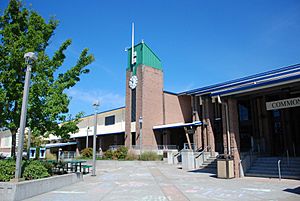
The Puyallup School District serves all the public schools in South Hill. There are two high schools right in South Hill: Governor John R. Rogers High School and Emerald Ridge High School.
South Hill also has three junior high schools:
- Glacier View Junior High
- Stahl Junior High
- Ballou Junior High
And many elementary schools, including:
- Hunt Elementary
- Edgerton Elementary
- Carson Elementary
- Pope Elementary
- Brouillet Elementary
- Firgrove Elementary
- Zeiger Elementary
- Ridgecrest Elementary
- Dessie F. Evans Elementary
A Look Back: South Hill's History
The South Hill Historical Society works to collect information and memories about the area's past.
Important Moments in South Hill's Past
- 1853: The Longmire-Biles wagon train traveled through South Hill.
- 1870: People began living in South Hill.
- 1895: The Firgrove School District was created.
- 1905: The main road through South Hill was named Ball-Wood Road.
- 1909: The Tacoma-Puyallup Interurban Line rail started running through South Hill.
- 1930: The SagMiller Airstrip opened.
- 1944: Thun Field opened. This airport is known today as Pierce County Airport.
- 1945: During World War II, Japan sent balloon bombs to the mainland USA. Two of these bombs landed in South Hill.
- 1950: The Firgrove School District joined with the Puyallup School District.
- 1972: State Route 512 was finished.
- 1998: Voters decided against a plan for South Hill to become its own city called Southview.
Parks and Outdoor Fun in South Hill
South Hill has three main parks. These parks are managed by Pierce County.
- Heritage Recreation Center: This is a large 40-acre sports complex. It has fields for baseball, soccer, and other sports. You can find it between Rogers High School and Zeiger Elementary School.
- South Hill Community Park: This 40-acre park offers a playground and two soccer fields. It's also home to the South Hill Loop Trail and the Nathan Chapman Memorial Trail. The Nathan Chapman Memorial Trail is a 1.6-mile paved path. It goes through forests and wetlands, connecting the park to the Heritage Recreation Center. This trail is named after Sgt. Nathan Chapman. He was a South Hill resident and the first American soldier to die in the war in Afghanistan.
- Meridian Habitat Park & Community Center: This 36-acre park is located on State Route 161. Years ago, it was an outdoor theater owned by Champion Center Church. The church sold the property to Pierce County in 2006.
You can also find Bradley Lake Park and Wildwood Park nearby. These parks are actually within the city limits of Puyallup.
Neighboring Communities Around South Hill
 |
Summit | Puyallup | Alderton |  |
| Frederickson | Prairie ridge | |||
| Elk Plain | Graham | Orting |
Famous People From South Hill
Some notable people have connections to South Hill:
- Sgt. Nathan Chapman - He was the first American soldier to die in the war in Afghanistan.
- Megan Jendrick - An Olympic swimmer who won two gold medals.
- Melanie Stambaugh - She was elected to the Washington state House of Representatives in 2014.
- Brandon Gibson - A graduate of Rogers High School, he was a talented football and basketball player at Washington State University. He was drafted into the 2009 NFL Draft.
See also
 In Spanish: South Hill (Washington) para niños
 | Percy Lavon Julian |
 | Katherine Johnson |
 | George Washington Carver |
 | Annie Easley |


