South Thomaston, Maine facts for kids
Quick facts for kids
South Thomaston, Maine
|
|
|---|---|

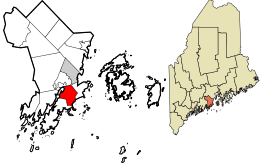
Location in Knox County and the state of Maine.
|
|
| Country | United States |
| State | Maine |
| County | Knox |
| Incorporated | 1848 |
| Villages | South Thomaston Pleasant Beach Spruce Head Waterman Beach |
| Area | |
| • Total | 17.97 sq mi (46.54 km2) |
| • Land | 11.44 sq mi (29.63 km2) |
| • Water | 6.53 sq mi (16.91 km2) |
| Elevation | 49 ft (15 m) |
| Population
(2020)
|
|
| • Total | 1,511 |
| • Density | 132/sq mi (51.0/km2) |
| Time zone | UTC-5 (Eastern (EST)) |
| • Summer (DST) | UTC-4 (EDT) |
| ZIP code |
04858
|
| Area code(s) | 207 |
| FIPS code | 23-72585 |
| GNIS feature ID | 0582739 |
South Thomaston is a small town in Knox County, Maine, United States. It's known for its fishing and as a nice place to visit. In 2020, about 1,511 people lived here. The town includes the village of Spruce Head.
Contents
History of South Thomaston
The Native American people called Abenaki Indians lived here first. They named the area Wessaweskeag. This name means "tidal creek" or "salt creek." It refers to the Weskeag River we know today.
In 1704, a man named Thomas Lefebvre from Quebec, Canada, owned a large piece of land by the Weskeag River. He built a big gristmill (a mill for grinding grain) and a house. Even though he later went back to Quebec, people still called the area "Thomas' Town."
However, there were conflicts between New England and New France. These were called the French and Indian Wars. Because of these wars, people couldn't settle permanently in the area for a while. The wars ended in 1763 with the Treaty of Paris.
In 1767, Elisha Snow became one of the first permanent settlers in Wessaweskeag. He built a sawmill that used the power of the tides. In 1773, Joseph Coombs arrived and built another sawmill nearby. Together, they also built a gristmill.
The village of South Thomaston grew around these mills. It also had machines to polish granite from the many quarries in town. On July 28, 1848, South Thomaston officially became its own town. Before that, it was part of Thomaston. Later, on July 9, 1921, Owl's Head became a separate town from South Thomaston.
A local family, Joseph and Flora Baum, owned and ran Baum's Market. This store is now known as the Keag Store. Flora Baum was even the Postmistress, chosen by President Woodrow Wilson. Their son, Joseph Baum, Jr. (Bud), served on the town's Board of Selectmen and was the Fire Chief for many years.
Gilford Butler was a local lawyer and led the school board. He and his sister Lula Butler lived in what is now the Geag Inn. Gilford left a lot of his money to the town. He wanted them to build a new elementary school, and he asked that the school be named after him.
Geography of South Thomaston
South Thomaston covers about 17.97 square miles (46.54 km2) in total. About 11.44 square miles (29.63 km2) of this is land, and 6.53 square miles (16.91 km2) is water. The town is located right on the inlet of the Weskeag River.
Population and People
| Historical population | |||
|---|---|---|---|
| Census | Pop. | %± | |
| 1850 | 1,420 | — | |
| 1860 | 1,615 | 13.7% | |
| 1870 | 1,693 | 4.8% | |
| 1880 | 1,771 | 4.6% | |
| 1890 | 1,534 | −13.4% | |
| 1900 | 1,426 | −7.0% | |
| 1910 | 1,438 | 0.8% | |
| 1920 | 947 | −34.1% | |
| 1930 | 579 | −38.9% | |
| 1940 | 538 | −7.1% | |
| 1950 | 654 | 21.6% | |
| 1960 | 732 | 11.9% | |
| 1970 | 831 | 13.5% | |
| 1980 | 1,064 | 28.0% | |
| 1990 | 1,227 | 15.3% | |
| 2000 | 1,416 | 15.4% | |
| 2010 | 1,558 | 10.0% | |
| 2020 | 1,511 | −3.0% | |
| U.S. Decennial Census | |||
In 2020, the town had 1,511 residents. According to the 2010 census, there were 1,558 people living in South Thomaston. The average age of people in the town was about 47 years old. About 19.6% of residents were under 18 years old, and 20.5% were 65 or older.
Most households were families, with many being married couples. The town's unemployment rate was low, at 2.9% in 2010.
Places to Visit
- Wessaweskeag Historical Society
See also
 In Spanish: South Thomaston para niños

