South West Delhi district facts for kids
Quick facts for kids
South West Delhi
|
|
|---|---|
| Country | |
| State | Delhi |
| Created | 1997 |
| Headquarters | Kapashera |
| Government | |
| • Body | Municipal Corporation Of Delhi |
| Population
(2011)
|
|
| • Total | 2,292,958 |
| Languages | |
| • Official | Hindi, Punjabi, English. |
| Time zone | UTC+5:30 (IST) |
| PIN |
1100xx
|
| Lok Sabha constituencies | West Delhi, South Delhi |
| Civic agency | Municipal Corporation Of Delhi |
| Website | https://dmsouthwest.delhi.gov.in/ |
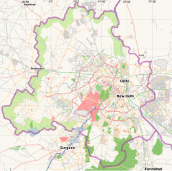
South West Delhi is one of the eleven main administrative areas, called districts, in the National Capital Territory of Delhi in India. An administrative district is like a large region managed by a local government. Kapashera is the main office location for South West Delhi's administration.
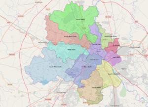
This district is surrounded by other areas. To the north, it borders West Delhi. To the northeast, you'll find Central Delhi. New Delhi and South Delhi are to its east. The Gurgaon District in Haryana state is to the south, and the Jhajjar District, also in Haryana, is to the west.
South West Delhi had a population of 2,292,958 people in 2011. It covers an area of 420 square kilometers. This means about 5,445 people live in each square kilometer. It is the fourth most populated district in Delhi.
The district court for South West Delhi, which works under the Delhi High Court, is located in Dwarka Sector 10. This court helps solve legal issues for the people living in the district.
For easier management, the district is split into three smaller areas called subdivisions. These are Dwarka, Najafgarh, and Kapashera.
History of South West Delhi
South West Delhi is one of the older districts in the region. It was created in January 1997. When it first started, the district included five subdivisions: Vasant Vihar, JanakPuri, Najafgarh, Kapashera, and Delhi Cantonment. Its main office was located in Palam.
Geography and Landscape
The South West District of Delhi is located in the southwestern part of the National Capital Territory. Its location is between 28 degrees 40 minutes and 28 degrees 29 minutes latitude, and between 76 degrees 50 minutes and 77 degrees 14 minutes longitude.
The district has different types of areas. The Kapashera Subdivision is mostly rural, meaning it has more villages and open land. The Dwarka Subdivision is mostly urban, with many buildings and city life. The Najafgarh Subdivision is a mix of both city and rural areas.
Population and People
| Historical population | ||
|---|---|---|
| Year | Pop. | ±% p.a. |
| 1961 | 251,383 | — |
| 1971 | 479,189 | +6.66% |
| 1981 | 679,170 | +3.55% |
| 1991 | 1,087,573 | +4.82% |
| 2001 | 1,755,041 | +4.90% |
| 2011 | 2,292,958 | +2.71% |
| source: | ||
Based on the 2011 census, South West Delhi has a total population of 2,292,958 people. This number is similar to the population of the country of Latvia or the US state of New Mexico.
This population size ranks South West Delhi as the 198th most populated district in India, out of 640 districts. The district has a population density of about 5,445 people per square kilometer. Between 2001 and 2011, the population grew by 30.62%.
In terms of sex ratio, there are 836 females for every 1000 males in South West Delhi. The literacy rate, which is the percentage of people who can read and write, is 88.81%.
See also
 In Spanish: Distrito de Delhi sudoeste para niños
- Asalat Pur Khawad
- Districts of Delhi
- Kapashera
- Nangal Dewat
 | Chris Smalls |
 | Fred Hampton |
 | Ralph Abernathy |


