Spring Creek Pass facts for kids
Quick facts for kids Spring Creek Pass |
|
|---|---|

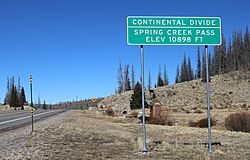
Looking north across the pass.
|
|
| Elevation | 10,889 ft (3,319 m) |
| Traversed by | SH 149 |
| Location | Hinsdale County, Colorado, U.S. |
| Range | San Juan Mountains |
| Coordinates | 37°56′27″N 107°09′33″W / 37.94083°N 107.15917°W |
| Topo map | USGS Slumgullion Pass |
Spring Creek Pass is a high mountain pass in the San Juan Mountains of Colorado. It sits at an elevation of 10,889 ft (3,319 m), which is about 3,319 meters above sea level. This pass is special because it crosses the Continental Divide. The Continental Divide is like a giant line across North and South America. It separates the rivers that flow to the Pacific Ocean from those that flow to the Atlantic Ocean.
You can travel over Spring Creek Pass using State Highway 149. The famous Colorado Trail also goes through this pass. Interestingly, Spring Creek Pass is not the highest point on Highway 149 in this area. If you drive north from the pass, the road climbs even higher over a place called Slumgullion Summit. After that, the road goes downhill towards Lake City.
Moving Water Around
Around the year 1910, a special channel called the Tabor Ditch was built near Spring Creek Pass. A "ditch" is like a small canal. Its purpose was to move water from one place to another. This process is called water diversion.
Why the Ditch Was Built
The Tabor Ditch was designed to take water from streams that feed into Cebolla Creek. These streams are part of the Gunnison River basin. A "river basin" is the area of land where all the water drains into a specific river. The ditch carried this water over the Continental Divide at Spring Creek Pass. From there, the water flowed into Big Spring Creek, which is part of the Rio Grande basin.
How the Ditch Is Used Today
The Tabor Ditch is about 0.5 miles (0.8 kilometers) long. It was first built to help farmers water their crops. This is called "irrigation." Today, the ditch is owned by Colorado Parks and Wildlife. It can carry a lot of water, about 30 cubic feet per second (0.85 cubic meters per second). In an average year, it moves about 1,400 acre-feet of water. An "acre-foot" is a way to measure a large amount of water. It's enough water to cover one acre of land with one foot of water. This is about 1.7 million cubic meters of water!
 | George Robert Carruthers |
 | Patricia Bath |
 | Jan Ernst Matzeliger |
 | Alexander Miles |


