Sri Jayawardenepura Kotte facts for kids
Quick facts for kids
Sri Jayawardenepura Kotte
ශ්රී ජයවර්ධනපුර කෝට්ටේ
ஶ்ரீ ஜெயவர்த்தனபுர கோட்டை |
|
|---|---|
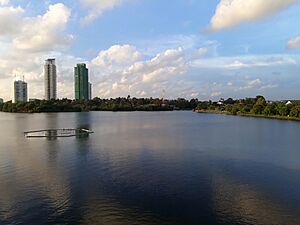
View from Diyawanna Lake
|
|
| Country | Sri Lanka |
| Province | Western Province |
| District | Colombo District |
| Area | |
| • Administrative Capital | 17 km2 (7 sq mi) |
| Population
(2001)
|
|
| • Administrative Capital | 115,826 |
| • Density | 3,305/km2 (8,560/sq mi) |
| • Metro | 2,234,289 |
| Time zone | UTC+5:30 (SLST) |
| Postal code |
10100
|
| Area code(s) | 011 |
Sri Jayawardenepura Kotte, often called Kotte, is the legislative capital of Sri Lanka. This means it's where the country's main law-making body, the Parliament, is located. It sits right next to Colombo, which is Sri Lanka's largest city and its economic hub.
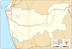
The area of Sri Jayawardenepura Kotte is surrounded by several other towns and councils. These include Kolonnawa to the north and Colombo to the west.
Contents
A Look Back in Time: Kotte's History
Long ago, in the 13th century, there was a village called Darugama. It was a very safe place because it was located where two streams met. A local leader named Nissanka Alagakkonara decided to build a Kotte, which means a fortress, here. This made the area even more secure.
Alagakkonara was a powerful figure. He stopped an enemy army from entering Kotte. He also defeated their ships in a battle at Panadura.
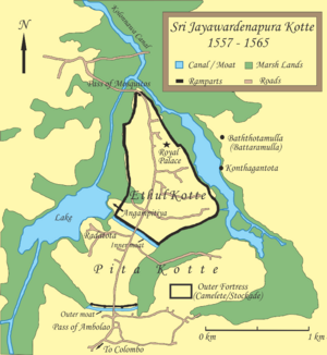
Kotte was a special kind of fortress called a jala durgha, or "water fortress." It was shaped like a triangle. Two sides were protected by the Diyawanna Oya and Kolonnawa Oya marshes. The third side, which was on land, had a large moat dug to protect it. The fortress was about 2.5 square kilometers in size. It had strong walls made of kabook (a type of rock) that were 2.5 meters high and 10.7 meters wide.
In 1391, after Prince Sapumal conquered the Jaffna Kingdom, Kotte was given a new name: 'Sri Jayawardenepura'. This means "resplendent city of growing victory." It became the capital of the ancient Kingdom of Kotte and remained so until the late 1500s.
The buildings in Kotte, including the king's palace, were made from laterite and clay. You can still see where some of these laterite blocks were dug out at Ananda Sastralaya, Kotte, a local school.
The capital city had many important features:
- The king's palace had walls that sparkled like moonlight and a golden spire. It also had beautiful gardens and springs.
- The Dalada Maligawa, a three-story temple, held the sacred tooth relic of Buddha.
- The "Arama" was a five-story building where sixty Buddhist monks lived.
- The king's treasure house kept all the royal riches.
- The 'Kotavehara' was the only Buddhist temple outside the city's main defenses.
- The royal cemetery was at Beddagana.
- The 'Angampitiya' was a special ground for military training and parades.
The Portuguese arrived in Sri Lanka in 1505. At first, the king welcomed them. However, the Portuguese wanted to control the city and its trade. By 1565, they had taken over Kotte. But they couldn't defend it from attacks by the nearby kingdom of Sitawaka. So, the Portuguese left Kotte and made Colombo their new capital.
Like many old cities, Sri Jayawardenepura was built to be very secure. Its walls and moat protected the entire city. You can still see parts of these old defenses today. Sadly, some people have built houses and garages on top of the old walls.
In the 1800s, Kotte started to grow again. But many of its old ruins were taken apart and used to build new structures. Some of these ancient stones even ended up in the Victoria Bridge over the Kelani River.
How the Government Works: Legislature
The new Parliament building was opened on April 29, 1982. It was built on land that was created by draining marshy areas around the Diyawanna Oya lake. The new Parliament sits on Duwa, an island in the middle of the lake. This island was once a recreation spot for Portuguese soldiers.
The government is still in the process of moving more of its offices from Colombo to Sri Jayawardenepura Kotte.
Running the City: Municipal Structure
The Kotte Urban Development Council was formed in the 1930s. Later, it became the Kotte Urban Council. In 1997, it was renamed the Sri Jayawardenepura Kotte Municipal Council. Chandra Silva was the first Mayor of this new council.
The Municipal Council has 20 members. These members are elected by the people to represent them.
Main Areas of Kotte
The city is divided into several important areas, including:
- Pita Kotte
- Ethul Kotte
- Nawala
- Nugegoda
- Rajagiriya
People and Cultures: Demographics
Sri Jayawardenepura Kotte is a city with many different ethnic groups and religions. This makes it a diverse and interesting place.
According to the 2012 census, most people in Kotte are Sinhalese. There are also significant numbers of Sri Lankan Tamils and Sri Lankan Moors.
When it comes to religion, most people in Kotte practice Buddhism. Other religions practiced include Roman Catholicism, Islam, and Hinduism.
Getting Around and Learning: Infrastructure
Transport
The main railway station in Kotte is at Nugegoda, which is part of the Kelani Valley Line. Nugegoda also has the main bus station. There are other bus stops in Pita Kotte. The city has a good bus service, including a large bus depot at Udahamulla.
In 2005, a passenger boat service was planned. It would travel between Parliament Junction in Battaramulla and the Wellawatte canal. This boat trip would take about 30 minutes. It was designed to have stops at places like the Kotte Marsh, Nawala, and the Open University.
Education
Kotte has many schools, both public and private. Some are "national schools" run by the central government, like President's College, Sri Jayawardenepura Kotte. Others are "government schools" run by local councils. There are also private and international schools, such as Gateway College Colombo.
The oldest English school in Sri Lanka, Sri Jayawardenepura Maha Vidyalaya, is located in Pita Kotte. Ananda Sastralaya in Pita Kotte is the oldest Buddhist school in the city. Anula Vidyalaya in Nugegoda is one of the largest Buddhist girls' schools in South Asia, with over 5,000 students.
The Education Ministry and the Department of Examinations are both located in Kotte.
Many students living in Kotte also attend colleges and international schools in Colombo.
Kotte is home to the Open University, Sri Lanka in Nawala and the University of Sri Jayewardenepura in Nugegoda. There are also public Libraries in Nugegoda and Rajagiriya.
Weather in Kotte: Climate
Sri Jayawardenepura Kotte has a tropical rainforest climate. This means it's warm all year round with lots of rain. The temperatures don't change much throughout the year. February is usually the driest month, but it still gets a good amount of rain. Because it rains so much, Kotte is classified as a tropical rainforest climate.
| Climate data for Sri Jayawardenepura Kotte | |||||||||||||
|---|---|---|---|---|---|---|---|---|---|---|---|---|---|
| Month | Jan | Feb | Mar | Apr | May | Jun | Jul | Aug | Sep | Oct | Nov | Dec | Year |
| Mean daily maximum °C (°F) | 30.6 (87.1) |
31.2 (88.2) |
31.7 (89.1) |
31.8 (89.2) |
31.1 (88.0) |
30.4 (86.7) |
30.0 (86.0) |
30.0 (86.0) |
30.3 (86.5) |
30.0 (86.0) |
30.2 (86.4) |
30.4 (86.7) |
30.6 (87.2) |
| Daily mean °C (°F) | 26.6 (79.9) |
26.9 (80.4) |
27.7 (81.9) |
28.2 (82.8) |
28.3 (82.9) |
27.9 (82.2) |
27.5 (81.5) |
27.6 (81.7) |
27.5 (81.5) |
27.0 (80.6) |
26.7 (80.1) |
26.6 (79.9) |
27.4 (81.3) |
| Mean daily minimum °C (°F) | 22.3 (72.1) |
22.7 (72.9) |
23.7 (74.7) |
24.6 (76.3) |
25.5 (77.9) |
25.5 (77.9) |
25.1 (77.2) |
25.2 (77.4) |
24.8 (76.6) |
24.0 (75.2) |
23.2 (73.8) |
22.8 (73.0) |
24.1 (75.4) |
| Average precipitation mm (inches) | 85 (3.3) |
63 (2.5) |
112 (4.4) |
252 (9.9) |
335 (13.2) |
195 (7.7) |
130 (5.1) |
95 (3.7) |
165 (6.5) |
358 (14.1) |
309 (12.2) |
153 (6.0) |
2,251 (88.6) |
| Source 1: Free Meteo (1961–1990) | |||||||||||||
| Source 2: Weatherbase for precipitation | |||||||||||||
Fun and Games: Sports and Recreation
Cricket is the most popular sport in Kotte and across Sri Lanka. You'll often see games being played in the city's grounds.
Association football (soccer) was once very popular in the Colombo area. Although cricket became more popular after 1980, football is growing again. The city once had four football clubs that used the EW Perera Park grounds. However, these grounds were later destroyed.
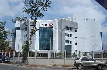
In the 1990s, the Kotte Municipal Council built the Chandra Silva Stadium to replace the old grounds. Part of this land was sold to build the HSBC building. In 2007, a new Chandra Silva Stadium was started on a former rubbish dump behind the HSBC building.
Football has become popular again in Kotte. The football association has a new training facility in the city. It has a football field with a sprinkler system, a gym, and other great facilities. This helps to train and develop talented players.
Other sports are played at various clubs and gyms. These include tennis, squash, billiards, horse riding, indoor cricket, badminton, and table tennis. If you like horse riding, you can go to the Premadasa Riding School in Nugegoda.
Famous People from Kotte
- E. W. Perera (1875–1953): A famous Sri Lankan lawyer, politician, and freedom fighter.
- Sir James Peter Obeyesekere II (1879–1968): An important colonial-era headman and aide to the British Governor of Ceylon.
- Tissa Abeysekara (1939–2009): A well-known film personality.
See also
 In Spanish: Sri Jayawardenapura Kotte para niños
 | May Edward Chinn |
 | Rebecca Cole |
 | Alexa Canady |
 | Dorothy Lavinia Brown |


