St. Anthony, Idaho facts for kids
Quick facts for kids
St. Anthony, Idaho
|
|
|---|---|

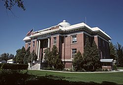
Fremont County Courthouse in St. Anthony
|
|

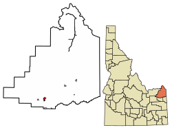
Location of St. Anthony in Fremont County, Idaho.
|
|
| Country | United States |
| State | Idaho |
| County | Fremont |
| Area | |
| • Total | 1.59 sq mi (4.11 km2) |
| • Land | 1.55 sq mi (4.01 km2) |
| • Water | 0.04 sq mi (0.11 km2) |
| Elevation | 4,964 ft (1,513 m) |
| Population
(2010)
|
|
| • Total | 3,542 |
| • Estimate
(2019)
|
3,553 |
| • Density | 2,298.19/sq mi (887.11/km2) |
| Time zone | UTC-7 (Mountain (MST)) |
| • Summer (DST) | UTC-6 (MDT) |
| ZIP Code |
83445
|
| Area code(s) | 208 |
| FIPS code | 16-71020 |
| GNIS feature ID | 2411755 |
St. Anthony is a city in Idaho, United States. It is the main city and county seat of Fremont County. In 2010, about 3,542 people lived there. This was more than the 3,342 people counted in 2000. St. Anthony is part of the Rexburg, Idaho area.
Contents
History of St. Anthony
Before St. Anthony was officially founded, a fur trader named Major Andrew Henry set up a temporary fort nearby. This fort was used in 1811. Henry's name lives on in the Henrys Fork of the Snake River, which flows through St. Anthony.
The exact start date of St. Anthony is debated. Some say it was founded in 1888 by members of the Church of Jesus Christ of Latter-day Saints. Others believe it started in 1890. Around the same time, a bridge was built over the Henrys Fork where the city is today. The city got its name from Saint Anthony Falls in Minnesota.
The railroad reached St. Anthony in 1899, making it easier for people and goods to travel. The first post office opened in 1901. Charles C. Moore arrived on the first train. He was a teacher and later served as postmaster. He became the governor of Idaho in 1922 and lived to be 92 years old in St. Anthony.
In the early days, businesses in St. Anthony would close on Wednesday afternoons. This was so people could rest and the city's baseball team could play against teams from other towns.
A major church building, called the Yellowstone Tabernacle, was built in 1912. It cost a lot of money back then. The first county courthouse was built in 1909. The first movie theater opened in 1911, showing silent films. By 1928, St. Anthony had two movie theaters, the Rialto and the Rex. The Rialto was the first to show movies with sound.
Today, the current post office and courthouse in St. Anthony are important historical buildings. They are listed on the National Register of Historic Places.
Geography and Climate
St. Anthony covers about 1.55 square miles (4.01 square kilometers) of land. A small part, about 0.02 square miles (0.05 square kilometers), is water. The city is located along the Henrys Fork of the Snake River. It is also on US Highway 20, about 10 miles northeast of Rexburg. St. Anthony is about 70 miles from the west entrance of Yellowstone National Park.
St. Anthony's Climate
St. Anthony has a continental climate. This means it has long, cold, and snowy winters. The summers are usually hot.
| Climate data for St. Anthony, Idaho, 1991–2020 normals, extremes 1895–present | |||||||||||||
|---|---|---|---|---|---|---|---|---|---|---|---|---|---|
| Month | Jan | Feb | Mar | Apr | May | Jun | Jul | Aug | Sep | Oct | Nov | Dec | Year |
| Record high °F (°C) | 52 (11) |
60 (16) |
74 (23) |
85 (29) |
90 (32) |
100 (38) |
98 (37) |
98 (37) |
95 (35) |
86 (30) |
77 (25) |
65 (18) |
100 (38) |
| Mean maximum °F (°C) | 40.3 (4.6) |
43.4 (6.3) |
58.8 (14.9) |
73.1 (22.8) |
80.8 (27.1) |
87.3 (30.7) |
92.5 (33.6) |
92.2 (33.4) |
86.3 (30.2) |
75.3 (24.1) |
59.3 (15.2) |
43.9 (6.6) |
93.8 (34.3) |
| Mean daily maximum °F (°C) | 27.6 (−2.4) |
32.2 (0.1) |
43.5 (6.4) |
55.4 (13.0) |
65.0 (18.3) |
73.4 (23.0) |
83.4 (28.6) |
82.8 (28.2) |
72.5 (22.5) |
57.7 (14.3) |
41.3 (5.2) |
28.9 (−1.7) |
55.3 (13.0) |
| Daily mean °F (°C) | 19.7 (−6.8) |
23.2 (−4.9) |
33.3 (0.7) |
43.0 (6.1) |
52.0 (11.1) |
59.3 (15.2) |
66.9 (19.4) |
65.7 (18.7) |
56.8 (13.8) |
44.6 (7.0) |
31.5 (−0.3) |
21.1 (−6.1) |
43.1 (6.2) |
| Mean daily minimum °F (°C) | 11.9 (−11.2) |
14.2 (−9.9) |
23.0 (−5.0) |
30.6 (−0.8) |
38.9 (3.8) |
45.2 (7.3) |
50.4 (10.2) |
48.6 (9.2) |
41.2 (5.1) |
31.6 (−0.2) |
21.8 (−5.7) |
13.3 (−10.4) |
30.9 (−0.6) |
| Mean minimum °F (°C) | −13.2 (−25.1) |
−8.9 (−22.7) |
2.1 (−16.6) |
15.2 (−9.3) |
24.2 (−4.3) |
32.3 (0.2) |
39.0 (3.9) |
36.6 (2.6) |
26.8 (−2.9) |
15.6 (−9.1) |
0.8 (−17.3) |
−11.6 (−24.2) |
−18.4 (−28.0) |
| Record low °F (°C) | −33 (−36) |
−34 (−37) |
−21 (−29) |
1 (−17) |
14 (−10) |
23 (−5) |
23 (−5) |
22 (−6) |
13 (−11) |
1 (−17) |
−21 (−29) |
−40 (−40) |
−40 (−40) |
| Average precipitation inches (mm) | 1.65 (42) |
0.89 (23) |
1.05 (27) |
1.33 (34) |
1.95 (50) |
1.74 (44) |
0.71 (18) |
0.62 (16) |
1.06 (27) |
1.29 (33) |
1.12 (28) |
1.41 (36) |
14.82 (378) |
| Average snowfall inches (cm) | 18.6 (47) |
9.5 (24) |
3.1 (7.9) |
2.0 (5.1) |
0.1 (0.25) |
0.0 (0.0) |
0.0 (0.0) |
0.0 (0.0) |
0.0 (0.0) |
0.7 (1.8) |
5.8 (15) |
14.2 (36) |
54.0 (137) |
| Average precipitation days (≥ 0.01 in) | 10.0 | 6.7 | 6.4 | 7.7 | 8.4 | 7.4 | 4.1 | 3.6 | 4.0 | 6.2 | 7.2 | 10.6 | 82.3 |
| Average snowy days (≥ 0.1 in) | 8.7 | 5.2 | 2.0 | 1.0 | 0.0 | 0.0 | 0.0 | 0.0 | 0.0 | 0.3 | 3.1 | 8.5 | 28.8 |
| Source 1: NOAA | |||||||||||||
| Source 2: National Weather Service | |||||||||||||
Population and People
| Historical population | |||
|---|---|---|---|
| Census | Pop. | %± | |
| 1900 | 411 | — | |
| 1910 | 1,238 | 201.2% | |
| 1920 | 2,957 | 138.9% | |
| 1930 | 2,778 | −6.1% | |
| 1940 | 2,719 | −2.1% | |
| 1950 | 2,695 | −0.9% | |
| 1960 | 2,700 | 0.2% | |
| 1970 | 2,877 | 6.6% | |
| 1980 | 3,212 | 11.6% | |
| 1990 | 3,010 | −6.3% | |
| 2000 | 3,342 | 11.0% | |
| 2010 | 3,542 | 6.0% | |
| 2019 (est.) | 3,553 | 0.3% | |
| U.S. Decennial Census | |||
2010 Census Information
In 2010, there were 3,542 people living in St. Anthony. There were 1,118 households, which are groups of people living together. About 857 of these were families. The city had about 2,315 people per square mile.
Most people in St. Anthony were White (85.9%). A smaller number were Hispanic or Latino (20.9%). The city also had people who were African American, Native American, Asian, Pacific Islander, or from two or more races.
About 45.3% of households had children under 18 living with them. Most households (58.8%) were married couples. The average household had about 2.94 people. The average family had about 3.39 people.
The average age in St. Anthony was 29.8 years old. About 31.7% of residents were under 18. About 10.4% were 65 or older. The population was 54.5% male and 45.5% female.
Parks and Outdoor Fun
St. Anthony has many city parks and walking trails. These offer lots of fun outdoor activities. The Greenway Trail runs along the Henrys Fork river. It's a great place for a walk or bike ride. There's also a swimming area by the river. You can find several baseball fields and a skate park too.
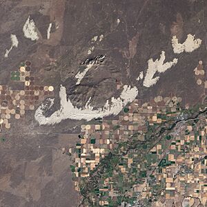
North and northwest of the city are the St. Anthony Sand Dunes. This huge area of white sand is about 10,600 acres. It's a special protected area. These dunes are home to one of the largest groups of elk in the United States during winter. Besides 2,500 elk, there are also 1,500 mule deer and 500 moose. In the spring, hundreds of people visit the dunes to collect antlers that the animals have shed. The sand dunes are also a popular place for off-road vehicles and bonfires. Some of the dunes are very tall, reaching up to 400 feet!
Famous People from St. Anthony
- Brandon Bair: A former professional football player for teams like the Kansas City Chiefs and Philadelphia Eagles.
- Earl W. Bascom: A pioneer in rodeo, known as the "Father of Modern Rodeo." He is in the Idaho Rodeo Hall of Fame.
- Jason Buck: A former professional football player who won Super Bowl XXVI.
- Dean Cain: An actor famous for playing Clark Kent / Superman.
- Erik Estrada: An actor and police officer.
- Brad Harris: A television and film actor.
- Sherman P. Lloyd: A politician who served as a Utah State Senator and a US representative from Utah.
- Charles C. Moore: A politician who was the governor of Idaho from 1923 to 1927.
See also
 In Spanish: St. Anthony (Idaho) para niños
 | Audre Lorde |
 | John Berry Meachum |
 | Ferdinand Lee Barnett |


