St. Francis, Maine facts for kids
Quick facts for kids
St. Francis
Saint-François
|
|
|---|---|

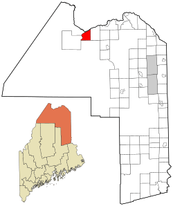
Location of St. Francis, Maine
|
|
| Country | United States |
| State | Maine |
| County | Aroostook |
| Villages | St. Francis Back Settlement Bradbury |
| Area | |
| • Total | 30.36 sq mi (78.63 km2) |
| • Land | 29.92 sq mi (77.49 km2) |
| • Water | 0.44 sq mi (1.14 km2) |
| Elevation | 1,240 ft (378 m) |
| Population
(2020)
|
|
| • Total | 438 |
| • Density | 15/sq mi (5.7/km2) |
| Time zone | UTC-5 (Eastern (EST)) |
| • Summer (DST) | UTC-4 (EDT) |
| Zip Code |
04774
|
| Area code(s) | 207 |
| FIPS code | 23-65025 |
| GNIS feature ID | 0582708 |
St. Francis (in French, Saint-François) is a small town. It is located in Aroostook County, Maine, in the United States. The town sits right on the border with Canada.
St. Francis is found where two rivers meet. These are the St. Francis River and the Saint John River. In 2020, about 438 people lived there. English speakers from southern Maine first settled the area. Over time, many French-speaking Acadians moved in.
Contents
Where is St. Francis Located?
St. Francis covers a total area of about 30.36 square miles (78.63 square kilometers). Most of this area is land. About 29.92 square miles (77.49 square kilometers) is land. The rest, about 0.44 square miles (1.14 square kilometers), is water. This information comes from the United States Census Bureau.
How Many People Live in St. Francis?
| Historical population | |||
|---|---|---|---|
| Census | Pop. | %± | |
| 1870 | 253 | — | |
| 1880 | 299 | 18.2% | |
| 1890 | 461 | 54.2% | |
| 1900 | 568 | 23.2% | |
| 1910 | 918 | 61.6% | |
| 1920 | 1,241 | 35.2% | |
| 1930 | 1,367 | 10.2% | |
| 1940 | 1,489 | 8.9% | |
| 1950 | 1,384 | −7.1% | |
| 1960 | 1,058 | −23.6% | |
| 1970 | 811 | −23.3% | |
| 1980 | 839 | 3.5% | |
| 1990 | 683 | −18.6% | |
| 2000 | 577 | −15.5% | |
| 2010 | 485 | −15.9% | |
| 2020 | 438 | −9.7% | |
| U.S. Decennial Census | |||
St. Francis Population in 2010
The census in 2010 counted 485 people living in St. Francis. There were 234 households and 143 families. The town had about 16.2 people per square mile. There were 316 housing units in total.
Most of the people in St. Francis were White (96.9%). Some were Native American (1.9%). A small number (1.2%) were from two or more races. Less than 1% of the population was Hispanic or Latino.
About 19.2% of households had children under 18. Nearly half (49.6%) were married couples. About 8.1% had a female head of household without a husband. Only 3.4% had a male head of household without a wife. Many households (38.9%) were not families.
About 33.8% of all households had only one person living there. Also, 11.5% had someone living alone who was 65 or older. The average household had 2.07 people. The average family had 2.61 people.
The average age in town was 51.3 years. About 15.1% of residents were under 18. Around 4.2% were between 18 and 24. A larger group (21.2%) was aged 25 to 44. The biggest group (36.8%) was aged 45 to 64. About 22.5% were 65 years or older. The town had slightly more males (50.1%) than females (49.9%).
Schools in St. Francis
St. Francis used to have its own school. It was called the St. Francis Elementary School. This school was part of the Maine School Administrative District 27.
However, the school closed in 2016. Now, students from St. Francis in Pre-K through 5th grade go to Fort Kent Elementary School. This school is in Fort Kent, Maine. It is also part of the same school district. The old St. Francis school building is now used as the St. Francis town office.
See also
 In Spanish: St. Francis (Maine) para niños
 | Claudette Colvin |
 | Myrlie Evers-Williams |
 | Alberta Odell Jones |

