St. Francis County, Arkansas facts for kids
Quick facts for kids
Saint Francis County
|
|
|---|---|

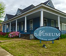
St. Francis County Museum in Forrest City, Arkansas.
|
|

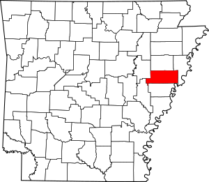
Location within the U.S. state of Arkansas
|
|
 Arkansas's location within the U.S. |
|
| Country | |
| State | |
| Founded | October 13, 1827 |
| Named for | St. Francis River |
| Seat | Forrest City |
| Largest city | Forrest City |
| Area | |
| • Total | 643 sq mi (1,670 km2) |
| • Land | 635 sq mi (1,640 km2) |
| • Water | 7.7 sq mi (20 km2) 1.2%% |
| Population
(2020)
|
|
| • Total | 23,090 |
| • Density | 35.91/sq mi (13.865/km2) |
| Time zone | UTC−6 (Central) |
| • Summer (DST) | UTC−5 (CDT) |
| Congressional district | 1st |
St. Francis County is a place in Arkansas, a state in the United States. In 2020, about 23,090 people lived there. The main town, or county seat, is Forrest City.
This county is part of the Forrest City, Arkansas area. It is also included in a larger region that connects to Memphis, Tennessee.
Contents
History of St. Francis County
St. Francis County was created on October 13, 1827. At first, the town of Madison was the county seat. Later, in 1874, Forrest City became the new county seat. Forrest City was founded in 1869.
In the late 1800s, many farmers in the county did not own their land. They were called tenant farmers. The number of tenant farmers grew from about 43% in 1880 to over 70% by 1900.
The county is in the eastern part of Arkansas, in an area called the Arkansas Delta. This area has lowlands near the Mississippi River. Long ago, it was known for large cotton farms. Many workers on these farms were enslaved African Americans. After slavery ended, many of these people became sharecroppers, meaning they farmed land owned by others and shared their crops.
Geography of St. Francis County
St. Francis County covers about 643 square miles. Most of this area, about 635 square miles, is land. The rest, about 7.7 square miles, is water.
Main Roads in St. Francis County
 Interstate 40
 U.S. Highway 70
 Highway 1
 Highway 38
 Highway 50
 Highway 75
Neighboring Counties
St. Francis County shares borders with these counties:
- Cross County (to the north)
- Crittenden County (to the east)
- Lee County (to the south)
- Monroe County (to the southwest)
- Woodruff County (to the northwest)
People of St. Francis County
In 2020, there were 23,090 people living in St. Francis County. There were 9,388 households and 5,867 families.
According to the 2020 census, the population was made up of different groups:
- About 39.87% were White.
- About 54.14% were Black or African American.
- About 0.28% were Native American.
- About 0.53% were Asian.
- About 2.21% were from other races or mixed races.
- About 2.97% were Hispanic or Latino (who can be of any race).
Towns and Communities
Cities in St. Francis County
- Forrest City (This is the county seat)
- Madison
Towns in St. Francis County
Townships in St. Francis County
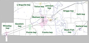
Townships in Arkansas are the divisions of a county. Each township includes unincorporated areas; some may have incorporated cities or towns within part of their boundaries. Arkansas townships have limited purposes in modern times. However, the United States Census does list Arkansas population based on townships (sometimes referred to as "county subdivisions" or "minor civil divisions"). Townships are also of value for historical purposes in terms of genealogical research. Each town or city is within one or more townships in an Arkansas county based on census maps and publications. The townships of St. Francis County are listed below; listed in parentheses are the cities, towns, and/or census-designated places that are fully or partially inside the township.
- Black Fish
- Franks (a small part of Forrest City is here)
- Garland (Hughes is here)
- Goodwin
- Griggs (Widener is here)
- Heth
- Johnson
- L'Anguille
- Madison (most of Forrest City and Madison are here)
- Prairie (Palestine is here)
- Telico (Caldwell, Colt, and a small part of Forrest City are here)
- Wheatley (most of Wheatley is here)
Schools in St. Francis County
Children in St. Francis County attend schools in these districts:
- Forrest City School District
- Palestine-Wheatley School District
- West Memphis School District
The Hughes School District used to be here but is no longer active.
Famous People from St. Francis County
- Al Green, a famous soul singer
- Charlie Rich, a country music singer
- Sonny Liston, a world heavyweight boxing champion
- Mark R. Martin, who served as the Secretary of State of Arkansas
See also
 In Spanish: Condado de Saint Francis para niños
 | William L. Dawson |
 | W. E. B. Du Bois |
 | Harry Belafonte |


