
St. Peter-Pagig facts for kids
Quick facts for kids
St. Peter-Pagig
|
||
|---|---|---|
 |
||
|
||

St. Peter-Pagig
Location in Switzerland

St. Peter-Pagig
Location in Canton of Graubünden
|
||
| Country | Switzerland | |
| Canton | Graubünden | |
| District | Plessur | |
| Area | ||
| • Total | 12.15 km2 (4.69 sq mi) | |
| Elevation | 688 m (2,257 ft) | |
| Population
(Dec 2010)
|
||
| • Total | 214 | |
| • Density | 17.61/km2 (45.62/sq mi) | |
| Demonym(s) | Pagig, St. Peter | |
| Postal code |
7028 St. Peter GR
|
|
| Surrounded by | Castiel, Furna, Lüen, Molinis, Peist, Trimmis | |

St. Peter-Pagig was a small town, or municipality, in the Grisons area of Switzerland. It was part of the Plessur district. A municipality is like a local government area.
St. Peter-Pagig was created on January 1, 2008. It was formed when two smaller towns, St. Peter and Pagig, decided to join together. This is called a merger.
Later, on January 1, 2013, St. Peter-Pagig merged again. This time, it joined with several other towns: Calfreisen, Castiel, Langwies, Lüen, Molinis, and Peist. All these towns became part of a new, larger municipality called Arosa.
Where is St. Peter-Pagig Located?
Before it merged, St. Peter-Pagig covered an area of about 12.1 square kilometers (which is about 4.7 square miles).
This former town was located in a beautiful area called the Schanfigg valley. It was on the northern side of the middle part of this valley.
You could find the Sankt Peter-Molinis railway station near the border with the town of Molinis. This train station is part of the Chur-Arosa train line.
-
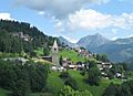
St Peter village
-
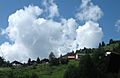
Pagig village

How Many People Lived There?
In 2010, St. Peter-Pagig had a population of 214 people.
When St. Peter was a separate town in 2008, it had 241 residents.
Here is a quick look at how the population changed over the years:
| Year | Population |
|---|---|
| 1808 | 272 |
| 1900 | 203 |
| 1950 | 240 |
| 2000 | 232 |
See also
 In Spanish: Sankt Peter-Pagig para niños
