St. Vincent, Minnesota facts for kids
Quick facts for kids
St. Vincent, Minnesota
|
|
|---|---|

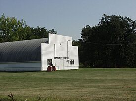
St Vincent Community Center
|
|

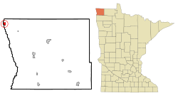
Location of St. Vincent, Minnesota
|
|
| Country | United States |
| State | Minnesota |
| County | Kittson |
| Incorporated | May 23, 1857 |
| Area | |
| • Total | 1.083 sq mi (2.803 km2) |
| • Land | 1.027 sq mi (2.659 km2) |
| • Water | 0.056 sq mi (0.144 km2) |
| Elevation | 794 ft (242 m) |
| Population
(2020)
|
|
| • Total | 57 |
| • Estimate
(2022)
|
52 |
| • Density | 55.50/sq mi (21.44/km2) |
| Time zone | UTC−6 (Central (CST)) |
| • Summer (DST) | UTC−5 (CDT) |
| ZIP Code |
56755
|
| Area code(s) | 218 |
| FIPS code | 27-58144 |
| GNIS feature ID | 0651079 |
| Sales tax | 6.875% |
St. Vincent is a small community called a hamlet in Kittson County, Minnesota, United States. It is located right across the Red River of the North from Pembina, North Dakota. In 2020, about 57 people lived there.
Contents
A Look at St. Vincent's Past
St. Vincent became an official community in 1857. This was just before Minnesota became a state. In 1878, a train line called the St. Paul & Pacific Railroad reached St. Vincent. This made it easier for people to move to the area. Many early settlers were Métis people. The Métis are a group of people with mixed Indigenous and European heritage. They had lived in this region since the late 1700s.
Where is St. Vincent Located?
St. Vincent is the westernmost community in the state of Minnesota. It sits right on the banks of the Red River of the North. This area is known as the Red River Valley.
The community grew from one of the oldest settlements in the region. It was once a fur-trading post set up by Peter Grant in 1793. Fur trading was a big business back then. The city of Pembina, North Dakota is just across the Red River to the west.
Main Roads in St. Vincent
Several important roads run through or near St. Vincent. These include Minnesota Highway 171 and U.S. Highway 75. Other local roads are 8th Street and Pacific Avenue. Nearby, you can also find North Dakota Highway 59 and Interstate 29.
Population Changes Over Time
| Historical population | |||
|---|---|---|---|
| Census | Pop. | %± | |
| 1900 | 256 | — | |
| 1910 | 328 | 28.1% | |
| 1920 | 343 | 4.6% | |
| 1930 | 304 | −11.4% | |
| 1940 | 327 | 7.6% | |
| 1950 | 272 | −16.8% | |
| 1960 | 217 | −20.2% | |
| 1970 | 177 | −18.4% | |
| 1980 | 141 | −20.3% | |
| 1990 | 116 | −17.7% | |
| 2000 | 117 | 0.9% | |
| 2010 | 64 | −45.3% | |
| 2020 | 57 | −10.9% | |
| 2022 (est.) | 52 | −18.7% | |
| U.S. Decennial Census 2020 Census |
|||
The number of people living in St. Vincent has changed a lot over the years. In 1900, there were 256 residents. The population grew for a bit, reaching 343 in 1920. Since then, it has slowly decreased. By 2020, the population was 57 people.
Who Lives in St. Vincent?
In 2010, there were 64 people living in St. Vincent. These people lived in 29 different homes. Most of the people (98.4%) were White. A small number (1.6%) were Native American. About 6.3% of the population identified as Hispanic or Latino.
The average age of people in St. Vincent was 49 years old. About 18.7% of residents were under 18. Many people were older, with 29.7% being 65 or older. The community had slightly more males (54.7%) than females (45.3%).
See also
 In Spanish: St. Vincent (Minnesota) para niños

