St Helier, London facts for kids
Quick facts for kids St Helier |
|
|---|---|
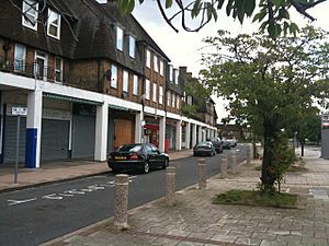
 Shops at Green Lane, St Helier |
|
| Population | 11,949 (2011 Census Sutton Ward) 10,414 (2011 Census. Merton Ward) |
| OS grid reference | TQ265664 |
| London borough | |
| Ceremonial county | Greater London |
| Region | |
| Country | England |
| Sovereign state | United Kingdom |
| Post town | MORDEN |
| Postcode district | SM4 |
| Post town | CARSHALTON |
| Postcode district | SM5 |
| Dialling code | 020 |
| Police | Metropolitan |
| Fire | London |
| Ambulance | London |
| EU Parliament | London |
| UK Parliament |
|
| London Assembly |
|
St Helier (/ˈhɛliər/) is a large neighborhood in London, England. It is mainly a residential area, meaning it has many homes. This area is special because it is split between two different parts of London: the Borough of Merton and the Borough of Sutton. The northern part of St Helier is in Merton, while the rest is in Sutton.
Contents
History of St Helier
The land where St Helier now stands has a long history of helping people. This goes back to the early 1600s!
Early Charity and Land Use
A rich man named Henry Smith, who passed away in 1627, gave a lot of money to help poor people in London and Surrey. In 1617, he donated £500 to buy land in Carshalton. The money earned from renting this land was used to support the poor in Wandsworth. Another kind person, Mrs. Elizabeth Blackwell, also left £100 for charity.
By 1814, these lands were about 116 acres and had a building and barns. They were known as the Wandsworth Poor Lands. Another local helper, Christopher Muschamp, who died in 1660, left money to help poor children get apprenticeships. This means they could learn a trade. Most of this area stayed like the countryside until the early 1900s.
Building the Estate
The St Helier estate was built between 1928 and 1936. It was created by the London County Council to provide new homes for people from crowded inner London areas. The idea was to make it a "garden city," with lots of green spaces and planned landscaping. A famous landscape architect named Edward Prentice Mawson helped design it.
The area grew quickly after the Morden Underground station opened in 1926. Also, a railway line from Wimbledon to Sutton opened in 1930, with a station right in St Helier. These train and tube services made it easy for people living in St Helier to travel to central London for work or other activities.
The estate was named after Lady St Helier. She was an important member of the London County Council from 1910 to 1927. St Helier was one of the largest "out-county" estates, meaning it was built outside the main city area. It followed the ideas of the Garden City plan by Ebenezer Howard. Before it became a housing estate, the area was mostly fields of lavender. This was part of the famous Mitcham lavender industry.
To remember the area's old connection to Westminster Abbey, the roads in St Helier are named after different monasteries and abbeys. They are even in alphabetical order, starting with Aberconway Road in the north-west and ending with Woburn Road in the south-east.
Important Buildings
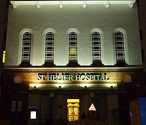
The large St Helier Hospital opened in 1938. A very famous person, John Major, who later became the Prime Minister of the UK from 1990 to 1997, was born there in 1943. The Bishop Andrewes Church, located on Wigmore Road, was designed by architect Geddes Hyslop in 1933.
St Helier Today
Today, the homes in St Helier are owned by both private individuals and the local council. Many people have bought their homes from the council since the 1970s.
The St Helier Hospital is still a very important part of the area. It provides many jobs and is a big building that stands out. Most of the original buildings in St Helier are still there and are used for their first purposes. Some new buildings have been added around the edges, and the estate now blends into the nearby areas of Sutton, Carshalton, and Morden.
Getting Around St Helier
St Helier is well-connected by public transport. Many London Bus routes serve the area, including the 80, 151, 154, 157, 164, 280, 470, N44, S1, and S2. The area also has its own train station, St Helier railway station, which makes it easy to travel by rail.
Nearby Places
- Rosehill
- Benhilton
- Morden
- Carshalton
- Mitcham
- Sutton
- Sutton Common
- Wallington
- Hackbridge
- Lower Morden
 | Aaron Henry |
 | T. R. M. Howard |
 | Jesse Jackson |


