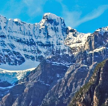
Stairway Peak facts for kids
Quick facts for kids Stairway Peak |
|
|---|---|
 |
|
| Highest point | |
| Elevation | 3,006 m (9,862 ft) |
| Prominence | 105 m (344 ft) |
| Geography | |
| Location | Alberta British Columbia |
| Topo map | NTS 82N/15 |
| Climbing | |
| First ascent | 1944 Mr. and Mrs. D.W. Measuroll, J. Monroe Thorington, Edward Feuz jr. |
Stairway Peak is a tall mountain in the Canadian Rockies. It stands 3,006 metres (9,862 ft) high. This peak is special because it sits right on the Continental Divide. This means it is on the border between two Canadian provinces: Alberta and British Columbia.
The mountain also marks the edge between two famous national parks. These are Banff National Park and Yoho National Park. You can even see Stairway Peak from the beautiful Icefields Parkway. A person named Arthur O. Wheeler gave the mountain its name in 1918.
How Stairway Peak Formed
Stairway Peak is made of a type of rock called sedimentary rock. This rock formed over millions of years, from the Precambrian time to the Jurassic period. Imagine tiny bits of sand, mud, and shells settling at the bottom of ancient, shallow seas. Over time, these layers pressed together and turned into solid rock.
Later, a huge event called the Laramide orogeny happened. This was a time when Earth's plates crashed into each other. This powerful force pushed the sedimentary rock layers upwards. It even pushed older rocks on top of younger ones, creating the mountains we see today, like Stairway Peak.
Weather and Climate
Stairway Peak is in a subarctic climate zone. This means the area has very cold winters with lots of snow. The summers are usually mild, not too hot.
Winter temperatures can drop below −20 °C (which is −4 °F). With the wind, it can feel even colder, sometimes below −30 °C (−22 °F). When snow and ice on the peak melt, the water flows in two directions. Some water drains east into the Mistaya River. Other water flows west into streams that join the Blaeberry River.
 | Jackie Robinson |
 | Jack Johnson |
 | Althea Gibson |
 | Arthur Ashe |
 | Muhammad Ali |


