
Stanton, California facts for kids
Quick facts for kids
Stanton, California
|
|||||
|---|---|---|---|---|---|

Stanton City Hall
|
|||||
|
|||||
| Motto(s):
"Community Pride and Forward Vision"
|
|||||

Location of Stanton within Orange County, California
|
|||||

Stanton, California
Location in the United States
|
|||||
| Country | |||||
| State | |||||
| County | |||||
| Founded | 1911 | ||||
| Incorporated | June 4, 1956 | ||||
| Government | |||||
| • Type | Council–manager | ||||
| Area | |||||
| • Total | 3.10 sq mi (8.03 km2) | ||||
| • Land | 3.10 sq mi (8.03 km2) | ||||
| • Water | 0.00 sq mi (0.00 km2) 0% | ||||
| Elevation | 66 ft (20 m) | ||||
| Population
(2020)
|
|||||
| • Total | 37,962 | ||||
| • Density | 12,213.55/sq mi (4,715.07/km2) | ||||
| Time zone | UTC-8 (PST) | ||||
| • Summer (DST) | UTC-7 (PDT) | ||||
| ZIP code |
90680
|
||||
| Area code | 657/714 | ||||
| FIPS code | 06-73962 | ||||
| GNIS feature ID | 1661501 | ||||


Stanton is a city in northern Orange County, California, United States. It is part of the larger Los Angeles metropolitan area. In 2020, about 37,962 people lived there.
Stanton became an official city in 1956. It uses a council-manager system, where elected council members make decisions and a city manager runs the daily operations. The city offers many services to its residents. Stanton is surrounded by other cities: Cypress to the west, Anaheim to the north and east, and Garden Grove to the east and south.
Contents
History of Stanton
Early Days and Native People
The Tongva people were the first inhabitants of the area where Stanton is now. Their villages, like Hutukunga and Puvunga, were close by.
The Arrival of Trains
On November 4, 1905, a train service called the Los Angeles Interurban Railway began. It ran between Watts and Santa Ana. This made it easier for people to travel, helping the area grow. This area is now Stanton and West Anaheim.
Later, in 1908, the Pacific Electric Railway took over the train service. By 1928, their large train system allowed people to travel easily across Los Angeles and Orange Counties. You can see a map of the train lines from 1928 here: See 1928 Map. Passenger train service stopped in 1950. Today, the land where the tracks used to be is still owned by the Orange County Transportation Authority (OCTA).
How Stanton Got Its Name
Stanton was named after Philip A. Stanton. He was a Republican assemblyman for Los Angeles from 1903 to 1909.
Becoming a City (and Then Not)
The first City of Stanton was officially formed in 1911. At that time, it was the largest city in Orange County by size. The main reason for becoming a city was to stop the City of Anaheim from building a "sewage farm" nearby. Philip Ackley Stanton helped with this, and the city was named after him.
However, in 1924, residents voted to stop being a city. They wanted to avoid the high costs of building roads.
Stanton Becomes a City Again
In the early 1950s, many people moved to the area after World War II. Nearby cities started taking over land. To protect their community, the citizens of Stanton voted to become a city again in May 1956. This is the City of Stanton we know today.
Geography and Climate
Where is Stanton Located?
Stanton is bordered by Anaheim to the north and Cypress to the west. A part of Stanton extends into Garden Grove, making Garden Grove a neighbor to the east, south, and west.
The city covers about 3.15 square miles (8.03 square kilometers) of land.
Stanton's Weather
Stanton has a mild climate. Here are some average temperatures and rainfall:
| Climate data for Stanton, California | |||||||||||||
|---|---|---|---|---|---|---|---|---|---|---|---|---|---|
| Month | Jan | Feb | Mar | Apr | May | Jun | Jul | Aug | Sep | Oct | Nov | Dec | Year |
| Record high °F (°C) | 91 (33) |
91 (33) |
97 (36) |
104 (40) |
99 (37) |
107 (42) |
107 (42) |
102 (39) |
108 (42) |
107 (42) |
96 (36) |
89 (32) |
108 (42) |
| Mean daily maximum °F (°C) | 67 (19) |
67 (19) |
67 (19) |
71 (22) |
73 (23) |
77 (25) |
81 (27) |
82 (28) |
81 (27) |
77 (25) |
72 (22) |
67 (19) |
74 (23) |
| Mean daily minimum °F (°C) | 47 (8) |
49 (9) |
51 (11) |
54 (12) |
58 (14) |
61 (16) |
65 (18) |
65 (18) |
64 (18) |
59 (15) |
51 (11) |
46 (8) |
56 (13) |
| Record low °F (°C) | 20 (−7) |
34 (1) |
37 (3) |
39 (4) |
48 (9) |
50 (10) |
58 (14) |
54 (12) |
52 (11) |
45 (7) |
37 (3) |
29 (−2) |
18 (−8) |
| Average precipitation inches (mm) | 2.8 (71) |
3.2 (81) |
2.1 (53) |
0.8 (20) |
0.2 (5.1) |
0.1 (2.5) |
0.0 (0.0) |
0.0 (0.0) |
0.2 (5.1) |
0.7 (18) |
1.1 (28) |
2.0 (51) |
13.2 (334.7) |
People of Stanton
Population Growth Over Time
Stanton's population has grown a lot since it was first incorporated.
| Historical population | |||
|---|---|---|---|
| Census | Pop. | %± | |
| 1920 | 695 | — | |
| 1960 | 11,163 | — | |
| 1970 | 18,186 | 62.9% | |
| 1980 | 23,723 | 30.4% | |
| 1990 | 30,491 | 28.5% | |
| 2000 | 37,403 | 22.7% | |
| 2010 | 38,186 | 2.1% | |
| 2020 | 37,962 | −0.6% | |
| 2022 (est.) | 38,952 | 2.0% | |
| U.S. Decennial Census | |||
Who Lives in Stanton?
In 2010, there were 38,186 people in Stanton.
- About 44.5% were White.
- About 23.1% were Asian.
- About 24.3% were from other races.
- About 50.8% of the people were Hispanic or Latino.
Most people (99.1%) lived in homes, not in group housing. There were 10,825 households. About 46.3% of these households had children under 18. The average household had about 3.5 people.
The population included:
- 27.7% under 18 years old.
- 29.6% aged 25 to 44.
- 10.0% aged 65 or older.
The median age was 33.0 years. This means half the people were younger than 33 and half were older.
In 2010, the average household income was $50,542. About 16.9% of the population lived below the poverty line.
Economy: Jobs in Stanton
Stanton has many businesses that provide jobs for its residents. Here are some of the top employers in the city as of 2021:
| # | Employer | # of Employees |
|---|---|---|
| 1 | Rowntree Gardens | 334 |
| 2 | The Home Depot | 165 |
| 3 | Super King Market | 128 |
| 4 | CR Transfer Inc. | 122 |
| 5 | Great Scott Tree Service | 122 |
| 6 | All Metals Process | 105 |
| 7 | Adventure City | 105 |
| 8 | Custom Pipe & Coupling | 104 |
| 9 | USS Cal Builders | 95 |
| 10 | Wal-Mart Neighborhood Market | 93 |
Fun Things to Do in Stanton
Stanton has several places where you can have fun and relax:
- Adventure City: A theme park with rides and attractions.
- Rodeo 39 Public Market: A place with food, shops, and entertainment.
- Stanton Central Park: A large park for outdoor activities.
Parks and Recreation in Stanton

Stanton has 10 parks for everyone to enjoy. These include:
- Beach & Orangewood Pocket Park
- Harry Dotson Park
- Hollenbeck Park
- Martha Weishaup Linear Park
- Norm Ross Sports Complex
- Premier Park
- Stanton Park
- Stanton Central Park (which has the Stanton Municipal Tennis Center)
- Veterans Memorial Park
- Zuniga Park
Inside Norm Ross Sports Complex, you'll find the Stanton Community Garden. Two new parks are also being built: a dog park and a small parkette. A great fact is that 74% of residents live within a 10-minute walk of a park!
The Stanton Community Services Department helps organize many activities and events for all ages. They also publish a guide called the Stanton Express.
The Stanton Family Resource Center (FRC) helps families reach their full potential by offering programs for both children and adults.
In the 1950s, a park called Lions-Stock Park was built with a sports facility and community center. This park was later bought by the school board.
Education in Stanton
Students in Stanton attend schools from four different public school districts. There is also one private school.
- The Garden Grove Unified School District runs a special education school called Carver (ECEC) in Stanton.
- The Savanna School District serves elementary school students.
- The Magnolia School District has schools that have been recognized for their academic achievements.
- The Anaheim Union High School District serves high school students.
- Saint Polycarp School is a private Catholic school for grades K-8.
Learning Resources for Kids
The Orange County Public Library has a branch in Stanton. It has over 60,000 books and offers story times, craft programs, and free Wi-Fi.
Next to the library is the Stanton Boys and Girls Club. They offer computer access, tutoring, and a homework help room for elementary school children.
Two other groups help kids learn and prepare for future careers:
- The Orange County Children's Theater puts on plays and musicals.
- The Future Scientists and Engineers of America helps middle and high school students learn about math, science, and engineering through hands-on projects.
City Services and Transportation
How to Get Around Stanton
Stanton is near several major freeways, making it easy to travel to other parts of California:
- North of the Garden Grove (22) Freeway.
- South of the Artesia (91) Freeway.
- East of the San Gabriel River (605) Freeway.
- West of the Santa Ana (5) Freeway.
Major streets running east-west include Cerritos Avenue, Katella Avenue, Orangewood Avenue, Chapman Avenue, Lampson Avenue, and Garden Grove Boulevard. Major streets running north-south include Knott Avenue, Western Avenue, Beach Boulevard, Dale Avenue, and Magnolia Avenue.
Emergency Services
For emergencies, Stanton has:
- Fire protection from the Orange County Fire Authority (OCFA).
- Ambulance services from Care Ambulance Service.
- Law enforcement services from the Orange County Sheriff's Department (OCSD).
In 1987, the city decided to use county agencies for police and fire services instead of having its own departments. In 2021, Stanton was named one of "California’s 50 Safest Cities" by Safewise.
Community Groups in Stanton
Many groups help make Stanton a great community:
- American Legion Post 783
- Greater Anaheim Chamber of Commerce
- Stanton Boys and Girls Club
- Stanton Kiwanis Club
- Stanton Lions Club
- Stanton City Presbyterian Church
Images for kids
-
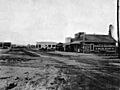
Downtown Stanton in 1913
-

Annual Stanton Easter Egg Hunt
See also
 In Spanish: Stanton (California) para niños
