
Stanton Mountain facts for kids
Quick facts for kids Stanton Mountain |
|
|---|---|
.jpg)
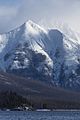
Stanton Mountain with Mount Vaught behind it
|
|
| Highest point | |
| Elevation | 7,750 ft (2,360 m) |
| Prominence | 630 ft (190 m) |
| Geography | |

Stanton Mountain
Location in Montana

Stanton Mountain
Location in the United States
|
|
| Location | Flathead County, Montana, U.S. |
| Parent range | Livingston Range |
| Topo map | USGS Camas Ridge East |

Stanton Mountain is a tall mountain in Glacier National Park, Montana. It stands 7,750 feet (2,360 m) high in the Livingston Range. This mountain rises more than 4,500 feet (1,400 m) above the northern shore of Lake McDonald.
The mountain was likely named after Mrs. Lottie Stanton. She lived near the west side of the park in the late 1800s. Mrs. Stanton and her husband ran a stable in the old town of Demersville. The name "Stanton Mountain" became official in 1929. The closest higher mountain is Mount Vaught, which is about 1.38 miles (2.22 km) to the northeast. Water from Stanton Mountain flows into streams that lead to the Flathead River.

What is the Climate Like on Stanton Mountain?
Stanton Mountain is in a subarctic climate zone. This means it has very long and cold winters. Summers are short and can be cool or mild. Temperatures can drop below −10 °F. With the wind, it can feel even colder, sometimes below −30 °F.
How Was Stanton Mountain Formed?
Stanton Mountain, like other mountains in Glacier National Park, is made of sedimentary rock. This type of rock forms from layers of sand, mud, and other materials that build up over millions of years. These rocks were laid down during ancient times, from the Precambrian to the Jurassic periods.
The rocks were first pushed up about 170 million years ago. This happened because of something called the Lewis Overthrust fault. Imagine a giant slab of rock, about 3 mi (4.8 km) thick, 50 miles (80 km) wide, and 160 miles (260 km) long. This huge piece of older rock slid over younger rock from the cretaceous period. This massive movement helped create the mountains we see today.
Images for kids
-
Mallards flying towards Stanton
-
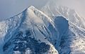
Stanton Mountain in winter
-
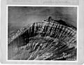
Aerial view of east side, around 1925


