Stanwood, Michigan facts for kids
Quick facts for kids
Stanwood, Michigan
|
|
|---|---|
|
Village
|
|

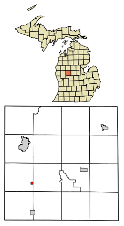
Location of Stanwood, Michigan
|
|
| Country | United States |
| State | Michigan |
| County | Mecosta |
| Township | Mecosta |
| Area | |
| • Total | 0.24 sq mi (0.63 km2) |
| • Land | 0.24 sq mi (0.63 km2) |
| • Water | 0.00 sq mi (0.00 km2) |
| Elevation | 974 ft (297 m) |
| Population
(2020)
|
|
| • Total | 194 |
| • Density | 801.65/sq mi (309.21/km2) |
| Time zone | UTC-5 (Eastern (EST)) |
| • Summer (DST) | UTC-4 (EDT) |
| ZIP code |
49346
|
| Area code(s) | 231 |
| FIPS code | 26-76240 |
| GNIS feature ID | 1621761 |
Stanwood is a small village located in Mecosta County, Michigan. As of the 2020 census, about 194 people lived there. The village is part of Mecosta Township.
Stanwood shares a special record with Mio. On July 13, 1936, it reached a temperature of 112 degrees Fahrenheit (44 degrees Celsius). This is the hottest temperature ever recorded in the state of Michigan!
Contents
Exploring Stanwood's Location
Stanwood is in the western part of Mecosta County. It is located in the southeastern area of Mecosta Township. To its east, you will find Austin Township.
The village is about 9 miles (14 km) south of Big Rapids. Big Rapids is the main city and county seat for Mecosta County. Stanwood is also about 6 miles (10 km) north of Morley.
Land and Water Features
The United States Census Bureau says that Stanwood covers a total area of 0.24 square miles (0.63 square kilometers). All of this area is land. There are no large bodies of water within the village limits.
Macks Creek is a small stream that flows through the southwest corner of Stanwood. It moves northwest and eventually joins the Muskegon River.
People of Stanwood: Population History
| Historical population | |||
|---|---|---|---|
| Census | Pop. | %± | |
| 1880 | 146 | — | |
| 1910 | 185 | — | |
| 1920 | 278 | 50.3% | |
| 1930 | 160 | −42.4% | |
| 1940 | 182 | 13.8% | |
| 1950 | 189 | 3.8% | |
| 1960 | 205 | 8.5% | |
| 1970 | 241 | 17.6% | |
| 1980 | 209 | −13.3% | |
| 1990 | 174 | −16.7% | |
| 2000 | 204 | 17.2% | |
| 2010 | 211 | 3.4% | |
| 2020 | 194 | −8.1% | |
| U.S. Decennial Census | |||
The Stanwood area was first settled in the 1850s by John Bell. He came from Ontario, Canada. John Bell was one of the first people to live in this area. He worked in logging, which means cutting down trees for wood. His logging community was called Bell's Siding. This area was near where Morley Stanwood Middle School and High School are today.
Stanwood's Population in 2010
According to the census from 2010, there were 211 people living in Stanwood. These people lived in 76 different homes. About 59 of these were family households.
The population density was about 879 people per square mile (340 people per square kilometer). Most of the people living in Stanwood were White (95.3%). A smaller number were African American (2.8%) or from two or more races (1.9%). About 2.8% of the population identified as Hispanic or Latino.
In 2010, about 40.8% of homes had children under 18 living there. Most homes (57.9%) were married couples living together. The average household had 2.78 people. The average family had 3.07 people.
The average age of people in the village was 37.4 years old. About 26.1% of residents were under 18. About 11.4% were 65 years old or older. There were slightly more males (51.2%) than females (48.8%) in the village.
Getting Around: Transportation
Indian Trails is a bus company that serves Stanwood. It offers daily bus service. You can travel between Grand Rapids and Petoskey, Michigan using this service.
What Stanwood Makes: Economy
Nestlé Waters North America has a factory in Stanwood. This factory produces bottled water brands. These brands include Ice Mountain and Nestlé Pure Life.
Famous People from Stanwood
- Ray Herbert – A professional baseball player.
See also
 In Spanish: Stanwood (Míchigan) para niños
 | Victor J. Glover |
 | Yvonne Cagle |
 | Jeanette Epps |
 | Bernard A. Harris Jr. |

