Stapleton, Georgia facts for kids
Quick facts for kids
Stapleton, Georgia
|
|
|---|---|

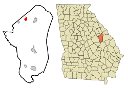
Location in Jefferson County and the state of Georgia
|
|
| Country | United States |
| State | Georgia |
| County | Jefferson |
| Area | |
| • Total | 1.74 sq mi (4.52 km2) |
| • Land | 1.74 sq mi (4.52 km2) |
| • Water | 0.00 sq mi (0.00 km2) |
| Elevation | 440 ft (134 m) |
| Population
(2020)
|
|
| • Total | 402 |
| • Density | 230.50/sq mi (89.01/km2) |
| Time zone | UTC-5 (Eastern (EST)) |
| • Summer (DST) | UTC-4 (EDT) |
| ZIP code |
30823
|
| Area code(s) | 706 |
| FIPS code | 13-73004 |
| GNIS feature ID | 0356555 |
Stapleton is a small city in Jefferson County, Georgia, in the United States. In 2020, about 402 people lived there.
A Look Back: Stapleton's History
Long ago, Stapleton had a different name. It was first called "Spread." In 1903, the Georgia General Assembly officially made it a town. This means it became a recognized place with its own local government. The city later changed its name to Stapleton. It was named after a person called Colonel James Stapleton.
Where is Stapleton?
Stapleton is located in the northwestern part of Jefferson County. You can find it at these coordinates: 33°12′57″N 82°28′5″W / 33.21583°N 82.46806°W. Georgia State Route 102 runs through the middle of the city. This road is also known as Main Street. If you go east on Route 102, you will reach Wrens in about 4.5 miles. If you go west, you will get to Avera in about 4 miles. Another road, State Route 296, crosses Route 102 in the city center. This road is made up of Harvey Street and George Street. Route 296 goes northeast for about 5 miles to SR-17 in Warren County. If you go south on Route 296, you will travel about 16 miles to Louisville. Louisville is the main city and county seat of Jefferson County. The United States Census Bureau says that Stapleton covers a total area of about 4.5 square kilometers (1.74 square miles). All of this area is land.
How Many People Live Here?
| Historical population | |||
|---|---|---|---|
| Census | Pop. | %± | |
| 1910 | 370 | — | |
| 1920 | 410 | 10.8% | |
| 1930 | 432 | 5.4% | |
| 1940 | 342 | −20.8% | |
| 1950 | 355 | 3.8% | |
| 1960 | 356 | 0.3% | |
| 1970 | 390 | 9.6% | |
| 1980 | 388 | −0.5% | |
| 1990 | 330 | −14.9% | |
| 2000 | 318 | −3.6% | |
| 2010 | 438 | 37.7% | |
| 2020 | 402 | −8.2% | |
| U.S. Decennial Census | |||
The number of people living in Stapleton has changed over the years. In the year 2000, a census (a count of all people) showed that 318 people lived in the city. There were 110 households, which are groups of people living together. By 2020, the population had grown to 402 people. This shows how the city's population has changed over time.
See also
 In Spanish: Stapleton (Georgia) para niños
 | Madam C. J. Walker |
 | Janet Emerson Bashen |
 | Annie Turnbo Malone |
 | Maggie L. Walker |

