Stob a' Choire Mheadhoin facts for kids
Quick facts for kids Stob a' Choire Mheadhoin |
|
|---|---|

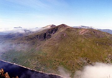
Stob a' Choire Mheadhoin seen across Loch Treig from Stob Coire Sgriodain, four km to the east. The crags of Coire Meadhon are in view. The summit of Stob Coire Easain can be seen to the left
|
|
| Highest point | |
| Elevation | 1,105 m (3,625 ft) |
| Prominence | 140 m |
| Parent peak | Stob Coire Easain |
| Listing | Munro |
| Naming | |
| English translation | Peak of the Middle Corrie |
| Language of name | Gaelic |
| Geography | |
| Location | Lochaber, Highland, Scotland |
| Parent range | Grampians |
| OS grid | NN316736 |
| Topo map | OS Landranger 41, OS Explorer 392 |
Stob a' Choire Mheadhoin is a mountain in the Scottish Highlands. It is located about 19 km east of Fort William. This mountain is part of the Lochaber area in the Highland region of Scotland.
Contents
What is Stob a' Choire Mheadhoin?
Stob a' Choire Mheadhoin stands 1105 metres (3625 feet) tall. This makes it one of the higher mountains known as Munros in Scotland. It is very close to another mountain called Stob Coire Easain. Stob Coire Easain is only 10 metres taller. It is about one kilometre to the southwest. A high col (a low point between two peaks) connects them. This col is about 965 metres high. People often climb both mountains together. They are sometimes called “The Easains” or “The Stob Coires”.
Some people think Stob a' Choire Mheadhoin is lucky to be a separate mountain. It could have been seen as just a smaller part of Stob Coire Easain. Older maps did not even name this hill. But its strong presence above Glen Spean likely led to its Munro status. It has been a Munro since 1891. This was when the first list of Munros was published. The best views of Stob a' Choire Mheadhoin are from the northeast. From there, it looks like its own distinct mountain.
How does the mountain look?
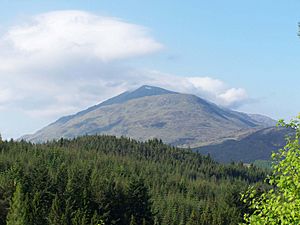
From the Laggan Dam, the mountain looks like a cone. It appears to stand alone. If you view it from Stob Coire Sgriodain, across Loch Treig, you can see its steep sides. These slopes drop sharply towards the loch. You can also see its impressive, rocky Coire Meadhon. This corrie gives the mountain its name. In Gaelic, "Stob a' Choire Mheadhoin" means "Peak of the Middle Corrie".
Exploring the Mountain's Features
Stob a' Choire Mheadhoin has a long ridge that stretches northeast. This ridge goes down for over five kilometres. It ends near the small village of Fersit. Fersit is located at the head of Loch Treig. This ridge is the most common way to climb the mountain. Most of it has a gentle slope. However, there are some steep parts. The climb up to Meall Cian Dearg is especially rocky. It might require some mild scrambling (climbing using hands and feet).
What are the slopes like?
The eastern side of the mountain drops steeply to Loch Treig. The slope rises 850 metres from the loch to the top. It has an average steepness of over 30 degrees. You can see these steep slopes well. They are visible when you travel on the West Highland Railway. This railway runs along the east side of the loch.
A ridge also goes southwest from the summit. This ridge connects to Stob Coire Easain. This is the mountain's twin Munro. The ridge follows the edge of the impressive Coire Easain Beag. This corrie sits between the two mountains. Coire Easain Beag has patches of red rock. These are mostly on its upper slopes. You can see them especially on the Stob a' Choire Mheadhoin side. A spot on the ridge at the top of the corrie is called Càrn Dearg. This means "Red Cairn" on the OS map.
What are the corries?
There are several corries on the eastern side of the mountain. The most striking one is Coire Meadhon. It drops directly from the summit. It has steep cliffs on its southern side. The northern slopes of the mountain go down into Coire Laire. Water from Coire Laire flows into the Allt Laire. This stream then goes north to join the River Spean. All the rain that falls on the mountain eventually flows into the River Spean.
How to Climb Stob a' Choire Mheadhoin
The most popular place to start climbing Stob a' Choire Mheadhoin is Fersit. This is a small village located at grid reference NN350784. From Fersit, you can reach the long northeast ridge. You then follow this ridge all the way to the summit.
Are there other ways to climb?
Another way to climb is from Corrour railway station. This involves using the West Highland Railway. This is a very long hike, about 30 km in total. It includes a big walk from the station. You walk around the head of Loch Treig. This takes you to the base of Stob Coire Easain. Most people climb Stob Coire Easain first. Then, they continue over Stob a' Choire Mheadhoin. The goal is to reach Tulloch railway station in time for the evening train.
 | DeHart Hubbard |
 | Wilma Rudolph |
 | Jesse Owens |
 | Jackie Joyner-Kersee |
 | Major Taylor |


