Stob Coire Easain facts for kids
Quick facts for kids Stob Coire Easain |
|
|---|---|

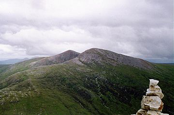
The Twins. Stob Coire Easain in front with Stob a' Choire Mheadhoin behind seen from Stob Bàn, 4 km to the W
|
|
| Highest point | |
| Elevation | 1,115 m (3,658 ft) |
| Prominence | 611 m (2,005 ft) |
| Parent peak | Ben Nevis |
| Listing | Munro, Marilyn |
| Naming | |
| English translation | Peak of the Corrie of the Little Waterfall |
| Language of name | Gaelic |
| Pronunciation | English approximation: STOP-kor-YƏ-ess--en |
| Geography | |
| Location | Highland, Scotland |
| Parent range | Grampians |
| OS grid | NN307730 |
| Topo map | OS Landranger 41, OS Explorer 392 |
Stob Coire Easain is a tall mountain in Scotland. It stands 1115 metres (3658 feet) high. You can find it about 18 kilometres east of Fort William.
This mountain is often called a "twin" because it stands next to another mountain, Stob a' Choire Mheadhoin. That mountain is 1105 metres high. Together, people call them "The Easains" or the "Stob Corries." They are only one kilometre apart. A high saddle of land, called a col, connects them. This col is about 965 metres high.
Between the two mountains is a cool, bowl-shaped valley called a corrie. It is named Coire Easain Beag and faces northwest. The name Stob Coire Easain comes from Gaelic. It means “Peak of the Corrie of the Little Waterfall”.
Contents
What Makes Stob Coire Easain Special?
Stob Coire Easain is a Munro. A Munro is a Scottish mountain over 914.4 metres (3,000 feet) high. This mountain stands out because it is surrounded by valleys on three sides. This makes it look very grand and isolated.
The Mountain's Shape and Surroundings
Stob Coire Easain is the highest point on a long ridge. This ridge stretches for nine kilometres. It runs along the entire western side of Loch Treig. The eastern side of this ridge drops very steeply down to the loch's water.
To the west of the mountain, there is a valley called Allt na Lairig. A smaller ridge goes north from the top of Stob Coire Easain. It starts steep and rocky as it goes down to the top of Coire Laire. South of the summit, the main ridge slopes gently. It goes over a place called Irlick Chaoile. This leads to a quiet area at the head of Loch Treig. All the water from the mountain flows into the River Spean. From there, it travels to the west coast of Scotland and into Loch Linnhe.
How to Explore The Easains
Because Stob Coire Easain and Stob a' Choire Mheadhoin are so close, people usually climb them together. It is a popular adventure for hikers.
Starting Your Mountain Climb
A good place to begin your climb is at a small village called Fersit. There is space to park cars there. From Fersit, climbers usually follow the northeast ridge of Stob a’ Choire Mheadhoin to its summit.
After reaching the top of Stob a’ Choire Mheadhoin, it's a steep climb down. Then, you climb back up across the stony col to reach the summit of Stob Coire Easain.
Other Ways to Reach the Summit
Another way to climb these mountains uses the West Highland Line. Hikers can start at Corrour railway station. From there, they walk around the head of Loch Treig. This path leads to the main ridge of The Easains. You can then walk across the ridge from south to north, finishing your journey back at Fersit.
Amazing Views from the Top
Stob Coire Easain is very tall and stands alone. This means it offers fantastic views. Looking west, you can see the Grey Corries and the Aonachs. Beyond them, you can even spot Ben Nevis, Scotland's highest mountain. It is a truly special sight!
 | Selma Burke |
 | Pauline Powell Burns |
 | Frederick J. Brown |
 | Robert Blackburn |

