Stob Bàn (Grey Corries) facts for kids
Quick facts for kids Stob Bàn |
|
|---|---|

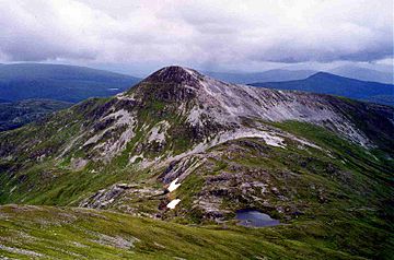
Stob Bàn from the slopes of Stob Choire Claurigh across the 800 metre col.
|
|
| Highest point | |
| Elevation | 977 m (3,205 ft) |
| Prominence | 174 m (571 ft) |
| Parent peak | Stob Choire Claurigh |
| Listing | Munro, Marilyn |
| Naming | |
| English translation | White Peak |
| Language of name | Gaelic |
| Pronunciation | English approximation: STOP-bahn |
| Geography | |
| Location | Highland, Scotland |
| Parent range | Grey Corries |
| OS grid | NN266724 |
| Topo map | OS Landranger 41, OS Explorer 392 |
Stob Bàn is a mountain located in the Lochaber area of Highland, Scotland. It stands about 16 kilometres (10 miles) east of Fort William. This impressive peak reaches a height of 977 metres (3,205 feet).
Stob Bàn is part of a group of mountains called the Grey Corries. This group includes three other Munros, which are Scottish mountains over 3,000 feet (914.4 metres) high. The name "Stob Bàn" comes from Gaelic and means "White Peak." This is because its slopes are covered in light-coloured schist rock, which makes it look different from the other Grey Corries mountains that have grey quartzite rock. Stob Bàn has a distinctive conical (cone-like) shape and stands out from its neighbours.
Contents
What Makes Stob Bàn Unique?
Stob Bàn is connected to the main Grey Corries ridge by a lower section of land called a col. This col is about 800 metres high and links Stob Bàn to Stob Choire Claurigh, the highest mountain in the Grey Corries group. A small, unnamed lochan (a Scottish term for a small loch or lake) can be found in this col.
How Is Stob Bàn Shaped?
Stob Bàn has three main ridges that give it its conical shape:
- The north-eastern ridge goes down into the valley of the Allt na Lairige river. This river flows south into Loch Treig.
- The south-western ridge slopes gently down to a col at 750 metres. From there, it rises to a smaller peak called Meall a’ Bhuirich, which is 841 metres high and about two kilometres from the main summit.
- The northern ridge is very steep. It connects Stob Bàn to the Munro of Stob Choire Claurigh. Walkers need to be careful here because the ground is covered in loose rock (scree).
What Is the "Giants Staircase"?
One interesting feature of Stob Bàn is something called the "Giants Staircase." This is a 200-metre long section of quartzite slabs. You might find it when you are walking down from the 800-metre col between Stob Bàn and Stob Choire Claurigh towards the Lairig Leacach. It can be tricky to walk on, especially when it's wet.
How Can You Climb Stob Bàn?
People often start their climb of Stob Bàn from Corrie Choille farm in Glen Spean. This is at grid reference NN251807.
What Is a Common Route to the Summit?
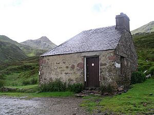
A popular way to climb Stob Bàn is to walk south from Corrie Choille farm. You follow an old Drovers' road that goes between Glen Spean and Loch Treig. This path takes you over the pass of the Lairig Leacach and down to the Lairig Leacach bothy. A bothy is a simple shelter, often unlocked, for walkers and climbers in remote areas. From the bothy, you can walk up the hillside to reach the east ridge, which leads directly to the summit of Stob Bàn.
Can You Climb Other Mountains with Stob Bàn?
Many hikers choose to climb Stob Bàn along with some or all of the other Grey Corries Munros. This longer walk also usually starts from Corrie Choille farm. From the top of Stob Bàn, you get amazing views of the Mamores mountains and the hills around Loch Treig.
 | Emma Amos |
 | Edward Mitchell Bannister |
 | Larry D. Alexander |
 | Ernie Barnes |


