
Stob Choire Claurigh facts for kids
Quick facts for kids Stob Choire Claurigh |
|
|---|---|
| Stob Choire Clamhraidh | |

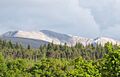
Stob Choire Claurigh above the Leanachan Forest. Seen from the north.
|
|
| Highest point | |
| Elevation | 1,177 m (3,862 ft) |
| Prominence | 446 m (1,463 ft) |
| Listing | Munro, Marilyn |
| Naming | |
| English translation | Peak of the Brawling Corrie |
| Language of name | Gaelic |
| Pronunciation | English approximation: stop-KHOR-yə-KLOW-ree |
| Geography | |
| Location | Highland, Scotland |
| Parent range | Grey Corries |
| OS grid | NN262738 |
| Topo map | OS Landranger 41, OS Explorer 392 |

Stob Choire Claurigh is a tall mountain in Scotland. It is located about 16 kilometers (10 miles) east of Fort William. This mountain is part of one of the best ridge walks in mainland Scotland. Its name comes from Scottish Gaelic and means "Peak of the Brawling Corrie".
About Stob Choire Claurigh
Stob Choire Claurigh is part of a mountain group called the Grey Corries. These mountains form a long ridge, about eight kilometers (five miles) long. The ridge stays high, never dropping below 800 meters (2,600 feet). There are twelve peaks along this ridge. Four of these peaks are called Munros. A Munro is a Scottish mountain that is over 914.4 meters (3,000 feet) high.
Stob Choire Claurigh is the highest mountain in the Grey Corries. It reaches a height of 1,177 meters (3,862 feet). The top part of the mountain is made of light grey quartzite rocks. These rocks make the mountain look very striking. You can see it well from the villages of Spean Bridge and Roybridge. The name "Peak of the Brawling Corrie" comes from the loud sounds of stags. Stags are male deer, and they make a lot of noise during their breeding season in the mountain's corries (bowl-shaped valleys).
Mountain Features
Stob Choire Claurigh is a large mountain with several smaller peaks. It also has four deep, high corries. These corries often hold snow late into the spring. Streams start high up on the mountain, around 1,000 meters (3,300 feet). All these streams eventually flow into the River Spean. The River Spean then reaches the west coast at Loch Linnhe.
The mountain has three main ridges that spread out from its top.
- The northern ridge goes down for two kilometers. It leads to a peak called Stob Coire Gaibhre, which is 958 meters (3,143 feet) high. This ridge continues into the Leanachan Forest.
- Near the summit on the northern ridge, there is a side path that goes east. This path leads to another peak called Stob Coire na Ceannain, which is 1,123 meters (3,684 feet) high. This path involves some easy climbing over rough, stony ground.
- The southern ridge connects to another Munro called Stob Ban. This connection is about 1.5 kilometers (one mile) away.
- The twisting southwest ridge goes for three kilometers. It passes over a peak called Stob a’ Choire Lèith, which is 1,105 meters (3,625 feet) high. This ridge then connects to the Munro of Stob Coire an Laoigh.
Climbing and Views
The most common way to climb Stob Choire Claurigh starts from Corriechoille farm. You can reach this farm by a small road from Spean Bridge. The path follows a track through a small part of the Leanachan Forest. After the forest, you leave the track and climb up steep slopes on the right side. This leads you to the north-east ridge.
You follow this ridge over Stob Coire Gaibhre. Then, you walk along the edge of Coire na Ceannain. This part gives you amazing views down to a round lochan (small lake) below. The summit is marked by a pile of quartzite boulders. From the top, you get a fantastic view. Looking southwest, you can see the twists and turns of the Grey Corries ridge. Behind it, you can see Aonach Beag and Ben Nevis, which is the highest mountain in the UK. Many hikers continue along the Grey Corries ridge. They eventually go down the north ridge of Stob Coire an Laoigh. This path leads back to the forest and then to Corriechoille.
Images for kids
-
Stob Choire Claurigh above the Leanachan Forest. Seen from the north.
