
Stockton Creek facts for kids
Quick facts for kids Stockton Creek |
|
|---|---|

Stockton Creek near its mouth
|
|

Location within California
|
|
| Physical characteristics | |
| Main source | Western Sierra Nevada Foothills 37°30′24″N 119°55′49″W / 37.5066°N 119.9302°W |
| River mouth | Mariposa Creek Mormon Bar 1,827 feet (557 m) 37°28′07″N 119°57′05″W / 37.4685°N 119.9513°W |
| Basin features | |
| River system | San Joaquin River |
Stockton Creek is a small stream, also called a tributary, that flows into Mariposa Creek in Mariposa County, California. It was named after Robert F. Stockton, who owned a mine and a special machine called a stamp mill there during the exciting time of the California Gold Rush. Today, a dam on Stockton Creek creates a reservoir that holds a lot of the water used by the community of Mariposa.
The creek starts near a place called Midpines Summit. It then flows until it joins Mariposa Creek near the Mariposa County Fairgrounds.
A Look Back: Stockton Creek's History
In 1850, during the California Gold Rush, Robert F. Stockton invested in a gold mine along this creek. He leased land from John C. Frémont, who owned a huge area called the Las Mariposas Land Grant.
Stockton teamed up with William Henry Aspinwall. In April 1850, they hired Edward Fitzgerald Beale to help bring a steam-powered stamp mill to their mine. A stamp mill was a big machine that crushed rocks to get the gold out. After setting up the mill, Beale went back east. Later, Stockton and Aspinwall asked him to return and check if the mine was making money. Beale found it wasn't very profitable. However, during this trip, Beale realized how important it would be to build a railroad across the Isthmus of Panama. This idea became a huge project for Aspinwall.
Aspinwall and Stockton eventually sold their parts of the Stockton Creek Mine. The mine kept working off and on until 1938, but it was most active between 1900 and 1915.
The area where Stockton Creek meets Mariposa Creek is known as Mormon Bar. This spot was, and still is, a busy place for businesses. During the Gold Rush, there were many different types of gold mines here. There were also placer claims, where people looked for gold in stream beds, and a stockyard for animals. In the mid-1900s, a company used old mining waste, called dredge tailings, to get sand and gravel. Today, the Mariposa County Fairgrounds are located at Mormon Bar.
Stockton Creek's Water System
Mariposa County has three main areas where water drains: the Merced River, the Chowchilla River/Fresno River, and a group of smaller streams near the east valley. All these streams are part of the much larger San Joaquin River system, which collects water from the western side of the Sierra Nevada mountains.
Near the end of the water system, Mariposa Creek has a dam called the Mariposa Creek Dam, which is about 88 feet (27 m) high. The Mariposa Public Utilities District (MPUD) also manages the Stockton Creek Dam on Stockton Creek. This dam is about 95 feet (29 m) tall.
Protecting Nature: Stockton Creek Preserve
In 2011, some areas around the Stockton Creek reservoir were set aside for public use. This happened thanks to a joint project between the Sierra Foothill Conservancy and the Mariposa Public Utilities District. This special area is called the Stockton Creek Preserve.
The main reason for the preserve is to protect the natural surroundings. This helps keep the water clean for Mariposa, since Stockton Creek Reservoir provides water to the town. The preserve also offers a beautiful place for people to enjoy nature. It covers 410 acres and has trails that cross private land, allowing visitors to explore.
-
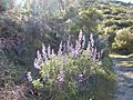
On Stockton Creek Preserve trail, Mariposa, CA
-
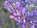
Wildflower close up, Stockton Creek Preserve trail, Mariposa, CA
-
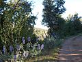
View from the Stockton Creek Preserve trail, Mariposa, CA


