Stratford, California facts for kids
Quick facts for kids
Stratford, California
|
|
|---|---|

Stratford, California
|
|

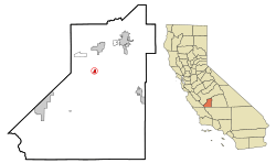
Location in Kings County and the U.S. state of California
|
|
| Country | |
| State | |
| County | |
| Founded | 1901 (as Stratton) |
| Area | |
| • Total | 0.683 sq mi (1.769 km2) |
| • Land | 0.683 sq mi (1.769 km2) |
| • Water | 0 sq mi (0 km2) 0% |
| Elevation | 203 ft (62 m) |
| Population
(2010)
|
|
| • Total | 1,277 |
| • Estimate
(2014)
|
900 |
| • Density | 1,869.7/sq mi (721.9/km2) |
| Time zone | UTC-8 (Pacific (PST)) |
| • Summer (DST) | UTC-7 (PDT) |
| ZIP code |
93266
|
| Area code(s) | 559 |
| FIPS code | 06-75252 |
| GNIS feature ID | 1661510 |
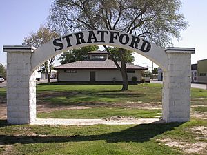
Stratford, once known as Stratton, is a small community in Kings County, California. It is located about 14 miles (23 km) southwest of Hanford. Stratford sits at an elevation of 203 feet (62 meters) above sea level. In 2010, the population of Stratford was 1,277 people.
Contents
Where is Stratford?
Stratford is located near where the historic Tulare Lake used to be. The Kings River flows into the dry lake bed about 10 miles (16 km) south of the town.
The United States Census Bureau says that Stratford covers an area of 0.7 square miles (1.8 square kilometers). All of this area is land. Stratford's exact location is 36°11′22″N 119°49′23″W.
Stratford's Story
The town was first started in 1901 and was called Stratton. It was named after William Stratton, who worked for the Empire Land and Water Company.
In 1906, a local women's club helped change the town's name to Stratford. The first post office in Stratford opened a few years later, in 1910.
From the 1930s to the 1970s, Stratford was home to a famous restaurant called Irigaray's. It was run by Mariana Irigaray and her daughter Alice. They were pioneers in creating a Basque-inspired style of cooking. This style later became known as California cuisine.
Many people in Stratford work in farming. The community has faced challenges like droughts, which affect agriculture.
Getting Around Stratford
Kings Area Regional Transit (KART) provides bus services in Kings County. They also offer vanpool services for people who travel to work and a Dial-A-Ride service.
![]() Highway 41 runs along the west side of Stratford. This highway connects Stratford to Kettleman City in the south and Lemoore in the north.
Highway 41 runs along the west side of Stratford. This highway connects Stratford to Kettleman City in the south and Lemoore in the north.
Learning in Stratford
Children in Stratford attend Stratford Elementary School. This school is part of the Central Union School District.
People of Stratford
Population in 2010
The 2010 Census showed that Stratford had 1,277 residents. Most of the people living in Stratford were of Hispanic or Latino background, making up about 83.7% of the population.
There were 312 households in Stratford. Many of these households, about 59%, had children under 18 living in them. The average household had about 4 people.
About 34% of the population was under 18 years old. The median age in Stratford was 27.6 years. This means half the people were younger than 27.6, and half were older.
Most homes, about 66%, were owned by the people living in them. The rest were rented.
Population in 2000
In the year 2000, Stratford had a population of 1,264 people. At that time, about 76% of the population was of Hispanic or Latino background.
About 41% of the people were under the age of 18. The median age was 24 years.
The average income for a household in Stratford was $29,205 per year. The average income for a family was $35,481 per year.
See also
 In Spanish: Stratford (California) para niños
 | Emma Amos |
 | Edward Mitchell Bannister |
 | Larry D. Alexander |
 | Ernie Barnes |

