
Strengelbach facts for kids
Quick facts for kids
Strengelbach
|
||
|---|---|---|
|
||

Strengelbach
Location in Switzerland

Strengelbach
Location in Canton of Aargau
|
||
| Country | Switzerland | |
| Canton | Aargau | |
| District | Zofingen | |
| Area | ||
| • Total | 6.03 km2 (2.33 sq mi) | |
| Elevation | 445 m (1,460 ft) | |
| Population
(Dec 2020 )
|
||
| • Total | 4,859 | |
| • Density | 805.8/km2 (2,087.0/sq mi) | |
| Postal code |
4802
|
|
| Surrounded by | Brittnau, Oftringen, Rothrist, Vordemwald, Zofingen | |

Strengelbach is a town, also called a municipality, in Switzerland. It is located in the Zofingen district, which is part of the canton of Aargau.
Contents
Geography of Strengelbach

Strengelbach covers an area of about 6.01 square kilometers (2.3 square miles). A large part of this land is covered by forests, making up about 44.6% of the area.
About 31.8% of the land is used for farming. This includes fields for crops and areas for animals to graze. The remaining 23% of the land is covered by buildings and roads. The town also has some flowing water, like rivers.
Strengelbach's Coat of Arms
Strengelbach has its own special symbol, called a coat of arms. It shows a wavy blue stripe on a gold background. This design is unique to the town.
People Living in Strengelbach
Strengelbach has a population of about 4,353 people (as of December 2006). In June 2009, about 24.8% of the people living in Strengelbach were from other countries.
Most people in Strengelbach speak German, which is about 85.4% of the population. Other languages spoken include Italian (4.8%) and Portuguese (2.2%).
The town has a good mix of ages. In 2008, about 10.2% of the population were children aged 0-9 years old. Teenagers aged 10-19 made up about 11.3% of the population.
Economy and Jobs
In 2007, Strengelbach had a low unemployment rate of 2.98%. This means most people who wanted to work had a job.
Many people in Strengelbach work in different areas:
- Farming: About 39 people work in farming, which is the primary economic sector.
- Manufacturing: Around 313 people work in factories or making things. This is the secondary sector.
- Services: About 792 people work in jobs like shops, offices, or healthcare. This is the tertiary sector.
In 2000, about 78.2% of the people living in Strengelbach traveled outside the town for work. At the same time, 675 people came into Strengelbach for their jobs. Many people use private cars (49.7%) to get to work, while some use public transportation (9.7%).
Religion in Strengelbach
According to the 2000 census, about 32.1% of the people in Strengelbach were Roman Catholic. About 49.8% belonged to the Swiss Reformed Church.
Education and Learning
Strengelbach has good educational opportunities. About 62% of adults (aged 25-64) have finished high school or gone on to higher education, like university.
In the 2008/2009 school year, there were 338 students in primary school and 130 students in secondary school in Strengelbach.
The town also has a public library called Gemeindebibliothek Strengelbach. In 2008, the library had over 7,645 books and other items. It loaned out nearly 24,000 items that year.
Images for kids
-
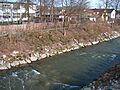
The Wigger River between Strengelbach and Zofingen.
-

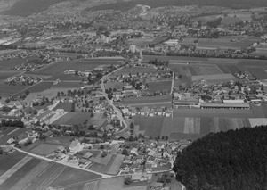
An aerial view of Strengelbach from 1964.
See also
 In Spanish: Strengelbach para niños
