Sunbright, Tennessee facts for kids
Quick facts for kids
Sunbright, Tennessee
|
|
|---|---|

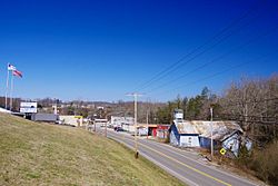
US 27 passing through Sunbright
|
|

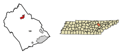
Location of Sunbright in Morgan County, Tennessee.
|
|
| Country | United States |
| State | Tennessee |
| County | Morgan |
| Settled | 1810s |
| Incorporated | 1990 |
| Area | |
| • Total | 3.53 sq mi (9.14 km2) |
| • Land | 3.53 sq mi (9.14 km2) |
| • Water | 0.00 sq mi (0.00 km2) |
| Elevation | 1,394 ft (425 m) |
| Population
(2020)
|
|
| • Total | 519 |
| • Density | 147.11/sq mi (56.80/km2) |
| Time zone | UTC-5 (Eastern (EST)) |
| • Summer (DST) | UTC-4 (EDT) |
| ZIP code |
37872
|
| Area code(s) | 423 |
| FIPS code | 47-72140 |
| GNIS feature ID | 2405547 |
Sunbright is a small city located in Morgan County, Tennessee, in the United States. In 2020, about 519 people lived there.
Contents
A Look Back: Sunbright's History
How Sunbright Got Its Name
People first started settling in the Sunbright area in the early 1800s. It was first called "Pine Top." Later, it was renamed "Stapleton" after the Staples family opened the town's first post office.
In 1879, a railroad was built through the area. The train station in Stapleton was named "Sunbright." Over time, the entire town became known by this name.
Oil Discovery and Growth
In 1916, oil was found in the hills just west of Sunbright. This discovery helped the city grow for several years. Sunbright became an important place for shipping oil. Within a year, one oil well was working. By 1927, there were 15 oil wells operating in the Sunbright area.
Sunbright's Location and Surroundings
Where Sunbright Is Located
Sunbright sits on top of the Cumberland Plateau. This is a large, flat area of land that is higher than the land around it. It is about 25 miles (40 km) west of a steep edge of the plateau called Walden Ridge.
The city is surrounded by low mountains and hills. These are part of the Cumberland Mountains.
Rivers and Roads Near Sunbright
White Oak Creek flows through Sunbright. This creek is part of the Big South Fork of the Cumberland River. The water from the Big South Fork meets the water from the Emory River near Pilot Mountain, which is just south of Sunbright.
Sunbright is located along U.S. Route 27. This main road connects Sunbright to other cities. To the south, it goes to Wartburg and Harriman. To the north, it leads to Huntsville, Tennessee and Lexington, Kentucky.
In the center of Sunbright, US 27 crosses State Route 329. This road connects Sunbright to Deer Lodge. US 27 also meets Interstate 40 about 25 miles (40 km) south of Sunbright.
Size of the City
The United States Census Bureau says that Sunbright covers a total area of about 3.8 square miles (9.8 square kilometers). All of this area is land.
People Living in Sunbright
Population Changes Over Time
Sunbright's population has changed over the years:
| Historical population | |||
|---|---|---|---|
| Census | Pop. | %± | |
| 1890 | 214 | — | |
| 2000 | 577 | — | |
| 2010 | 552 | −4.3% | |
| 2020 | 519 | −6.0% | |
| Sources: | |||
Who Lives in Sunbright (2020)
In 2020, there were 519 people living in Sunbright. These people lived in 203 households, and 124 of these were families.
Most people in Sunbright are White. Here's a quick look at the different groups:
| Group | Number | Percentage |
|---|---|---|
| White (not Hispanic) | 495 | 95.38% |
| Black or African American (not Hispanic) | 1 | 0.19% |
| Native American | 1 | 0.19% |
| Other/Mixed | 18 | 3.47% |
| Hispanic or Latino | 4 | 0.77% |
See also
 You can also read about Sunbright (Tennessee) in Spanish for kids: Sunbright (Tennessee) para niños

