
Susquehecka Creek facts for kids
Quick facts for kids Susquehecka Creek |
|
|---|---|

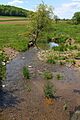
Susquehecka Creek looking upstream in its lower reaches
|
|
| Physical characteristics | |
| Main source | Pleasant Valley in Washington Township, Snyder County, Pennsylvania 614 ft (187 m) |
| River mouth | Middle Creek in Washington Township, Snyder County, Pennsylvania 436 ft (133 m) 40°46′28″N 76°54′09″W / 40.77434°N 76.90261°W |
| Length | 5.4 mi (8.7 km) |
| Basin features | |
| Progression | Middle Creek → Penns Creek → Susquehanna River → Chesapeake Bay |
| Basin size | 9.44 sq mi (24.4 km2) |
| Tributaries |
|
Susquehecka Creek is a cool stream in Snyder County, Pennsylvania, USA. It used to be called Freeburg Creek or Freeburg Run. This creek is about 5.4 miles (8.7 km) long. It flows through Washington Township and the town of Freeburg.
Susquehecka Creek is a tributary of Middle Creek. Its watershed, which is the area of land that drains into it, covers about 9.44 square miles (24.4 km2). The creek has one main branch called Dry Run. Some parts of Susquehecka Creek have too much dirt and mud from farming. This can make the water less healthy for fish.
The creek's watershed is a special place for fish. It is known as a Coldwater Fishery, meaning it's good for fish that like cold water. It's also a Migratory Fishery, which means fish travel through it to lay their eggs.
Contents
Where Does Susquehecka Creek Flow?

Susquehecka Creek starts in a wide, flat area called Pleasant Valley. This valley is located in Washington Township. The creek flows mostly east-northeast for a few miles. It even crosses Pennsylvania Route 35 twice along its path.
As the creek gets closer to Freeburg, another small stream called Dry Run joins it from the left side. Then, Susquehecka Creek turns northeast and enters the town of Freeburg. After a short distance, it turns east-southeast, then east-northeast again. It continues to follow Pennsylvania Route 35. Finally, after more than a mile, the creek reaches the end of Pleasant Valley. Here, it meets and joins Middle Creek.
Susquehecka Creek flows into Middle Creek about 3.22 miles (5.18 km) before Middle Creek reaches its own end.
What Are the Creek's Branches?
Susquehecka Creek has one main branch, or tributary, that has a name. This branch is called Dry Run. Dry Run flows into Susquehecka Creek in Freeburg. It joins the main creek about 2.64 miles (4.25 km) upstream from where Susquehecka Creek ends. The area of land that drains into Dry Run is about 1.83 square miles (4.7 km2).
Water Quality of the Creek
Some parts of Susquehecka Creek are considered "impaired." This means the water quality isn't as good as it should be. The main problem is too much siltation (fine dirt settling) and sedimentation (larger particles settling).
This extra dirt and mud mostly comes from agriculture, especially from animals grazing in fields near the creek. When animals walk on the land, they can loosen the soil. Rain can then wash this soil into the creek. This makes the water cloudy and can harm the plants and animals living there.
Land and Rocks Around the Creek
The land around Susquehecka Creek changes in height. Where the creek meets Middle Creek, its elevation is about 436 feet (133 m) above sea level. At its very beginning, the creek's source is higher, at about 614 feet (187 m) above sea level. The creek itself is a fairly small stream.
In the middle of the 1900s, people made big changes to the creek's path. They straightened parts of it, added walls (dikes), cleaned it, and made it wider and deeper. One book described the creek as a "limestone stream" but noted that the area around it wasn't very appealing.
The Creek's Watershed
The watershed of Susquehecka Creek covers an area of about 9.44 square miles (24.4 km2). The mouth of the creek is shown on a map called the United States Geological Survey Freeburg quadrangle. However, the creek's source is on a different map, the Dalmatia quadrangle.
Sometimes, flooding can happen along Susquehecka Creek and its branch, Dry Run, especially in the town of Freeburg. The main purpose of Susquehecka Creek, as officially recognized, is to support aquatic life. This means it's important for the plants and animals that live in and around the water.
History of Susquehecka Creek
Susquehecka Creek was officially added to the Geographic Names Information System on August 2, 1979. Its special ID number there is 1189115. For a while, the creek was also known as Freeburg Creek or Freeburg Run. A map from 1953 even used the name "Freeburg Creek."
However, in 1965, a researcher named William L. Cain found something interesting. He talked to many local people, including the mayor of Freeburg, a postmaster, and a farmer. None of them had ever heard of "Freeburg Creek." Everyone he spoke to knew it as "Susquehecka Creek." Even though only two people knew how to spell it, the name "Susquehecka Creek" had been used by locals for many years before 1965.
Over the years, several bridges have been built over Susquehecka Creek.
- In 1937, a concrete bridge was built to carry State Route 2003 over the creek. It's about 1 mile (1.6 km) south of Freeburg and is 42.0 feet (12.8 m) long.
- In 2008, a new bridge was built for Pennsylvania Route 35 to cross the creek. This bridge is about 3 miles (4.8 km) east of Fremont and is 64.0 feet (19.5 m) long. It replaced an older steel bridge that was built in 1952.
Animals in the Creek
The area that drains into Susquehecka Creek is special for fish. It's called a Coldwater Fishery, which means it's a good home for fish that need cold water. It's also a Migratory Fishery, meaning fish like trout travel through it. The creek has even been suggested as a future place where wild trout could live and thrive.
Images for kids
-
Susquehecka Creek looking upstream in its lower reaches
-

Susquehecka Creek looking downstream in its lower reaches
