Syrian Desert facts for kids
Quick facts for kids Syrian Desert |
|
|---|---|
| بادية الشام | |

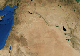
Syrian Desert by NASA
|
|

Syrian Desert on a topographic map
|
|
| Geography | |
| Country | Syria Iraq Jordan |
The Syrian Desert is a huge area of dry land in the Middle East. It's also called the Syrian steppe or the Badia. This desert covers about 500,000 square kilometers (193,000 square miles). That's a really big space!
You can find parts of the Syrian Desert in several countries. These include southeastern Syria, northeastern Jordan, northern Saudi Arabia, and western Iraq. It makes up a huge part of Jordan (85%) and Syria (55%). To the south, it connects with the Arabian Desert. The land is mostly open, with rocks or gravel, and sometimes dry riverbeds called wadis.
Contents
Where is the Syrian Desert?
This desert has natural borders around it. To the west, you'll find the Orontes Valley and an area of old volcanoes. To the east, it's bordered by the Euphrates River.
In the north, the desert slowly changes into greener areas with more grass. In the south, it joins the other deserts of the Arabian Peninsula.
Sometimes, people call the whole Syrian Desert the "Hamad Desert". But other times, Hamad only refers to a flat, stony area in the middle. Some parts of the Syrian Desert have their own names, like the Palmyrene desert near Palmyra. The part of the desert inside Iraq is sometimes called the Western Desert.
Geography of the Desert
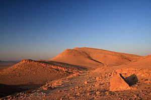
In the middle of the Syrian Desert is a high area called the Hamad Plateau. It's about 700 to 900 meters (2,300 to 3,000 feet) high. This plateau is mostly flat and stony. It's made of limestone rock covered with small, sharp stones called chert gravel. When it rains, the water often flows into salty, flat areas.
The highest points on the Hamad Plateau are over 1,000 meters (3,300 feet) high. One is Khawr um Wual in Saudi Arabia. Another is Jebel Aneiza, which is 960 meters (3,150 feet) high. This peak is special because it's where the borders of Jordan, Iraq, and Saudi Arabia meet.
The Hamad Desert, along with other deserts in the Arabian Peninsula, is known as one of the driest deserts in the world.
Amazing Desert Wildlife
Even though it's dry, the Syrian Badia (another name for the desert) has some special plants. These include Salsola vermiculata, Stipa barbata, Artemisia herba-alba, and Atriplex leucoclada.
However, this desert environment is in danger. Things like dry weather, too many animals eating the plants (over-grazing), and hunting are causing problems. Some animals that used to live here are gone now. Many types of plants have also disappeared. The grasses that grow instead are not as good for animals to eat.
Did you know the golden hamster comes from the Syrian Desert?
During certain seasons, you might see storks, herons, and cranes visiting the temporary lakes. Small rodents are common, and so are animals that hunt them, like snakes, scorpions, and camel spiders. In the past, there were many gazelles, wolves, foxes, and even ostriches and cheetahs. Sadly, most of the large animals are no longer found here, likely because of hunting by people.
History of the Syrian Desert
Ancient Times

For a very long time, Bedouin tribes have lived in the Syrian Desert. Many of these tribes still live there today, often in towns built near water sources called oases. Some Bedouin still follow their traditional desert lifestyle.
You can find ancient writings called Safaitic inscriptions all over the Syrian Desert. These are early Arabic texts written by Bedouin people between about 100 BC and 400 AD.
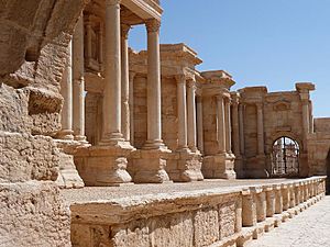
One of the most important ancient cities in the Syrian Desert was Palmyra. It was first mentioned thousands of years ago. During the time of the Roman Empire, Palmyra was a very important trading center. Its people were skilled merchants. They used the city's perfect location on the Silk Road, which connected the Far East to the Mediterranean Sea. They made a lot of money by taxing trading groups (caravans) that passed through. They also set up their own trading posts along the Silk Road and sold rare goods from far-off lands. This made Palmyra very rich. The people of Palmyra were a mix of Arameans, Amorites, and Arabs.
Another important ancient city was Dura-Europos, located on the Euphrates River. It started as a fortress built by the Seleucid Empire. Its location on the Euphrates was key, connecting Mesopotamia to the Mediterranean. This made it important for both trade and military travel. However, the city was attacked by the Sasanian emperor Shapur I in the 250s AD. Most people left, and the city was later abandoned.
Modern History
The Syrian Desert was first crossed by a car in 1919.
Economy and Farming
Because the Syrian Desert gets very little rain and has poor soil, it's mostly used for grazing animals today. Bedouin herders, many of whom still travel from place to place (are nomadic), bring their animals here. They graze about twelve million sheep and goats, along with some camels.
An organization called the International Fund for Agricultural Development helps reduce poverty in rural areas. In 1995, they worked with the Syrian government on a project. Their goal was to fix over a million hectares of damaged land in the Syrian Badia.
In some places, when animals were stopped from grazing too much, many native plants started growing back on their own. In other areas that were more damaged, they also planted new seeds and plants that animals could eat. By the time the project finished in 2010, a huge area had been reseeded. This project was a big success! Some herders even said their animals were much more productive, sometimes ten times more!
See also
 In Spanish: Desierto sirio para niños
 | George Robert Carruthers |
 | Patricia Bath |
 | Jan Ernst Matzeliger |
 | Alexander Miles |


