
Tacuarembó Department facts for kids
Quick facts for kids
Tacuarembó
|
||
|---|---|---|

Tacuarembó cathedral.
|
||
|
||

Location of Tacuarembó, in red, in Uruguay
|
||
| Country | ||
| Creation | 1837 | |
| Capital | Tacuarembó | |
| Area | ||
| • Total | 15,438 km2 (5,961 sq mi) | |
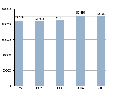
| Population
(2011)
|
||
| • Total | 90,053 | |
| • Density | 5.83320/km2 (15.1079/sq mi) | |
| Demonym(s) | Tacuaremboense | |
| Time zone | UTC-03 (UYT) | |
| ISO 3166 code | UY-TA | |
| Website | Official website: http://www.imtacuarembo.gub.uy | |

The Tacuarembó Department (which means Departamento de Tacuarembó in Spanish) is a special region in Uruguay. Think of it like a state or a large county. The main city and capital of this department is Tacuarembó.
This area has a special code, UY-TA, which helps identify it around the world.
Contents
What's in a Name?
The name "Tacuarembó" comes from the Tacuarembó River. This river is very important because it's the main river that flows into the Río Negro river.
A Look Back: Tacuarembó's History
Uruguay first divided its land into departments in 1816. Back then, the Paysandú Department was huge! It covered all the land north of the Río Negro river. This included areas that are now the Artigas, Rivera, Tacuarembó, Salto, Paysandú, and Río Negro departments.
On June 16, 1837, Uruguay changed its map again. The large northern territory was split into three parts. One of these new parts became the Tacuarembó Department. It even included the area that is now the Rivera Department until 1884, when Rivera became its own separate department.
Exploring Tacuarembó's Geography

The Tacuarembó Department is located in the north-central part of Uruguay. It is the largest department in the country. Its total area is about 15,438 square kilometers (or 5,961 square miles).
In 2011, about 90,053 people lived here. This means there are about 5.8 people living in every square kilometer. On the western side of the department, you'll find the Cuchilla de Haedo. These are chains of low, rounded hills.
Where is Tacuarembó?
Tacuarembó shares its borders with several other departments:
- To the north and northeast, it borders the Rivera Department.
- To the west, it borders the Salto, Paysandú, and Río Negro departments.
- To the south, it borders the Durazno and Cerro Largo departments. The Río Negro river separates Tacuarembó from these southern neighbors.
 |
Salto | Rivera | Rivera | |
| Paysandú | Cerro Largo | |||
| Río Negro | Durazno | Cerro Largo |
Important Rivers
The Río Negro river forms the southern border of the department. However, the most important river that flows entirely within Tacuarembó is the Tacuarembó River. This river is the main source of water for the Río Negro.
What's the Weather Like?
The climate in Tacuarembó, especially near Paso de los Toros, is known as a "Humid subtropical climate". This type of climate is often called Cfa.
On average, Paso de los Toros gets about 1,244.6 millimeters (49 inches) of rain each year. January is usually the wettest month, with about 132.1 millimeters (5.2 inches) of rain. December is typically the driest, with about 86.4 millimeters (3.4 inches) of rain.
The average temperature throughout the year in Paso de los Toros is 17.7°C (63.9°F). The warmest month is usually January, with an average temperature of 24.6°C (76.3°F). The coolest month is July, with an average temperature of 11.4°C (52.5°F).
Who Lives in Tacuarembó?
People who live in the Tacuarembó Department are called Tacuaremboenses in Spanish.
How the Population Has Changed
People Living in Rural Areas The 2011 census showed that about 9,660 people in Tacuarembó Department live in rural areas. These are places outside of the main towns and cities.
Main Towns and Cities Here are some of the biggest towns and cities in the Tacuarembó Department, along with how many people lived there in 2011:
| City / Town | Population (2011) |
|---|---|
| Tacuarembó | 54,755 |
| Paso de los Toros | 12,985 |
| San Gregorio de Polanco | 3,415 |
| Ansina | 2,712 |
| Las Toscas | 1,142 |
| Curtina | 1,037 |
Images for kids
-
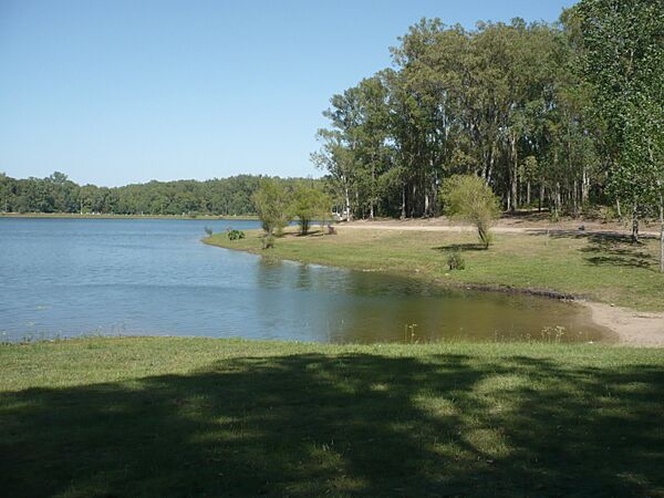
Iporá lake.
-
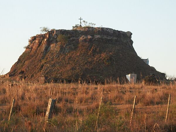
Cerro Cementerio.
-
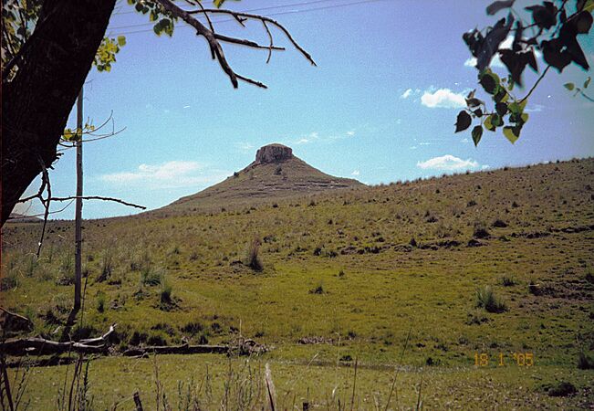
Cerro Batoví.


See Also
 In Spanish: Departamento de Tacuarembó para niños
