Templeton Gap facts for kids
Quick facts for kids Templeton Gap |
|
|---|---|

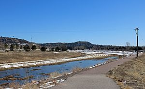
Templeton Gap Floodway, looking up towards the gap
|
|
| Location | Colorado Springs |
| Coordinates | 38°53′04″N 104°48′17″W / 38.88444°N 104.80472°W |
Templeton Gap is a natural opening between hills and bluffs in northeastern Colorado Springs. It is located in El Paso County, Colorado. This gap was an important pathway for Native Americans. They used it to reach Ute Pass. Later, it became a route for oxen trains heading to Colorado Springs. The gap is named after A.J. Templeton, who ran a ranch there.
When there are heavy rains, water can collect in a large area around the city. This water then flows through Templeton Gap. In the past, this caused very serious floods. To help prevent these floods, the Templeton Gap Floodway was built in 1949. Today, there is also a popular trail called the Templeton Gap Trail.
Contents
Where is Templeton Gap?
Templeton Gap is a narrow opening at the base of a curved line of rocky hills. These hills are about 800 feet (240 m) higher than the city of Colorado Springs. You can find it between the hills and bluffs just north of where Union Boulevard and Austin Bluffs Parkway meet.
History of Templeton Gap
Early Uses of the Gap
Native Americans used Templeton Gap as a main route to cross into the mountains near Pike's Peak. Their journey would take them through the gap, across Monument Creek, over the Mesa, and then along Fountain Creek to what is now Manitou Springs. From there, they connected to the original Ute Pass trail.
Naming Templeton Gap
The gap is named after A.J. (Jack) Templeton. He started a ranch in the Templeton Gap area in the 1860s. He was known for helping with births of babies, colts (young horses), and calves (young cows).
A Key Travel Route
Many oxen wagon trains used this gap to enter Colorado Springs. It was the most direct way to bring lumber from Pinery, which is now known as Black Forest.
Weather Records and Ranching
In the 1860s, Templeton Gap was one of the few places in Colorado that started collecting weather information. This project was supported by the Smithsonian Institution. It was led by Joseph Henry, who was the first federal meteorologist. In 1871, A. M. Merriam was the observer. He sheared 3,200 sheep the next year. By the 1880s, many large herds of sheep were raised in Templeton Gap.
Major Floods
In 1922, a severe hail and rain storm caused water to flow through Templeton Gap. It flooded Papeton with four feet of water. This storm destroyed barns, fences, roads, and even railroad tracks. It was considered the worst storm in 50 years for Templeton Gap. A more serious flood happened in July 1932.
Colorado Springs Country Club
The Colorado Springs Country Club was built on Templeton Gap Road. This land was once the McKnight Dairy Farm. The club officially became a member-owned country club in 1954.
Templeton Gap Floodway
The Templeton Gap Floodway is a 2 miles (3.2 km) long levee. It runs from east of Union Boulevard in the Pikeview neighborhood to Monument Creek. The US Army Corps of Engineers built it in 1949. Its main purpose is to move floodwater away from Shooks Run, which flows into Fountain Creek. Instead, the water is sent to Monument Creek.
The floodway was created to reduce the impact of major floods. Floods in the late 1800s and early 1900s had caused a lot of damage to the city. The City of Colorado Springs owns and maintains the floodway. It is designed to carry 13,500 cubic feet of flood water every second.
Templeton Gap Trail
The Templeton Gap Trail stretches for 4.42 miles (7.11 km) through Templeton Gap. It connects with the 3 miles (4.8 km) Sinton Trail. The trail also links to the Pikes Peak Greenway, Palmer Park, the Greencrest trail, Goose Gossage Sports Complex, Portal Park, and the Union Meadows Open Space. The Templeton Gap Trail starts at the Greencrest Trailhead on the north side of Palmer Park. It ends at the Goose Gossage Sports Complex.
 | Delilah Pierce |
 | Gordon Parks |
 | Augusta Savage |
 | Charles Ethan Porter |


