
Tennyson Down facts for kids
Quick facts for kids Tennyson Down |
|
|---|---|

Tennyson Down (chalk cliffs beyond bay)
|
|
| Highest point | |
| Elevation | 147 m (482 ft) |
| Listing | (none) |
| Geography | |
| Location | Isle of Wight, England |
| OS grid | SZ325853 |
| Topo map | OS Landranger 196 |
Tennyson Down is a beautiful hill on the western side of the Isle of Wight. It's near a village called Totland. This hill looks like a giant, grassy whale's back. It's made of chalk and rises about 147 meters (482 feet) above the sea.
The hill is named after a famous poet, Lord Tennyson. He lived nearby at Farringford House for almost 40 years. Lord Tennyson loved to walk on this hill almost every day. He even said the fresh air there was worth "sixpence a pint"!
Contents
Exploring Tennyson Down
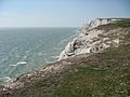
Tennyson Down is part of a long chalk ridge. This ridge forms the "backbone" of the Isle of Wight. To the west, this ridge stretches for about 5 kilometers (3 miles). It ends at the famous rock formations called The Needles.
To the east, the hill gently slopes down to Freshwater Bay. Here, the sea has cut right through the chalk ridge. On the south side, you'll find Highdown Cliffs. These are tall, almost straight chalk cliffs. They drop over 100 meters (328 feet) down to the sea below!
What You'll See on Top
The very top of Tennyson Down is mostly flat. It's covered in grass, making it a great place for walking. There are some small bushes and trees, especially on the northern side. This side is more sheltered from the strong winds.
The National Trust owns and takes care of Tennyson Down. They let cattle and rabbits graze here. This helps keep the grass short and healthy. The good news is that the Down is open for everyone to visit and enjoy.

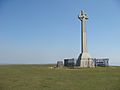
The Tennyson Monument
At the very top of the Down, you'll find a huge granite cross. It stands 147 meters (482 feet) high. This monument was built to remember Alfred Lord Tennyson.
On a clear day, the views from here are amazing! You can see Old Harry Rocks and the Isle of Purbeck to the west. To the north, you might spot Yarmouth and Lymington. Looking east, you can see much of the Solent (the sea strait). You might even see the Fawley Oil Refinery. A large part of the western Isle of Wight is also visible. You can even see St. Catherine's Point, which is about 20 kilometers (12 miles) away across Brighstone Bay.
It's a bit surprising, but you can't actually see The Needles from the monument. They are hidden behind the next hill to the west, which is called West High Down.
Walking and Nature
Famous Walking Trails
The Tennyson Trail is a well-known footpath on the Isle of Wight. It goes right along Tennyson Down. This trail is also part of the longer Isle of Wight Coast Path. So, it's a perfect spot for a hike!
A Special Place for Nature
Tennyson Down is one of the most important chalk downland areas in Britain. It's the western end of the Tennyson Heritage Coast. It's also part of the Headon Warren And West High Down SSSI. SSSI stands for "Site of Special Scientific Interest." This means it's a very important place for wildlife and plants. The Down is also part of the Isle of Wight’s Area of Outstanding Natural Beauty. This means its natural beauty is protected.
Images for kids
-
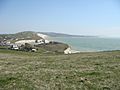
From Eastern side of Tennyson Down; looking towards Freshwater Bay
-
The Monument in the far distance
-
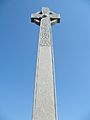
Close-up of Monument
-
Western face of Tennyson Monument
-
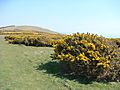
Shrubbery of Tennyson Down
-
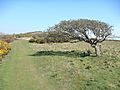
Trees face heavy wind thus grow in interesting shapes
-
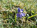
Tiny purple flower found on Tennyson Down
-
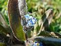
Tiny blue flower found on Tennyson Down


