
Territorial evolution of South Dakota facts for kids
This article explains how the land that is now the State of South Dakota changed hands over many years. It covers how different countries claimed the area and how it became part of the United States, eventually forming the state we know today.

Contents
Early Claims: European Powers
Before the United States existed, parts of North America were claimed by European countries. The land that would become South Dakota was no different.
British Claims: Rupert's Land
- The United Kingdom (Britain) claimed a large area called Rupert's Land from 1670 to 1870. This claim included parts of what is now South Dakota.
- However, the Anglo-American Convention of 1818 helped define the border between the U.S. and British North America. This agreement settled some of the land claims.
French Claims: Louisiane
- France also had a huge claim called Louisiane, starting in 1682. This vast territory stretched from the Great Lakes down to the Gulf of Mexico and included the South Dakota area.
- In 1762, France secretly gave this territory to Spain through the Treaty of Fontainebleau of 1762.
Spanish Claims: Luisiana
- After the secret treaty, Spain controlled the area, calling it Luisiana from 1764 to 1803.
- But in 1800, Spain secretly gave the territory back to France with the Third Treaty of San Ildefonso.
France's Brief Return and the Louisiana Purchase
- France briefly owned Louisiane again in 1803.
- However, later that year, France sold this massive territory to the United States. This famous event is known as the Vente de la Louisiane (Sale of Louisiana) or the Louisiana Purchase. This purchase greatly expanded the size of the United States.
Becoming Part of the United States
Once the United States bought the Louisiana Territory, the land that is now South Dakota began its journey to becoming a state.
Unorganized and Organized Territories
- Unorganized Territory (1803–1804): Right after the Louisiana Purchase, the area was simply "unorganized territory." This means it didn't have a formal government structure yet.
- District of Louisiana (1804–1805): For a short time, it was part of the District of Louisiana.
- Territory of Louisiana (1805–1812): It then became the Territory of Louisiana.
- Territory of Missouri (1812–1821): Later, it was included in the Territory of Missouri.
- Unorganized Territory Again (1821–1854): After Missouri became a state, the northwestern part of the Missouri Territory, including South Dakota, became unorganized again. The Treaty of Fort Laramie of 1851 was important during this time, as it defined boundaries for Native American tribes.
Different Territories Claiming Parts of South Dakota
Over the years, different U.S. territories claimed parts of the land east of the Missouri River:
- Territory of Michigan (1834–1836)
- Territory of Wisconsin (1836–1838)
- Territory of Iowa (1838–1846)
- Territory of Minnesota (1849–1858)
The land west of the Missouri River was part of the Territory of Nebraska from 1854 to 1861.
The Dakota Territory (1861-1889)
- In 1861, a large area was officially organized as the Territory of Dakota. This territory included not only present-day North and South Dakota but also parts of Montana and Wyoming.
- In 1882, some land between the 43rd parallel north and the Keya Paha River (or Niobrara River) was transferred to the State of Nebraska.
South Dakota Becomes a State
- Finally, on November 2, 1889, the southern part of the Dakota Territory officially became the State of South Dakota. At the same time, the northern part became the state of North Dakota.
- Since 1959, the map of the United States has looked much like it does today, with South Dakota as a proud state.
Images for kids
-
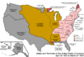
An enlargeable map of the United States after the Louisiana Purchase in 1803
-
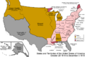
An enlargeable map of the United States after the Anglo-American Convention of 1818
-
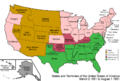
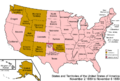
An enlargeable map of the United States after the Dakota Organic Act of 1861
-
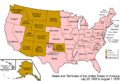
An enlargeable map of the United States after the Wyoming Organic Act of 1868
-
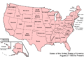
An enlargeable map of the United States after South Dakota statehood in 1889
-
An enlargeable map of the United States as it has been since 1959


