
Teusacá River facts for kids
Quick facts for kids Teusacá River |
|
|---|---|

Location of the Teusacá River in Colombia
|
|
| Country | Colombia |
| Department | Cundinamarca |
| Municipalities | |
| Localities | Santa Fe |
| Physical characteristics | |
| Main source | Eastern Hills Alto Los Tunjos 3,560 m (11,680 ft) 4°33′47.3″N 74°01′43.3″W / 4.563139°N 74.028694°W |
| River mouth | Bogotá River Cajicá 2,554 m (8,379 ft) 4°56′39.2″N 74°00′09.2″W / 4.944222°N 74.002556°W |
| Length | 69 km (43 mi) |
| Basin features | |
| River system | Bogotá River Magdalena Basin Caribbean Sea |
| Basin size | 358.17 km2 (138.29 sq mi) |
| Landmarks | PNN Chingaza |
| Waterbodies | San Rafael Reservoir |
The Teusacá River is an important river in Colombia. It flows through the Eastern Hills of Bogotá and across the Bogotá savanna. This river is a branch of the Bogotá River. It starts high up in the mountains and flows north, joining the Bogotá River in a town called Cajicá. The Teusacá River helps supply water to the capital city, Bogotá.
Contents
What's in a Name? The Teusacá River's History
The name Teusacá comes from Muysccubun. This was the language spoken by the Muisca. They lived in the Altiplano Cundiboyacense region a long time ago. This was before the Spanish arrived. Teusacá was also the name of a Muisca settlement. It was likely located near the river, between the towns of Guasca and Usaquén.
Teusacá River: Path and Importance
The Teusacá River is about 69 kilometres (43 mi) long. It begins very high up, at 3,560 metres (11,680 ft), in a place called Alto Los Tunjos. This area is part of the El Verjón Páramo in the Eastern Hills of Bogotá.
From its source, the river flows north. It passes through the town of La Calera. Here, the river feeds the San Rafael Reservoir. This reservoir is a very important source of drinking water for the city of Bogotá.
The Teusacá River then continues its journey north through Guasca. After that, it turns northwest, flowing through Sopó and Tocancipá. Finally, just north of Cajicá, the Teusacá River flows into the larger Bogotá River. This happens at an elevation of about 2,552 metres (8,373 ft). The river's basin, which is the area of land that drains into the river, covers about 358.17 square kilometres (138.29 sq mi).
Weather and Nature Around the River
The weather around the Teusacá River changes. The highest temperatures are usually between 12 to 15 °C (54 to 59 °F). The lowest temperatures are between 6 and 9 °C (43 and 48 °F). The river's water flow is highest in August and lowest in March.
The plants and animals around the river are very diverse. You can find different types of plants, from those in the high páramo areas to those in the Andean forests. Some common trees and plants include Illex kunthiana and Weinmannia tomentosa.
Many animals also live here. Over 300 different kinds of have been seen. There are also mammals, reptiles, and amphibians. Two important natural parks, the Chingaza National Natural Park and Páramo de Cruz Verde, are located east of the Teusacá River. These parks help protect the unique environment.
How the Land Was Formed: Geology
The area where the Teusacá River flows is part of the Eastern Ranges of the Colombian Andes. The river basin sits in a special dip in the land called a syncline. Imagine a giant U-shape in the rock layers. Over millions of years, different types of rocks formed here. These include very old rocks from the Late Cretaceous period and younger rocks from the Paleogene period.
There's also a large crack in the Earth's crust nearby called the Teusacá Fault. This fault has pushed older rock layers on top of newer ones. In the Teusacá River basin, there are also 25 active quarries. These quarries dig for carbon and materials used in construction.
Gallery
-
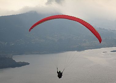
Paragliding over the San Rafael Reservoir
-
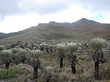
The Páramo de Cruz Verde is in the Teusacá River basin
-
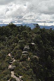
Sendero de la Cruz walking trail
-
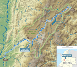
Teusacá River flowing into the Bogotá River just north of the 2550 m mark


See also
 In Spanish: Río Teusacá para niños
- List of rivers of Colombia, Muisca toponyms
- Eastern Hills, Bogotá
- Bogotá savanna
- Juan Amarillo, Fucha, Tunjuelo River
