Thompson Falls, Montana facts for kids
Quick facts for kids
Thompson Falls
|
|
|---|---|

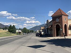
Downtown Thompson Falls
|
|
| Motto(s):
"Genuine In Nature"
|
|

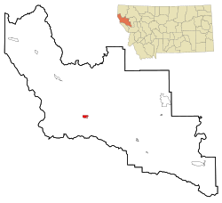
Location of Thompson Falls, Montana
|
|
| Country | United States |
| State | Montana |
| County | Sanders |
| Established | 1910 |
| Area | |
| • Total | 1.59 sq mi (4.13 km2) |
| • Land | 1.59 sq mi (4.13 km2) |
| • Water | 0.00 sq mi (0.00 km2) |
| Elevation | 2,556 ft (779 m) |
| Population
(2020)
|
|
| • Total | 1,336 |
| • Density | 838.14/sq mi (323.57/km2) |
| Time zone | UTC-7 (Mountain (MST)) |
| • Summer (DST) | UTC-6 (MDT) |
| ZIP code |
59873
|
| Area code(s) | 406 |
| FIPS code | 30-73825 |
| GNIS feature ID | 0792090 |
Thompson Falls is a city in Montana, United States. It is the main town, or county seat, of Sanders County. In 2020, about 1,336 people lived there.
Contents
Discovering Thompson Falls: A Look at Its Past
Thompson Falls got its name from David Thompson. He was a British explorer and fur trader. In 1809, he built a fur trading post here called Saleesh House. The town is located near natural waterfalls on the Clark Fork River.
In 1846, the Oregon Boundary Dispute was settled. This agreement made the area part of the United States. The arrival of the railroad in 1881 brought more people and activity. Two years later, a gold rush started nearby in Cœur d'Alene. Thompson Falls grew to help the miners traveling to the gold fields. In 1885, John Russell bought 40 acres of land and planned the town.
Thompson Falls was officially established in 1910. The Thompson Falls Dam was built on top of the original waterfalls. It has been working since 1915.
Where is Thompson Falls?
Thompson Falls is in the Clark Fork Valley. It sits at an elevation of about 2,419 feet (737 meters). The Clark Fork River flows along the southern side of the town. The town is also close to the Cabinet Mountains.
Thompson Falls State Park is a fun place to visit. It is about 2 miles (3.2 km) northwest of town. The park has a boat launch, places to camp, and nature trails for walking. The city itself covers about 1.73 square miles (4.48 square kilometers) of land.
Animals and Nature in Thompson Falls
A special type of amphibian lives near Thompson Falls. It is called the rough-skinned newt. This group of newts is separate from other newt groups in the Western U.S.
In 2010, a "fish ladder" was finished at the Thompson Falls Dam. This ladder has 48 pools, each one foot higher than the last. It helps native fish, like bull trout (Salvelinus confluentus), swim past the 913-foot (278-meter) dam. This was the first time they could do this in almost 100 years!
Weather in Thompson Falls
Thompson Falls has a climate that can be described in two ways. It is either an oceanic climate or a warm-summer humid continental climate. This means it has warm summers and cold winters.
| Climate data for Thompson Falls, Montana (1991–2020 normals, extremes 1956–present) | |||||||||||||
|---|---|---|---|---|---|---|---|---|---|---|---|---|---|
| Month | Jan | Feb | Mar | Apr | May | Jun | Jul | Aug | Sep | Oct | Nov | Dec | Year |
| Record high °F (°C) | 63 (17) |
71 (22) |
80 (27) |
93 (34) |
99 (37) |
103 (39) |
106 (41) |
107 (42) |
105 (41) |
88 (31) |
74 (23) |
61 (16) |
107 (42) |
| Mean daily maximum °F (°C) | 34.0 (1.1) |
39.8 (4.3) |
49.4 (9.7) |
58.2 (14.6) |
68.4 (20.2) |
74.5 (23.6) |
86.4 (30.2) |
86.2 (30.1) |
75.4 (24.1) |
58.0 (14.4) |
41.3 (5.2) |
32.9 (0.5) |
58.7 (14.8) |
| Daily mean °F (°C) | 29.1 (−1.6) |
32.3 (0.2) |
39.4 (4.1) |
46.3 (7.9) |
54.9 (12.7) |
61.1 (16.2) |
69.5 (20.8) |
68.8 (20.4) |
59.8 (15.4) |
46.9 (8.3) |
35.3 (1.8) |
28.7 (−1.8) |
47.7 (8.7) |
| Mean daily minimum °F (°C) | 24.1 (−4.4) |
24.9 (−3.9) |
29.4 (−1.4) |
34.4 (1.3) |
41.4 (5.2) |
47.8 (8.8) |
52.7 (11.5) |
51.5 (10.8) |
44.3 (6.8) |
35.9 (2.2) |
29.4 (−1.4) |
24.5 (−4.2) |
36.7 (2.6) |
| Record low °F (°C) | −22 (−30) |
−16 (−27) |
−6 (−21) |
17 (−8) |
24 (−4) |
32 (0) |
35 (2) |
32 (0) |
20 (−7) |
6 (−14) |
−7 (−22) |
−25 (−32) |
−25 (−32) |
| Average precipitation inches (mm) | 2.34 (59) |
1.94 (49) |
1.99 (51) |
1.65 (42) |
2.09 (53) |
2.19 (56) |
0.88 (22) |
0.89 (23) |
0.97 (25) |
2.16 (55) |
2.64 (67) |
2.31 (59) |
22.05 (560) |
| Average snowfall inches (cm) | 2.5 (6.4) |
0.6 (1.5) |
1.2 (3.0) |
0.3 (0.76) |
0.0 (0.0) |
0.0 (0.0) |
0.0 (0.0) |
0.0 (0.0) |
0.0 (0.0) |
0.7 (1.8) |
2.5 (6.4) |
7.5 (19) |
15.3 (39) |
| Average precipitation days (≥ 0.01 in) | 17.9 | 14.6 | 16.0 | 15.4 | 13.9 | 13.0 | 6.7 | 5.3 | 7.9 | 13.4 | 16.9 | 17.1 | 158.1 |
| Average snowy days (≥ 0.1 in) | 2.3 | 1.0 | 0.5 | 0.2 | 0.0 | 0.0 | 0.0 | 0.0 | 0.0 | 0.1 | 1.2 | 2.3 | 7.6 |
| Source: NOAA | |||||||||||||
Who Lives in Thompson Falls?
| Historical population | |||
|---|---|---|---|
| Census | Pop. | %± | |
| 1910 | 325 | — | |
| 1920 | 508 | 56.3% | |
| 1930 | 468 | −7.9% | |
| 1940 | 736 | 57.3% | |
| 1950 | 851 | 15.6% | |
| 1960 | 1,274 | 49.7% | |
| 1970 | 1,356 | 6.4% | |
| 1980 | 1,478 | 9.0% | |
| 1990 | 1,319 | −10.8% | |
| 2000 | 1,321 | 0.2% | |
| 2010 | 1,313 | −0.6% | |
| 2020 | 1,336 | 1.8% | |
| U.S. Decennial Census | |||
Population in 2010
In 2010, there were 1,313 people living in Thompson Falls. These people lived in 618 households. About 362 of these were families. The city had about 759 people per square mile (293 per square kilometer).
Most people in Thompson Falls were White (94.9%). There were also small numbers of Native American (1.6%), Asian (0.5%), and African American (0.2%) residents. Some people were from other backgrounds or more than one race. About 1.6% of the population was Hispanic or Latino.
About 24.9% of households had children under 18. Many households (46.1%) were married couples. About 19.4% of households had someone living alone who was 65 or older. The average age in the city was 46.2 years old.
Learning and Schools
Thompson Falls has its own school district, called Thompson Falls Public Schools. This district includes an elementary school, a middle school, and a high school.
Students attend Thompson Falls High School. It is a Class B school, which means it is a certain size. The school's sports teams are called the Blue Hawks. Students can choose to play eight different sports.
The Thompson Falls Public Library is also located in the town. It's a great place to find books and learn.
News and Radio
Thompson Falls has local newspapers that keep everyone informed. The Sanders County Ledger is a weekly newspaper. The Clark Fork Valley Press also serves the area. It comes out every week and has an online version too.
There is also a local radio station, KTFZ. It is an FM station licensed in Thompson Falls. It broadcasts programs from Montana Public Radio.
Getting Around Thompson Falls
Montana Highway 200 runs through Thompson Falls from east to west. Another road, Secondary Highway 471, meets Highway 200 on the western side of town.
The Thompson Falls Airport is located about 3 miles (4.8 km) southeast of the town. It is owned by the county and is open for public use.
Well-Known People from Thompson Falls
- Jennifer Fielder – She used to be a member of the Montana Senate.
- Greg Hinkle – He also used to be a member of the Montana Senate.
- Pat Ingraham – He was a member of the Montana House of Representatives.
- Marc Racicot – He was the 21st governor of Montana. He also used to lead the Republican Party.
See also
 In Spanish: Thompson Falls (Montana) para niños
 | Selma Burke |
 | Pauline Powell Burns |
 | Frederick J. Brown |
 | Robert Blackburn |

