
Thurmond, West Virginia facts for kids
Quick facts for kids
Thurmond, West Virginia
|
|||||||||||||||||||||||||||
|---|---|---|---|---|---|---|---|---|---|---|---|---|---|---|---|---|---|---|---|---|---|---|---|---|---|---|---|

Thurmond Depot, now a New River Gorge National Park and Preserve visitor center, and a single track bridge which crosses the New River.
|
|||||||||||||||||||||||||||

Location of Thurmond in Fayette County, West Virginia.
|
|||||||||||||||||||||||||||
| Country | United States | ||||||||||||||||||||||||||
| State | West Virginia | ||||||||||||||||||||||||||
| County | Fayette | ||||||||||||||||||||||||||
| Area | |||||||||||||||||||||||||||
| • Total | 0.09 sq mi (0.24 km2) | ||||||||||||||||||||||||||
| • Land | 0.09 sq mi (0.24 km2) | ||||||||||||||||||||||||||
| • Water | 0.00 sq mi (0.00 km2) | ||||||||||||||||||||||||||
| Elevation | 1,070 ft (326 m) | ||||||||||||||||||||||||||
| Population
(2020)
|
|||||||||||||||||||||||||||
| • Total | 5 | ||||||||||||||||||||||||||
| • Density | 42.55/sq mi (16.38/km2) | ||||||||||||||||||||||||||
| Time zone | UTC-5 (Eastern (EST)) | ||||||||||||||||||||||||||
| • Summer (DST) | UTC-4 (EDT) | ||||||||||||||||||||||||||
| ZIP code |
25936
|
||||||||||||||||||||||||||
| Area code(s) | 304/681 | ||||||||||||||||||||||||||
| FIPS code | 54-80284 | ||||||||||||||||||||||||||
| GNIS feature ID | 1555811 | ||||||||||||||||||||||||||
|
|||||||||||||||||||||||||||

Thurmond is a small town in Fayette County, West Virginia, United States. It sits right on the New River. In 2020, only five people lived there, making it the least populated town in West Virginia.
Long ago, when coal mining was a huge industry in the New River Gorge, Thurmond was a busy and important town. It had many businesses and facilities for the Chesapeake and Ohio Railway, which was a major train company.
Today, most of Thurmond is owned by the National Park Service. The old train station in town was fixed up in 1995 and is now a visitor center for the National Park. The whole town is a special historic area listed on the National Register of Historic Places.
Contents
History of Thurmond
Thurmond became an official town in 1900. It was named after Captain W. D. Thurmond, who first settled there in 1844. He got the land in 1873 as payment for a surveying job. He was a soldier in the Confederate Army and lived to be 90 years old, passing away in 1910.
The town stayed small until 1892. That's when Thomas G. McKell worked with the Chesapeake and Ohio Railway to build a train crossing at Dunloup Creek. This helped the town grow.
Captain W. D. Thurmond had a rule that no places selling certain adult beverages were allowed on his land, which was the original part of the town. However, the Dun Glen Hotel was just outside his land, and it had different rules.
Hotels and Banks in Thurmond
Thurmond once had two hotels. One was called the Lafayette, which was close to the train tracks. The other, the Dun Glen, opened in 1901 and became a very famous resort across the country. Sadly, the Dun Glen Hotel burned down in 1930.
The Thurmond National Bank, owned by the Thurmond family, closed in 1931. The New River Bank, owned by the McKell family, moved to Oak Hill in 1935.
Decline of the Town
Thurmond started to decline in the 1950s. This happened when trains changed from using steam engines to diesel engines. Diesel trains didn't need to stop as often for coal and water, so they could travel much further without stopping in Thurmond.
Another reason for the town's decline was in the late 1980s. At that time, the National Park Service began buying homes and properties from people who wanted to sell. The idea was to turn the town into a living history museum.
Thurmond's Historic District
The Thurmond Historic District includes the entire town and a small part of the riverbank on the other side. Until 1921, the only way to get to Thurmond was by train. The town is built on a narrow strip of flat land right next to the Chesapeake and Ohio Railway tracks. There isn't a road between the tracks and the town buildings.
Instead, a special single-lane road crosses the New River on a train bridge. It then crosses the main train line and goes up a hill behind the town. This road runs parallel to the town but about 150 feet higher up, before coming back down near the tracks. Even without a main road, the town's business area did very well because of its important spot on the train line.
The houses in Thurmond were built in a few standard styles. These styles often showed what job a person had in the railroad system. The business area, even without a street for a long time, had two hotels, two banks, and many other shops. The train station was built in 1888. There was also a train yard and shops to help with the many branch lines that carried coal out of the mountains.
The town once had hundreds of people living there, but now only a few remain. The old train station is now a visitor center for the New River Gorge National Park and Preserve.
Thurmond's Location
Thurmond's flat land is mostly used by the CSX train company, which used to be the Chesapeake and Ohio Railway. Besides a row of businesses that face the train tracks directly, the rest of the town climbs up the hill behind the flat area. Thurmond was a very important place for the C&O railway. It was where smaller trains from nearby coal mines would come together to form longer trains. These longer trains would then carry the coal to markets far away.
The town covers a total area of about 0.24 square kilometers (0.09 square miles), and all of it is land.
Thurmond's Population

| Historical population | |||
|---|---|---|---|
| Census | Pop. | %± | |
| 1910 | 315 | — | |
| 1920 | 285 | −9.5% | |
| 1930 | 462 | 62.1% | |
| 1940 | 339 | −26.6% | |
| 1950 | 219 | −35.4% | |
| 1960 | 189 | −13.7% | |
| 1970 | 86 | −54.5% | |
| 1980 | 67 | −22.1% | |
| 1990 | 39 | −41.8% | |
| 2000 | 7 | −82.1% | |
| 2010 | 5 | −28.6% | |
| 2020 | 5 | 0.0% | |
| U.S. Decennial Census | |||
In 2010, there were five people living in Thurmond, making up four households. None of these households were families. Three households had only one person living there, and two of those people were 65 years old or older. The average household size was 1.25 people.
The average age of people in Thurmond in 2010 was 57.5 years old. No residents were under 24. About 40% were between 25 and 44, 20% were between 45 and 64, and 40% were 65 or older. The population was 20% male and 80% female.
Train Travel to Thurmond
Amtrak, which is the national passenger train service, has a stop in Thurmond. This stop is part of the Cardinal train route. It is one of the least used train stations in the entire Amtrak network.
In 2022, 399 passengers used the Amtrak station in Thurmond, West Virginia. This was more than the 285 passengers in 2018. In 2023, the number grew to 466 passengers.
As of 2024, because not many people use the station, there are no staff members working there. There is also no waiting room or a place to buy tickets in person.
Thurmond in Movies and Stories
The town of Thurmond was used as a filming location for the 1987 movie Matewan. This is because Thurmond still looks a lot like a coal mining town from the 1920s in the Appalachian region. The real events the movie was based on happened in Matewan, West Virginia, which is about 100 miles away.
The McKell family, who owned land next to Captain W. D. Thurmond's property, had a famous hotel called the Dun Glen. This hotel was known for hosting a very long card game. Ripley's Believe It or Not even claimed it was the world's longest-lasting poker game, going on for 14 years!
Images for kids
-
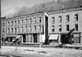
Commercial district along "Main Street" tracks
See also
 In Spanish: Thurmond (Virginia Occidental) para niños
