Tiger Mountain (Washington) facts for kids
Quick facts for kids Tiger Mountain |
|
|---|---|

|
|
| Highest point | |
| Elevation | 3,004 ft (916 m) NAVD 88 |
| Prominence | 1,644 ft (501 m) |
| Geography | |
| Location | Issaquah, Washington, US |
| Parent range | Issaquah Alps |
| Topo map | USGS Hobart |
Tiger Mountain is a tall mountain located in the state of Washington, in the United States. It is a popular spot for outdoor adventures. This mountain is part of a group of hills known as the Issaquah Alps.
Contents
About Tiger Mountain
Tiger Mountain has six main peaks. It forms a large triangle of land, covering about 13,500 acres (54.6 square kilometers). This area is bordered by major roads: Interstate 90 (I-90) to the north, Issaquah-Hobart Road to the southwest, and State Route 18 (SR 18) to the southeast.
Other mountains nearby include Squak Mountain and Cougar Mountain to the west. To the southeast, you'll find McDonald and Taylor Mountains, and Rattlesnake Ridge.
Tiger Mountain State Forest
The Tiger Mountain State Forest was created in 1981. It's a special place where nature is protected. In 1989, a large part of the forest, called the West Tiger Mountain Natural Resources Conservation Area, was set aside for conservation. This area is about 13,745 acres. You can get to it from a big trailhead at Exit 20 on I-90.
Popular Trails and Views
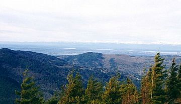
One of the most popular trails leads to the top of West Tiger #3. From here, you can see amazing views of Seattle and areas to the south and east. This hike is about 6.2 miles (10 kilometers) round-trip. It climbs about 2,000 feet (610 meters) in elevation. The nearby peaks of West Tiger #2 and West Tiger #1 offer similar great views, often with fewer trees blocking the way.
State Route 18 runs between Tiger Mountain and Taylor Mountain. This part of the highway is often called "Tiger Mountain Summit" in local traffic reports. There's another main trailhead at this summit. From here, you can reach South Tiger Mountain, which has some views. Middle Tiger Mountain offers a small view of the Cedar Hills Landfill. East Tiger Mountain gives you a wide view looking south toward Mount Rainier.
Many trails on Tiger Mountain are wide and gently sloped. This is because they were built on old logging railroads from the 1920s. The rails were removed long ago during the Great Depression. Near Middle Tiger Mountain, you can still see parts from a train wreck that happened in 1924.
In a very quiet part of the forest, 15 Mile Creek starts between East and West Tiger. This creek has carved a small "Grand Canyon" through the sandstone rock. Much of Tiger Mountain is looked after by the Washington State Department of Natural Resources.
Paragliding at Poo Poo Point
Poo Poo Point is a bare ridge on the west side of Tiger Mountain. It's famous for being a launching spot for paragliding and hang gliding. The name "Poo Poo" comes from the sound of steam whistles used by loggers a long time ago.
You can reach Poo Poo Point by hiking the Chirico Trail. This trail starts near the landing zone for gliders, which is a field next to the Issaquah-Hobart Road. Another way is to take the High School Trail, which begins near Issaquah High School. Many people fly here all year, as long as the weather is good. Some have even flown more than 75 miles (120 kilometers) across the country from here!
History of Flight
In the 1970s, the land was owned by a company called Weyerhaeuser and was used for logging. Hang gliders started using the clear-cut areas as a launch spot in 1976. They would get to the top using the logging roads.
Poo Poo Point became a popular place for paragliding in the 1990s.
- In the early 1990s, many new pilots learned from Marc Chirico or Mike Eberle.
- In 1990, the Northwest paragliding club was formed.
- In 1991, the north launch at Poo Poo Point was improved. It was leveled and covered with astroturf.
- In 1995, the south launch was also improved in a similar way.
- The Chirico Trail was started in 1997 and finished in 2000.
- In 1999, Marc Chirico bought the land next to the landing zone, which is now home to Seattle paragliding.
While there have been some accidents, it's important to know that safety is a big focus. Poo Poo Point is currently the most popular place for paragliding in Washington.
Radio Transmitters
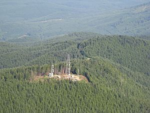
Some radio stations in the Seattle area have their transmitters on the west side of Tiger Mountain. These help send radio signals to many homes.
- KNKX 88.5
- KQMV 92.5
- KSWD 94.1
- KJAQ 96.5
- KIRO-FM 97.3
- KING-FM 98.1
- KNUC 98.9
- KISW 99.9
- KKWF 100.7
- KZOK-FM 102.5
- KHTP 103.7
- KBKS-FM 106.1
- KNDD 107.7
 | Precious Adams |
 | Lauren Anderson |
 | Janet Collins |


