Timber Trail facts for kids
Quick facts for kids Timber Trail |
|
|---|---|
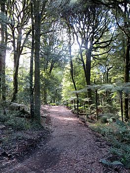
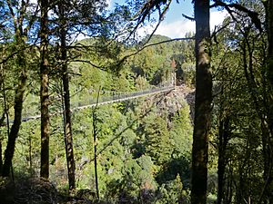
Above the Piropiro Valley; typical of the northern section of the Timber Trail
|
|
| Length | 84 km (52 mi) |
| Location | border of Waikato region and Manawatu-Wanganui region, New Zealand |
| Trailheads | Pureora and Ongarue |
| Use | Walking, cycling |
| Elevation change | 360 m (1,180 ft) |
| Highest point | 940 m (3,080 ft) |
| Lowest point | 200 m (660 ft) |
| Difficulty | Intermediate to easy |
| Season | Year round |
| Sights | Suspension bridges, railway spiral, native bush |
| Hazards | mud, trees, storms |
The Timber Trail is an amazing 84-kilometer path in New Zealand's North Island. It's perfect for biking, walking, and even hunting! This trail, also known as the Pureora Timber Trail, opened fully in 2013. It's part of the New Zealand Cycle Trail network.
Along the way, you'll cross 35 bridges, including 8 huge suspension bridges. These bridges are very strong and stable. The trail takes you through beautiful, ancient podocarp forests. You'll see giant rimu, totara, miro, matai, and kahikatea trees. You'll also ride through newer forests and areas where the bush is growing back.
About half of the trail follows an old railway line called the Ellis and Burnand Tramway. This old path includes a cool railway spiral and a tunnel!
Most people ride the Timber Trail over two days. It's best to start from Pureora (the northern end) and ride towards Ongarue. Even though there's a climb up to Mt Pureora, this direction is generally easier. If you're a very fit rider, you might even finish the trail in one day!
You can find places to stay and bike transport services along the trail. Options include Camp Epic, Pureora Cabins, Pa Harakeke, Timber Trail Lodge, and Blackfern Lodge. There's also a small hut called Bog Inn Hut, which is usually for walkers. It's about 2 kilometers off the main trail.
The trail officially ends in the historic village of Ongarue. This village has buildings that are over a hundred years old, made from native wood. Ongarue offers a campsite with toilets and picnic tables. You can also find places to stay like the Timber Trail Centre and Flashpackers.
Contents
How to Get to the Timber Trail
There are three main spots where you can start or join the Timber Trail:
- North: Pureora Village. Look for signs from SH30 between Te Kuiti and Mangakino.
- Centre: Piropiro campsite. This is at the end of Kokomiko Road in Waimiha.
- South: Ongarue. You'll see signs from SH4.
Exploring the Northern Timber Trail
This section goes from Pureora to Piropiro and is about 39.5 kilometers long. It's considered an intermediate (Grade 3) ride.
Pureora to the First Shelter
This part is about 8 kilometers long and is an easy (Grade 2) ride.
The trail starts near the DOC Pureora Field Base. You'll quickly turn left into the bush and ride on a boardwalk. For about 4 kilometers, you'll wind through tall podocarp trees. Keep an eye out for kaka birds! You'll cross Whareana Stream and go through a Douglas fir forest. The path then climbs through areas with regenerating plants like toitoi, cabbage tree, five finger, and kamahi. You'll cross Tui Road before reaching a shelter below Mt Pureora.
Mt Pureora to Angel's Rest
This section is about 15 kilometers long and is an intermediate (Grade 3) ride.
The trail climbs to 940 meters high. From here, you can walk for about 40 minutes to reach the summit of Mt Pureora, which is 1165 meters tall. You'll ride through different stages of regenerating bush until you reach the edge of the native forest. The trail then follows an old logging road.
You'll cross two large suspension bridges over streams that feed into the Ongarue River. These are the 115-meter Bog Inn Creek bridge and the similar-sized Orauhora crossing.
Angel’s Rest to Maramataha River
This part is about 17 kilometers long.
For about 6 kilometers, the trail uses an old logging road. Then, it mainly follows Okauaka Road. After crossing Okauaka Stream, the track joins an old tramway. It crosses Okauaka Road again and continues through the bush to Kokomiko Road and the Piropiro campground. After the campground, the track rejoins the tramway to Maramataha Road. Finally, a new track follows Piropiro Stream to the impressive Maramataha Bridge.
Exploring the Southern Timber Trail
This section goes from Piropiro to Ongarue and is about 43 kilometers long. It's considered an easy (Grade 2) ride.
Piropiro to Maramataha Bridge
This part is about 12 kilometers long and is an intermediate (Grade 3) ride.
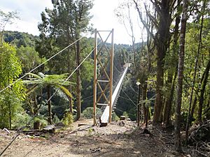
From the Piropiro campsite, you'll have a 30-minute climb to reach the 141-meter Maramataha Bridge. This bridge hangs about 60 meters above the Maramataha Gorge! It's the biggest suspension bridge of its kind on any cycle trail in New Zealand. Building it required a lot of rock drilling. The bridge is supported by tall wooden towers.
Maramataha River to Waione Stream
This section is about 12 kilometers long.
South of the Maramataha Bridge, you'll find the steepest climb on the trail. The path zigzags up to a flat area on a new track. From this flat area, old quad bike tracks lead to the northern end of the Ellis and Burnand Tramway, Ongarue tramway. The trail then mostly follows this old tramway, which has easier slopes, all the way to Ongarue. These old tramways were cleared in 2011 to make way for the trail.
Waione Stream to Goat Creek
This part is about 10 kilometers long.
You'll cross a 40-meter suspension bridge over Waione Stream. The tramway then continues to Waikoura Stream, passing old logging camps like No. 11 and No. 10. An information board tells you that Waikoura Camp (at No. 9) was the largest camp. It was built in 1950 and closed in 1963, with houses and huts for workers. You'll cross a 28-meter suspension bridge over Waikoura Stream. Another tramway links to the 90-meter Mangatukutuku suspension bridge. Then, the No. 7 tramway leads to Goat Creek.
Goat Creek to Ongarue Spiral
This section is about 9 kilometers long.
You'll cross Goat Creek on a curved wooden bridge that looks like the old tramway bridges. Then, you'll ride about 4 kilometers on a tramway cleared in 2011, which leads to the famous spiral.
The Ongarue Spiral was a clever way for the old tramway to climb 43 meters up a steep hill. This made it easier for the "bush lokeys" (small railway engines) to pull logs. Below the spiral, the tramway was built by cutting a path into the cliffs. The trail continues to drop until it reaches the bank of the Mangakahu Stream. The final 4 kilometers of the trail have gentle ups and downs. The trail ends in a car park next to Mangakahu Road, about 2 kilometers from Ongarue.
History of the Timber Trail
The Timber Trail cost about $5.5 million to build. It was one of the first "Quick Start" projects announced in 2009. These projects aimed to help the economy grow. The Timber Trail took a bit longer to finish than some other trails. It became the tenth New Zealand Cycle Trail to be completed.
In 2011, work began to restore the Ongarue Spiral. The tunnel was made stronger, and a stream that had been diverted into it was moved back out. The tunnel ceiling was reinforced with mesh. Parts of the original bridges were saved and included in the new trail bridge.
The Maramataha, Waione, and Waikoura bridges were tested in July 2011 to make sure they were safe. The Maramataha Bridge was finished in October 2012 and opened on November 1, 2012. The Bog Creek and Orauhora suspension bridges at the northern end were ready by December 2012.
On December 1, 2012, the southern section of the trail officially opened. About 150 cyclists rode across its four suspension bridges, the old tramline, and the Ongarue Spiral. The entire Timber Trail was declared fully open on Saturday, March 30, 2013, by the Minister of Conservation.
Even after the opening, improvements continued. In winter 2013, extra pumice was flown in by helicopter to fix muddy spots on the Mt Pureora section. More changes might happen in the future to make the trail even better.
Most of the southern part of the Timber Trail follows the old tramway built by J. W. Ellis and Harry Burnand. Their sawmill in Ongarue used this tramway to bring in logs, especially rimu trees. This went on from 1903 until floods damaged the lines in 1958. After that, the tramway was used by logging trucks until it closed in 1966. This old tramway is very important because it's one of the best-preserved examples of a bush tramway in the country.
Where to Stay on the Timber Trail
There are several places to stay near the Timber Trail, making it easy to find accommodation no matter which part of the trail you're exploring. These places are usually located at the start, end, or halfway point of the track.
Here are some of the accommodation options:
- Timber Trail Lodge
- Benneydale Lodge
- Pa Harakeke
- Camp Epic (camping/Glamping) at the 40km mark
- Waione River Homestead Waimiha
- Waitomo Lodge Te Kuiti
- Timber Trail Kohia – Former DOC Huts at Pureora
- Timber Trail Centre (Ongarue)
- Flashpackers (Ongarue)
In 2016, the government announced a grant to help develop an 80-bed lodge at Piropiro, which is the halfway point of the trail.
Images for kids
 | Georgia Louise Harris Brown |
 | Julian Abele |
 | Norma Merrick Sklarek |
 | William Sidney Pittman |


