Tin Brook facts for kids
Quick facts for kids Tin Brook |
|
|---|---|

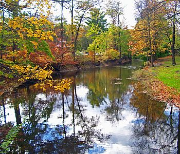
Tin Brook in Walden's Wooster Memorial Grove
|
|
| Country | United States |
| State | New York |
| County | Orange |
| Municipality | Town of New Windsor, Town of Montgomery, Village of Walden |
| Physical characteristics | |
| Main source | S of Coldenham 420 ft (130 m) 41°30′45″N 74°09′07″W / 41.51250°N 74.15194°W |
| River mouth | Wallkill River 260 ft (79 m) 41°34′31″N 74°11′26″W / 41.57528°N 74.19056°W |
| Length | 9 mi (14 km) |
| Basin features | |
| Basin size | 19.2 sq mi (50 km2) |
Tin Brook is a small river, about 9 miles (14 km) long, located in Orange County, New York, United States. It flows into the Wallkill River. Most of Tin Brook is found within the town of Montgomery. Near its end, it passes through the village of Walden.
Tin Brook is special because it's one of the few rivers that flows into the Wallkill River from the lowlands to the east, closer to the Hudson River. Most other rivers that join the Wallkill come from the Shawangunk Ridge in the west.
People have different ideas about where the name "Tin Brook" came from. Maps showed the name as early as 1774. One idea is that it was named after an early landowner called John Tinne or Tinbrook. Another idea suggests that Dutch settlers, who were the first Europeans in the area, named it. They might have used Dutch words meaning "thin breeches" because they thought the soil around the brook was too thin for their farming.
Contents
Where Does Tin Brook Start and Go?
Tin Brook begins in a large area of wetlands and vernal pools. This area is on the northern edge of Stewart State Forest, close to Interstate 84.
Journey Through Towns and Roads
Right after it starts, Tin Brook crosses into the town of Montgomery from New Windsor. It then quickly reaches NY 17K. The brook continues flowing north through quiet, mostly wooded areas. It bends slightly to the east and gets water from a small stream on its right.
It then reaches NY 52. Here, another stream joins it, and Tin Brook turns south, crossing the highway again. It makes a quick loop, turning north after passing a trailer park. Now wider, it crosses NY 52 once more between Berea and St. Andrew's roads.
Flowing Through Walden Village
Tin Brook then turns west and runs alongside the highway until it reaches the edge of Walden village. It turns south and crosses NY 52 for a third time in a neighborhood with homes. Here, it makes a long loop around Walden's Wooster Memorial Grove park. It gets so close to its own starting path that you can see it on both sides of the main entrance road near NY 52.
The brook then winds south through some light industrial areas. It crosses NY 52 for the last time a short distance east of the park. Finally, it turns west, running next to NY 52 (which is now West Main Street) for one block. Then it goes north, separating a residential area from a business property. In the woods north of the village, Tin Brook turns west one last time. It flows under NY 208 before emptying into the Wallkill River.
How Has Tin Brook Been Used?
Tin Brook has played a role in the history of the area, especially with transportation and power.
Early Canals and Transportation
In 1724, a man named Cadwallader Colden owned a large piece of land that included much of Tin Brook's starting area. He thought that New York's many rivers could be used to build canals. This would make it easier to move things around the colony. Colden decided to try this idea on his own land. He redirected some of Tin Brook's water into a pond. This pond then fed a short canal, which was the first canal ever built in New York. Small rafts on this canal carried peat (a type of fuel) and stone to build his house. They also moved other goods needed on his estate.
Providing Power for Walden
In 1892, Tin Brook helped provide water for Walden's first town electric company. This was a coal-fired power plant on Elm Street. At that time, only the mills on the Wallkill River made power, mostly for themselves. The Elm Street plant started giving power to the village in 1893.
Within 15 years, the village needed more power than the plant could make. As the knife-making factories along the Wallkill River started to slow down, they began providing power to the village. This eventually replaced the Elm Street plant.
After very heavy rains, Tin Brook can sometimes flood near where it joins the Wallkill River, especially around Wooster Grove park. For example, after Hurricane Irene in August 2011, the creek rose so high that most of the park was underwater. Some nearby streets also flooded, and the village of Walden had to close them. Further upstream, the intersection of Route 52 and St. Andrew's Road also had to be closed due to the high water.
What Animals Live Near Tin Brook?
Tin Brook is an important home for several animals that are considered "species of concern" in New York State. This means they need special protection.
Amphibians and Reptiles
- Salamanders: Three types of salamanders depend on the brook for their habitat:
- Bats: Indiana bats, which are a federally endangered species, use trees near the brook as places to rest during the day. They also look for food in the area around the brook.
- Turtles: Several types of turtles also live in and near Tin Brook:
 | William Lucy |
 | Charles Hayes |
 | Cleveland Robinson |


