
Togwotee Pass facts for kids
Quick facts for kids Togwotee Pass |
|
|---|---|

Togwotee Pass from north, from Breccia Peak, Two Oceans Mountain on the right
|
|
| Elevation | 9,658 ft (2,944 m) |
| Traversed by | U.S. Highway 287/U.S. Highway 26 |
| Location | Teton County, Wyoming, United States |
| Range | Absaroka Range |
Togwotee Pass (say it like "toe-GAH-tee") is a high mountain road. It sits on the Continental Divide in the Absaroka Mountains of the United States. This pass connects the towns of Dubois and Moran Junction in the Jackson Hole valley. It is about 9,655 feet (2,943 meters) high.
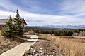
Two important roads, U.S. Highway 287 and U.S. Highway 26, cross Togwotee Pass. It is about 25 miles (40 km) east of Moran Junction. This pass is the easiest way to reach Grand Teton National Park if you are coming from eastern Wyoming. From the western side of the pass, you can see amazing views of the Teton Range. The pass is located between Two Ocean Mountain and Breccia Peak.
Contents
What is Togwotee Pass?
Togwotee Pass is a mountain pass, which is like a low point or gap in a mountain range. It makes it easier to travel from one side of the mountains to the other. This pass is also on the Continental Divide. This is a line that runs through the Americas. On one side, rivers flow toward the Atlantic Ocean. On the other side, rivers flow toward the Pacific Ocean.
The pass is part of the Bridger-Teton National Forest and is next to the Shoshone National Forest. These are large areas of protected land.
Winter Fun at Togwotee Pass
Togwotee Pass gets a lot of snow in winter. It is a very popular place for winter sports. People love to go snowmobiling and cross-country skiing here. The pass often gets more than 25 feet (760 cm) of snow each winter. Sometimes, it can even get over 50 feet (15 meters) of snow! Because of all this snow, the road can sometimes close for days during big snowstorms. The Continental Divide Snowmobile Trail also goes through this area.
History of Togwotee Pass
The pass is named after a person named Togwotee. He was a subchief of the Sheepeater tribe, which was a part of the Shoshone people. In 1873, Togwotee guided a group called The Jones Expedition over this pass.
Before this expedition, the pass was an important path for Native American tribes. They used it as a trade route to exchange goods.
Images for kids
-
The view of the Teton Range, looking west from Togwotee Pass

