
Breccia Peak (Wyoming) facts for kids
Quick facts for kids Breccia Peak |
|
|---|---|

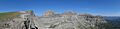
Breccia Peak (middle) from southwest, from US 26/US 287
|
|
| Highest point | |
| Elevation | 11,007 ft (3,355 m) |
| Prominence | 200 ft (61 m) |
| Parent peak | Buffalo Fork Peak |
| Geography | |

Breccia Peak
Location in Wyoming
|
|
| Location | Teton County, Wyoming, United States |
| Parent range | Absaroka Range, Rocky Mountains |
| Climbing | |
| Easiest route | Hike (YDS Class 2) |
Breccia Peak is a mountain found in the southern part of the Absaroka Range. This range is a large chain of mountains that are part of the bigger Rocky Mountains. Breccia Peak is located in Teton County, in the state of Wyoming, USA. It sits very close to the edge of the Teton Wilderness, which is inside the Bridger-Teton National Forest.
Contents
Where is Breccia Peak?
Breccia Peak is about 2.5 miles (4 km) north of Togwotee Pass. This pass is part of the Great Continental Divide. This important line separates rivers that flow to the Atlantic Ocean from those that flow to the Pacific. It connects the Jackson Hole area in the west to the Wind River valley in the east.
Breccia Peak's Unique Shape
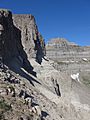
The top of Breccia Peak is somewhat flat, like a plateau. Its western and northern sides have steep, rocky cliffs called the Breccia Cliffs. However, the eastern and southern sides are mostly covered in grass.
Breccia Peak is the tallest mountain right in its immediate area. It stands about 200 feet (61 m) higher than Buffalo Fork Peak, which is to its north. Even taller mountains, like those in the Teton Range, are located further away, more than 30 miles (48 km) to the west.
Lost Lake Near Breccia Peak
About 1.25 miles (2 km) southwest of Breccia Peak, you can find Lost Lake. This lake is about 9,500 feet (2,900 m) high. It's a small but very beautiful lake. At certain times of the day, the tall Breccia Cliffs reflect perfectly in its calm waters.
What is Breccia Peak Made Of?
Breccia Peak is made of a special type of rock called volcanic Absaroka breccia. This is a kind of rock that forms from broken pieces of minerals and other rocks that get stuck together. The mountain actually gets its name from this unique rock!
The rocks at the very top of the mountain are part of something called the Wiggins Formation. These rocks were formed a very long time ago, during the Eocene epoch. This was a period in Earth's history when many volcanoes were active in this region.
Climbing Breccia Peak
Breccia Peak is a popular spot for hikers and climbers in the Yellowstone Region. It's quite easy to get to. You can usually reach the top in about two hours from a starting point near U.S. Highway 26/U.S. Highway 287. This trailhead is about 0.6 miles (1 km) north of Togwotee Pass.
Hiking the Trails
The path to the top is challenging but not too dangerous. It's rated as a YDS Class 2 hike, which means it might involve some easy scrambling. There's a clear, but unofficial, trail that leads from the start point up to where the trees stop. Early on, the trail splits: the left path goes to Breccia Peak, and the right path goes to Sublette Peak.
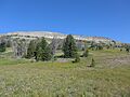
When you reach about 10,000 feet (3,000 m) in elevation, you'll find a large open meadow southeast of Breccia Peak. From here, you can see the entire southeast side of the mountain.
Routes to the Summit
The easiest way to climb Breccia Peak is to walk across the southeast side of the mountain to reach the east ridge. This helps you avoid a very steep, rocky cliff in the middle. Once on the east ridge, you can follow it all the way to the top. Another option is to go across the southwest side of the mountain to the south ridge, and then follow that ridge to the summit.
The southeast side of the mountain, above the treeline, is also a great place for backcountry skiing. The ski runs here are short but offer a lot of variety for skiers.
Images for kids
-
Breccia Peak (left) and Buffalo Fork Peak (right) from the east ridge of Breccia Peak.
-
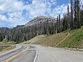
Breccia Peak from the pullout 0.6 miles north of Togwotee Pass, showing the start of the track.
-
Breccia Peak from the southeast while ascending on the normal route. The steep cliff in the middle can be passed on the left or on the right.
-
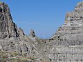
The northern cliffs of Breccia Peak.
-
The first low point (col) between Breccia Peak (left) and Buffalo Fork Peak, with Mount Moran in the background.
-
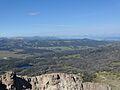
A view from Breccia Peak looking west towards the Teton Range, with Lost Lake in the foreground.
-
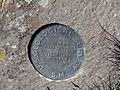
A Survey marker at the very top of Breccia Peak.


