Touchet, Washington facts for kids
Quick facts for kids
Touchet, Washington
|
|
|---|---|
 |
|

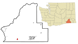
Location of Touchet, Washington
|
|
| Country | United States |
| State | Washington |
| County | Walla Walla |
| Area | |
| • Total | 1.2 sq mi (3.1 km2) |
| • Land | 1.2 sq mi (3.1 km2) |
| • Water | 0.0 sq mi (0.0 km2) |
| Elevation | 443 ft (135 m) |
| Population
(2020)
|
|
| • Total | 425 |
| • Density | 354/sq mi (137.1/km2) |
| Time zone | UTC-8 (Pacific (PST)) |
| • Summer (DST) | UTC-7 (PDT) |
| ZIP code |
99360
|
| Area code | 509 |
| FIPS code | 53-72030 |
| GNIS feature ID | 1509053 |
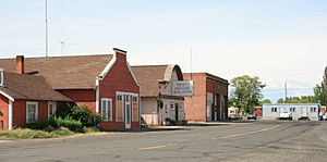
Touchet (pronounced TOO-shee) is a small community in Walla Walla County, Washington, in the United States. It is known as a census-designated place (CDP), which means it's an area identified by the U.S. Census Bureau for statistical purposes, but it's not an officially incorporated town or city with its own local government. In 2020, about 425 people lived there.
Contents
History of Touchet
Early Days and Native American Heritage
Before settlers arrived, the area near Touchet was home to a village of the Walla Walla people. They called this place Tuushi. This name means "baking salmon on sticks over coals." It comes from an old story about a coyote.
Other Native American groups, like the Palouse, Yakamas, Umatilla, and Wanapum, also used this land. When explorers Lewis and Clark traveled through the Walla Walla Valley in 1806, they called these groups "Nez Perce."
Settlers Arrive and Challenges
In the early 1850s, people from the eastern United States started to move into the valley. However, they soon left because of conflicts with the Native American people. This period included events like the Yakima War.
New settlers returned to the valley in 1859. They began to build farms and homes.
The Railroad Comes to Town
The Walla Walla & Columbia River Railroad was a big project. It was planned to connect Wallula to Walla Walla. By March 1874, 16 miles of track were finished, reaching Touchet.
This railroad was very important for the farmers in Touchet. By the end of 1874, farmers shipped out 4,000 tons of wheat using the train. They also received 1,100 tons of goods and supplies.
Touchet has always remained a CDP. It has never become an officially incorporated town.
Geography and Climate
Location and Size
Touchet is located in southeastern Washington state. It sits at coordinates 46.039402 degrees North and -118.670971 degrees West.
The community covers a total area of about 1.2 square miles (3.1 square kilometers). All of this area is land.
Weather in Touchet
Touchet has a type of weather known as a warm-summer Mediterranean climate. This means it usually has hot, dry summers and mild, wet winters. On climate maps, this is often shown as "Csa."
People of Touchet
Population Over Time
The number of people living in Touchet has slowly grown over the years:
- In 2000, there were 396 people.
- In 2010, the population increased to 421 people.
- By 2020, there were 425 residents.
Who Lives Here?
In 2000, there were 396 people living in Touchet. These people lived in 135 households, and 112 of those were families. The community had about 326 people per square mile.
Most of the people in Touchet were White (about 92.68%). Some residents were Native American (0.76%) or from other backgrounds. About 15.66% of the population identified as Hispanic or Latino.
Many households (48.1%) had children under 18 living with them. Most households (71.9%) were married couples. The average household had about 2.93 people.
Age and Income
The population of Touchet in 2000 included people of all ages. About 34.6% were under 18 years old. About 8.6% were 65 years or older. The average age was 34 years.
The typical income for a household in Touchet was $37,500 per year. For families, the median income was $50,278. About 13.4% of all people in Touchet lived below the poverty line. This included 18.8% of children under 18 and 27.0% of people aged 65 or older.
See also
 In Spanish: Touchet (Washington) para niños

