Tower, Michigan facts for kids
Quick facts for kids
Tower, Michigan
|
|
|---|---|
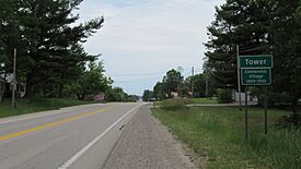
Road signage looking east along M-33/M-68
|
|
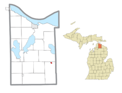
Location within Cheboygan County
|
|
| Country | United States |
| State | Michigan |
| County | Cheboygan |
| Township | Forest |
| Settled | 1899 |
| Area | |
| • Total | 0.61 sq mi (1.58 km2) |
| • Land | 0.54 sq mi (1.40 km2) |
| • Water | 0.07 sq mi (0.18 km2) |
| Elevation | 728 ft (222 m) |
| Population
(2020)
|
|
| • Total | 248 |
| • Density | 459.26/sq mi (177.32/km2) |
| Time zone | UTC-5 (Eastern (EST)) |
| • Summer (DST) | UTC-4 (EDT) |
| ZIP code(s) |
49765 (Onaway)
|
| Area code(s) | 989 |
| GNIS feature ID | 1614982 2806319 |
Tower is a small community in Cheboygan County, Michigan. It's a place where people live, but it doesn't have its own local government. In 2020, about 248 people lived there. Tower is located where two main roads, M-33 and M-68, meet. It's part of Forest Township.
Contents
Exploring Tower, Michigan
Where is Tower Located?
Tower is a quiet, rural community in Northern Michigan. It's in the northern part of Forest Township. The community sits about 722 feet (220 meters) above sea level.
The main roads passing through Tower are M-33 and M-68. These roads run together for a while. Interstate 75 is about 16 miles (26 km) to the west. Another important road, F-05, starts just east of Tower. It goes northwest for about 24.5 miles (39.4 km) to the city of Cheboygan.
Tower is quite isolated, meaning it's the only community in Forest Township. Nearby communities include Afton and Onaway. Onaway is about 4 miles (6.4 km) east in Presque Isle County.
Rivers, Lakes, and Trails
Tower is located along the Upper Black River. This part of the river has two dams that create electricity: the Kleber Dam and the Tower Dam. Each dam forms its own lake. Tower Pond is 102 acres (41 hectares) big, and the community is mostly built around it. Kleber Pond is larger, about 267–295 acres (108–119 hectares), and is north of Tower.
Both ponds are great for fishing. There's a small boat launch near the township hall for Tower Pond. A small stream called Bowen Creek flows into the Black River in Tower. The large Black Lake is about 5 miles (8.0 km) north. Parts of the nearby forests are part of the Mackinaw State Forest.
The North Eastern State Trail is a special path that used to be a railroad. It goes through Tower and has a starting point near the Tower Dam. This trail is 70 miles (110 km) long and runs from Alpena to Cheboygan.
Community Services
The Forest Township Hall is in the center of Tower. Right next to it is the Forest–Waverly Fire Department. This fire department is run by volunteers and helps both Forest Township and Waverly Township.
Children in Tower go to school in the Onaway Area Community School District. Tower used to have its own post office, but now mail services come from Onaway, using the 49765 ZIP Code.
Tower's Past: A Lumber Town
How Tower Began
Tower started around 1899. This was when the Detroit and Mackinac Railway built a train line through the area. A small community grew up along the Black River, focused on cutting down trees for wood (lumber).
A post office opened in Tower on April 18, 1899. The community was named after Ellen May Tower. She was the daughter of a local judge and a nurse in the Spanish–American War. Sadly, Ellen died in Puerto Rico in 1898 from an illness. She was the first American servicewoman to die during a war in a foreign country. Her funeral in Byron, Michigan, was a very big event.
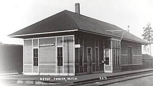
Tower was officially planned out on May 20, 1899. It became a key place for lumber because of the new railroad and its location on the Black River. Logs could easily be floated down the river to sawmills. By 1901, Tower had two sawmills and about 300 people. The railroad built a train station in 1902, which helped the town grow even more.
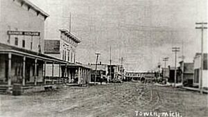
In the early 1900s, Tower had many businesses. These included hotels, banks, markets, and even a fire department with a horse-drawn fire truck! For a short time, from 1905–1906, Tower even had its own newspaper called The Tower Press. In 1908, a forest fire destroyed some buildings in Tower.
By 1910, Tower had its largest population, with 800 residents. It had several churches, a school, five sawmills, and many other businesses. The Tower Dam was built that same year. This new dam created Tower Pond, which helped move lumber to the train station. In winter, ice was also collected from the pond. Tower also got telephone service around this time.
A Time of Challenges
In July 1911, a huge series of forest fires, known as the Au Sable–Oscoda Fire, swept through the region. These fires spread quickly because of hot weather and dry wood. People in Tower saw the danger and quickly left the town. Many brave men stayed behind to try and save buildings and railroad equipment.
Tower suffered a lot of damage, but it wasn't completely destroyed thanks to their efforts. Still, the train station, many mills, and other buildings were lost. After this fire, Tower's lumber industry never fully recovered. Many lumber companies moved away. By 1916, Tower's population had dropped to 300.
In April 1922, Tower faced another challenge: severe flooding. Heavy snow and ice melted quickly, causing the Black River to overflow. The Tower Dam was in danger of breaking, and about 500 feet (150 meters) of railroad tracks were washed away. Many men worked hard to clear debris and protect the dam. Even though the dam and railroad bridge were weakened, they held. However, a train later derailed because of the damaged tracks. In 1924, the Detroit and Mackinac Railway stopped its train service in Tower.
Tower Today
New Roads and Changes
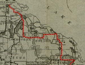
Even without train service, Tower found new ways to connect. In 1926, U.S. Route 23 (US 23) was built right through Tower. This road connected Tower to Mackinaw City to the north and even to Ohio in the south. During the 1920s, the lumber business ended in Tower. The community then became a farming area and a stop for travelers on US 23.
In 1940, US 23 was moved to run closer to Lake Huron, so it no longer went through Tower. The old part of US 23 through Tower became part of M-33. In 1946, it also became part of M-68. So, Tower continued to benefit from travelers on these two state highways.
In 1949, the Kleber Dam was finished. Both the Kleber Dam and the Tower Dam still work today, helping to control floods and produce electricity. In 1970, F-05 was created. This road starts east of Tower and goes to Cheboygan, giving people another way to get around.
Trails and Recent Times
The old railroad lines in Tower were used until 1992. After that, the tracks were removed. By 2011, the state of Michigan turned the old railway into the North Eastern State Trail. This multi-use trail is great for walking, biking, and other activities. It runs for 70 miles (110 km) from Alpena to Cheboygan. There's a trailhead in Tower near the Tower Dam.
In 2007, a tornado touched down just west of Tower. It traveled northeast towards Black Lake. This was one of many tornadoes that happened during a large storm event.
For the 2020 census, Tower was officially listed as a census-designated place (CDP). This means it's a specific area counted for statistics, but it still doesn't have its own local government. Tower remains a small, unincorporated community.
 | Charles R. Drew |
 | Benjamin Banneker |
 | Jane C. Wright |
 | Roger Arliner Young |


