Onaway, Michigan facts for kids
Quick facts for kids
Onaway, Michigan
|
|
|---|---|

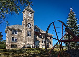
Presque Isle County Courthouse
|
|

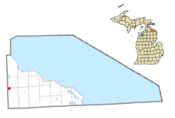
Location within Presque Isle County
|
|
| Country | United States |
| State | Michigan |
| County | Presque Isle |
| Incorporated | 1899 (village) 1903 (city) |
| Government | |
| • Type | City council |
| Area | |
| • Total | 1.63 sq mi (4.22 km2) |
| • Land | 1.63 sq mi (4.22 km2) |
| • Water | 0.00 sq mi (0.00 km2) |
| Elevation | 850 ft (259 m) |
| Population
(2020)
|
|
| • Total | 890 |
| • Density | 546.35/sq mi (210.95/km2) |
| Time zone | UTC-5 (Eastern (EST)) |
| • Summer (DST) | UTC-4 (EDT) |
| ZIP code(s) |
49765
|
| Area code(s) | 989 |
| FIPS code | 26-60680 |
| GNIS feature ID | 0634060 |
Onaway (pronounced ON-uh-way) is a small city in Presque Isle County, Michigan, in the United States. It's located just east of the border with Cheboygan County. In 2020, about 890 people lived there. Onaway is known as the "Sturgeon Capital of Michigan." This is because there's a special facility nearby on the Black River that helps raise young lake sturgeon. These fish then travel to the Cheboygan River and eventually to Lake Huron.
Contents
History of Onaway
Onaway started as a farming community. It first got a post office on October 23, 1882. This office was named "Shaw" after Thomas E. Shaw, who was a civil engineer and the first postmaster.
In 1886, a man named Merritt Chandler planned out the community and called it Onaway. He later became the postmaster, and the post office officially changed its name to Onaway on March 29, 1890. For a short time, the post office name changed back to "Adalaska" in 1893, but it was renamed Onaway again on November 15, 1897.
Onaway became an official village in 1899. Just a few years later, in 1903, it grew and became a city. At the start of the 1900s, Onaway was a very important place for making wooden automobile steering wheels. It produced about 65% of all the wooden steering wheels in the world!
Geography and Location
Onaway covers an area of about 1.57 square miles (4.22 square kilometers), and all of it is land. The border between Cheboygan and Presque Isle counties is just to the west of the city.
Main Roads
Several state highways pass through or near Onaway:
 M-33
M-33 M-68
M-68- M-211
Population Changes
| Historical population | |||
|---|---|---|---|
| Census | Pop. | %± | |
| 1900 | 1,204 | — | |
| 1910 | 2,702 | 124.4% | |
| 1920 | 2,789 | 3.2% | |
| 1930 | 1,492 | −46.5% | |
| 1940 | 1,449 | −2.9% | |
| 1950 | 1,421 | −1.9% | |
| 1960 | 1,388 | −2.3% | |
| 1970 | 1,262 | −9.1% | |
| 1980 | 1,084 | −14.1% | |
| 1990 | 1,039 | −4.2% | |
| 2000 | 993 | −4.4% | |
| 2010 | 880 | −11.4% | |
| 2020 | 890 | 1.1% | |
| U.S. Decennial Census | |||
According to the 2010 census, there were 880 people living in Onaway. The city had 394 households. The average age of people in Onaway was about 43.6 years old. About 23% of the residents were under 18, and nearly 20% were 65 or older.
Local Media
People in Onaway can access various news and entertainment options.
Newspapers
- The Alpena News is a daily newspaper that covers much of northeastern Michigan.
- The Onaway Outlook is a weekly newspaper specifically for the city of Onaway.
- The Presque Isle County Advance is another weekly newspaper for the wider Presque Isle County area.
Television Channels
Several TV channels are available in Onaway, bringing news and shows from different networks:
- Channel 4: WTOM-TV ("TV 7&4" - NBC)
- Channel 6: WCML ("CMU Public Television" - PBS)
- Channel 8: WGTQ ("ABC 29&8" - ABC)
- Channel 10: WWUP-TV ("9&10 News" - CBS)
- Channel 11: WBKB-TV ("Channel 11 News" - CBS)
Radio Stations (FM)
| Call Sign | Frequency | City Broadcast From |
|---|---|---|
| WTLI | 89.3 | Bear Creek Township |
| WPHN | 90.5 | Gaylord |
| WCML | 91.7 | Alpena |
| WFDX | 92.5 | Atlanta |
| WBCM | 93.5 | Boyne City |
| WKJZ | 94.9 | Hillman |
| WLXT | 96.3 | Petoskey |
| WRGZ | 96.7 | Rogers City |
| WAWM | 98.9 | Petoskey |
| WHAK | 99.9 | Rogers City |
| WMJZ | 101.5 | Gaylord |
| WMKC | 102.9 | Indian River |
| WGFM | 105.1 | Cheboygan |
| WHSB | 107.7 | Alpena |
Radio Stations (AM)
| Call Sign | Frequency | City Broadcast From |
|---|---|---|
| WTCM | 580 | Traverse City |
| WOUF | 750 | Petoskey |
| WHAK | 960 | Rogers City |
| WWMN | 1110 | Petoskey |
Transportation
Onaway has access to several ways to get around.
Airports
The Leo E. Goetz County Airport is now closed. For commercial flights, people in Onaway can use nearby airports like:
- Alpena County Regional Airport
- Cherry Capital Airport in Traverse City
- Pellston Airport
Roads and Trails
- Michigan State Trunklines:
 M-33
M-33 M-68
M-68- M-211 (This road starts in Onaway)
- Michigan Department of Natural Resources trails:
- North Eastern State Trail
See also
 In Spanish: Onaway (Míchigan) para niños
 | Emma Amos |
 | Edward Mitchell Bannister |
 | Larry D. Alexander |
 | Ernie Barnes |


