Tower Rock State Park facts for kids
Quick facts for kids Tower Rock State Park |
|
|---|---|
|
IUCN Category III (Natural Monument)
|
|
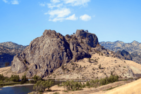
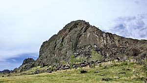
Tower Rock, southeast side
|
|
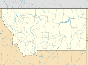
| Location | Cascade County, Montana, U.S. |
| Nearest city | Cascade, Montana, U.S. |
| Area | 140 acres (0.57 km2) |
| Designated | February 2004 |
| Visitors | 11,496 (in 2016) |
| Governing body | Montana Department of Fish, Wildlife and Parks |
| Website | stateparks.mt.gov/tower-rock |
|
Tower Rock
|
|
| Area | 87.2 acres (0.353 km2) |
| NRHP reference No. | 02000213 |
| Added to NRHP | March 18, 2002 |
Tower Rock State Park is a special place in Montana, USA. It's a state park located near the town of Cascade. The main attraction is Tower Rock, a huge rock formation that stands 424-foot (129 m) tall. This rock marks the start of the Missouri River Canyon.
Long ago, Native Americans knew about Tower Rock. The Piegan Blackfeet people thought it was a sacred, or very special, place. In 1805, Meriwether Lewis of the Lewis and Clark Expedition saw the rock and gave it its modern name. Even with railroads and highways built later, Tower Rock itself stayed untouched. The area around Tower Rock became a protected site in 2002. Then, in 2004, the larger Tower Rock State Park was created.
Contents
What is Tower Rock?
Tower Rock is part of the Adel Mountains Volcanic Field. This area has very old volcanic rock, about 75 million years old. Tower Rock itself is made of a hard rock called shonkinite. As the softer rocks around it wore away over time, the shonkinite remained, forming the tall rock you see today.
The rock is shaped like a long oval and is about 424-foot (129 m) high. It has two main peaks connected by a lower ridge. The southern peak is taller than the northern one. At its highest point, Tower Rock is 3,976 feet (1,212 m) above sea level. The east side of the rock is covered in loose rocks and debris. The flat areas around Tower Rock used to be old paths of the Missouri River. You can find juniper trees, fir trees, grasses, and sagebrush growing around its base. The south side of Tower Rock is right next to the Missouri River, with a steep rock face.
History of Tower Rock
Native Americans and Early Explorers
A very long time ago, during the last glacial period, Tower Rock was mostly underwater. Huge ice sheets blocked the Missouri River, creating a large lake called Lake Great Falls. Only about 15 feet (4.6 m) of Tower Rock was visible above the water!
Native Americans knew Tower Rock very well. The Bitterroot Salish and Lower Kootenay people often traveled past it. The Piegan Blackfeet people frequently stayed near present-day Helena, Montana, and used the Missouri River path. They built simple shelters called wickiups in the area, which they reused. The Piegan Blackfeet believed Tower Rock was sacred. They held ceremonies there, and individuals would visit for prayer and quiet thought.
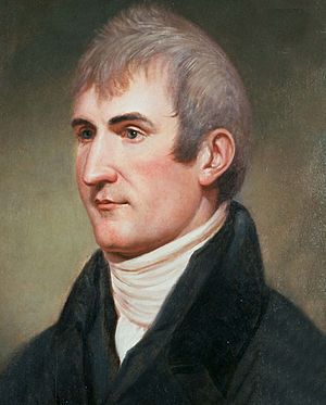
Tower Rock got its modern name from Meriwether Lewis on July 16, 1805. For the Lewis and Clark Expedition, Tower Rock was an important landmark. It showed them where the Great Plains ended and the Rocky Mountains began. After carrying their boats around the Great Falls of the Missouri, the expedition continued their journey. Lewis and two other members, Jean Baptiste Lepage and John Potts, walked ahead to explore. They followed a Native American trail and saw Tower Rock that afternoon. Lewis wrote in his journal that he called it "the tower." He noted its height and how it stood alone near the river. He also saw many buffalo in the plains below from the rock.
Another member of the expedition, Sergeant John Ordway, saw Tower Rock in 1806. His group was traveling down the Missouri River. Strong winds and waves made it hard for them to pass the rock, so they had to stop for the night nearby.
Railroads and Roads
For many years after Lewis and Clark, not many white settlers came to the Missouri River canyon. This was partly because there were easier routes to other areas. Also, the Piegan Blackfeet people still lived there and protected their land.
Later, roads and railroads were built. The Mullan Road, built in 1859-1860, went around Tower Rock. It avoided the rugged volcanic mountains. In 1885, the St. Paul, Minneapolis & Manitoba Railway (which became part of the Great Northern Railway) decided to build a railroad through the Missouri River canyon. This railroad line went right between Tower Rock and the river. Workers had to blast away some rock at the base of Tower Rock to make space for the tracks. The railroad opened in 1887.
A small town called Hardy grew up near Tower Rock in 1888. It was a stop for the railroad. However, due to economic problems in the 1920s and 1930s, the town almost disappeared.
The first road past Tower Rock wasn't built until 1932. This road, which became part of Highway 91, followed the west bank of the Missouri River. It largely ran next to the railroad tracks. The road went around Tower Rock to the west. This highway offered amazing views of the area.
In the 1960s, Interstate 15 (I-15) was built. It followed a similar path to Highway 91 through the canyon. I-15 passed Tower Rock to the east. This new, wider highway opened in 1968.
About the Park Today
How the Park Was Created
Tower Rock has been part of many different lands over time. It was claimed by Native Americans, then by European countries, and finally became part of the United States in 1803.
Over the years, parts of the land around Tower Rock were owned by different people and companies. In 1957, the Montana Department of Transportation (MDOT) bought some of the land for the new I-15 highway. However, since the highway went east of Tower Rock, this land wasn't used. MDOT tried to sell it later, but local people wanted to keep it protected.
Because of public interest, Tower Rock was added to the National Register of Historic Places in 2002. In 2004, the MDOT officially gave the land to the Montana Department of Fish, Wildlife and Parks. This created the 140-acre (0.57 km2) Tower Rock State Park.
Visiting Tower Rock State Park
Tower Rock State Park is about 30 miles (48 km) south of Great Falls. You can get there from Interstate 15 at exit 247. The park is at the start of the Missouri River Canyon, which is about 60-mile (97 km) long.
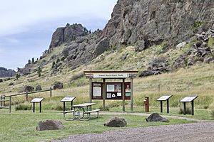
The park looks much like it did when Lewis and Clark first saw it in 1805. When it became a state park in 2004, there were no special facilities. But by 2016, a parking lot and signs were added at the north end. There's also a 0.25-mile (0.40 km) trail that leads from the parking lot towards the middle of the rock formation. You can only visit Tower Rock State Park during daylight hours.
Many people visit Tower Rock State Park. In 2016, over 11,000 people came to see this historic and natural wonder.
 | Emma Amos |
 | Edward Mitchell Bannister |
 | Larry D. Alexander |
 | Ernie Barnes |


