
Travelers Rest, South Carolina facts for kids
Quick facts for kids
Travelers Rest
|
||
|---|---|---|

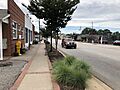
U.S. Route 276 in Travelers Rest
|
||
|
|
||
| Nickname(s):
TR, Gateway to the Foothills
|
||
| Motto(s):
"Get in Your Element"
|
||

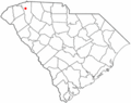
Location of Travelers Rest, South Carolina
|
||
| Country | United States | |
| State | South Carolina | |
| County | Greenville | |
| Government | ||
| • Type | Council | |
| Area | ||
| • Total | 6.33 sq mi (16.40 km2) | |
| • Land | 6.24 sq mi (16.16 km2) | |
| • Water | 0.09 sq mi (0.24 km2) | |
| Elevation | 1,099 ft (335 m) | |
| Population
(2020)
|
||
| • Total | 7,788 | |
| • Density | 1,247.88/sq mi (481.82/km2) | |
| Time zone | UTC−5 (Eastern (EST)) | |
| • Summer (DST) | UTC−4 (EDT) | |
| ZIP Code |
29690
|
|
| Area code(s) | 864, 821 | |
| FIPS code | 45-72430 | |
| GNIS feature ID | 1251197 | |
Travelers Rest is a city in Greenville County, South Carolina. In 2020, about 7,788 people lived there. It is part of the larger Greenville-Mauldin-Easley area.
Travelers Rest is the city furthest north in Greenville County. It is about 10 miles north of Greenville. It is also about 20 miles south of the North Carolina border. Two universities are near the city. Furman University became part of Travelers Rest in 2018. North Greenville University is in nearby Tigerville.
Contents
History of Travelers Rest
How Travelers Rest Got Its Name
In 1794, the government of South Carolina decided to build a road. This road would go from Greenville north into the Blue Ridge Mountains. It would pass through Asheville, North Carolina, and end in East Tennessee.
By the mid-1850s, this road was finished. Many wagons used it. If you were traveling north from the coast, Travelers Rest was the first good place to stop. Here, people could get ready for the big climb into the mountains. This is how the city got its name, as a "rest" stop for "travelers."
Becoming a City
Travelers Rest officially became a city in 1959. Before that, it was also a city in 1891, but that status ended. For many years in the 1800s and early 1900s, the area was known as Bates Township.
Historic Buildings and People
Two important old houses are in Travelers Rest. They are the John H. Goodwin House and the George Salmon House. Both are listed on the National Register of Historic Places. This means they are special historical sites.
A famous American Revolutionary War hero, Dicey Langston, lived near here. Her home is now marked with a historical sign.
Getting Around Travelers Rest
Main Roads and Highways
U.S. Route 276-N connects downtown Greenville to Travelers Rest. It becomes the main street in the city. Then, it heads northwest past Caesar's Head State Park. It continues into North Carolina, reaching Brevard.
U.S. Route 25-N also comes into the city. It then turns north into the Blue Ridge Mountains. This road connects Travelers Rest to Asheville, which is about 54 miles away.
City Area
In 2010, the city covered about 11.8 square kilometers (4.5 square miles). Only a very small part of this area, about 0.54%, was water.
Weather in Travelers Rest
The weather in Travelers Rest changes throughout the year. Summers are warm, and winters are cool.
| Climate data for Travelers Rest, SC | |||||||||||||
|---|---|---|---|---|---|---|---|---|---|---|---|---|---|
| Month | Jan | Feb | Mar | Apr | May | Jun | Jul | Aug | Sep | Oct | Nov | Dec | Year |
| Mean daily maximum °F (°C) | 51.1 (10.6) |
55.0 (12.8) |
62.8 (17.1) |
72.3 (22.4) |
79.9 (26.6) |
85.6 (29.8) |
88.3 (31.3) |
87.4 (30.8) |
81.5 (27.5) |
72.3 (22.4) |
62.4 (16.9) |
53.1 (11.7) |
71.0 (21.7) |
| Daily mean °F (°C) | 40.5 (4.7) |
43.5 (6.4) |
50.7 (10.4) |
59.4 (15.2) |
67.6 (19.8) |
74.1 (23.4) |
77.4 (25.2) |
76.6 (24.8) |
70.5 (21.4) |
59.9 (15.5) |
50.5 (10.3) |
42.6 (5.9) |
59.4 (15.3) |
| Mean daily minimum °F (°C) | 30.0 (−1.1) |
32.0 (0.0) |
38.7 (3.7) |
46.4 (8.0) |
55.4 (13.0) |
62.8 (17.1) |
66.6 (19.2) |
65.8 (18.8) |
59.7 (15.4) |
47.7 (8.7) |
38.8 (3.8) |
32.4 (0.2) |
48.0 (8.9) |
People Living in Travelers Rest
Population Growth Over Time
The number of people living in Travelers Rest has grown a lot over the years.
| Historical population | |||
|---|---|---|---|
| Census | Pop. | %± | |
| 1960 | 1,973 | — | |
| 1970 | 2,241 | 13.6% | |
| 1980 | 3,017 | 34.6% | |
| 1990 | 3,069 | 1.7% | |
| 2000 | 4,099 | 33.6% | |
| 2010 | 4,576 | 11.6% | |
| 2020 | 7,788 | 70.2% | |
| 2023 (est.) | 8,750 | 91.2% | |
| U.S. Decennial Census | |||
Who Lives in Travelers Rest?
The 2020 census counted 7,788 people in the city. There were 1,751 households, which are groups of people living together. There were also 1,171 families.
The table below shows the different groups of people living in Travelers Rest in 2020.
| Race | Num. | Perc. |
|---|---|---|
| White (not Hispanic or Latino) | 6,004 | 77.09% |
| Black or African American (not Hispanic or Latino) | 879 | 11.29% |
| Native American | 16 | 0.21% |
| Asian | 151 | 1.94% |
| Pacific Islander | 4 | 0.05% |
| Other/Mixed | 343 | 4.4% |
| Hispanic or Latino | 391 | 5.02% |
Education in Travelers Rest
Travelers Rest has good schools and learning places. Furman University is located just south of the city. The city is also home to the Travelers Rest High School. Their sports teams are called the Devildogs.
The city also has a public library. It is a part of the Greenville County Library System.
Images for kids
-
U.S. Route 276 in Travelers Rest
-

Travelers Rest City Logo
-
Location of Travelers Rest, South Carolina
See also
 In Spanish: Travelers Rest para niños
