Trenton, Georgia facts for kids
Quick facts for kids
Trenton, Georgia
|
|||
|---|---|---|---|
| City of Trenton | |||

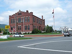
Dade County Courthouse, Trenton, 2009.
|
|||
|
|||

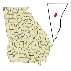
Location in Dade County and the state of Georgia
|
|||
| Country | |||
| State | |||
| County | Dade | ||
| Founded | 1830s | ||
| Incorporated | February 18, 1854 | ||
| Named for | Trenton, New Jersey | ||
| Government | |||
| • Type | Mayor-Council | ||
| Area | |||
| • Total | 3.22 sq mi (8.33 km2) | ||
| • Land | 3.22 sq mi (8.33 km2) | ||
| • Water | 0.00 sq mi (0.00 km2) | ||
| Elevation | 758 ft (231 m) | ||
| Population
(2020)
|
|||
| • Total | 2,195 | ||
| • Density | 682.52/sq mi (263.56/km2) | ||
| Time zone | UTC-5 (EST) | ||
| • Summer (DST) | UTC-4 (EDT) | ||
| ZIP code(s) |
30752
|
||
| Area code(s) | 706, 762 | ||
| FIPS code | 13-77372 | ||
| GNIS feature ID | 0333261 | ||
Trenton is a city in Dade County, Georgia, United States. It is the only city in Dade County. This means it is the main town and the county seat. In 2020, about 2,195 people lived there. Trenton is also part of the larger Chattanooga, Tennessee area.
Contents
History of Trenton
Trenton was started in the 1830s. It was first called Salem. In 1839, Salem became the main town for the new Dade County. The name was changed to Trenton in 1841. The city was named after Trenton, which is the capital city of New Jersey.
Geography of Trenton
Trenton is located in the northwestern part of Georgia. Its exact location is 34°52′32″N 85°30′31″W / 34.87556°N 85.50861°W.
The city is near Interstate 59. This highway goes northeast about 20 miles (32 km) to Chattanooga. It also goes southwest about 128 miles (206 km) to Birmingham, Alabama.
Other important roads include U.S. Route 11 and Georgia State Route 136. U.S. 11 also goes to Chattanooga and Fort Payne, Alabama. GA-136 connects Trenton to LaFayette and the Alabama state line.
The United States Census Bureau says Trenton covers about 3.1 square miles (8.0 km2) of land. There is no water area within the city limits.
Population and People
| Historical population | |||
|---|---|---|---|
| Census | Pop. | %± | |
| 1870 | 223 | — | |
| 1880 | 255 | 14.3% | |
| 1890 | 378 | 48.2% | |
| 1900 | 349 | −7.7% | |
| 1910 | 302 | −13.5% | |
| 1920 | 295 | −2.3% | |
| 1930 | 370 | 25.4% | |
| 1940 | 570 | 54.1% | |
| 1950 | 755 | 32.5% | |
| 1960 | 1,301 | 72.3% | |
| 1970 | 1,523 | 17.1% | |
| 1980 | 1,682 | 10.4% | |
| 1990 | 1,994 | 18.5% | |
| 2000 | 1,942 | −2.6% | |
| 2010 | 2,301 | 18.5% | |
| 2020 | 2,195 | −4.6% | |
| U.S. Decennial Census 1850-1870 1870-1880 1890-1910 1920-1930 1940 1950 1960 1970 1980 1990 2000 2010 |
|||
Trenton's Population in 2020
| Race | Num. | Perc. |
|---|---|---|
| White (non-Hispanic) | 1,984 | 90.39% |
| Black or African American (non-Hispanic) | 18 | 0.82% |
| Native American | 8 | 0.36% |
| Asian | 18 | 0.82% |
| Other/Mixed | 104 | 4.74% |
| Hispanic or Latino | 63 | 2.87% |
In 2020, the city had 2,195 people. There were 1,025 households and 700 families living in Trenton.
Trenton's Population in 2010
In 2010, Trenton had 2,301 people. There were 904 households. About 31.6% of households had children under 18. The average household had 2.40 people.
The population was spread out by age. About 27% were under 18. About 13.7% were 65 or older. The average age was 35.9 years.
City Flag
In 2001, the state of Georgia changed its state flag. Some people did not like the old design. That same year, Trenton city leaders decided to use the old state flag as their city flag.
Trenton had used this flag as a city banner before, from 1956 to 2001. The city flies this flag outside city hall and the police station. It is also flown in the city park. Many local businesses also display it.
The city also flies another historic flag in the city park. This flag is called the Blood-Stained Banner.
Education in Trenton
The Dade County School District runs the schools in Trenton. They teach students from pre-school up to twelfth grade.
The district has:
- Dade Elementary School
- Davis Elementary School
- Dade Middle School
- Dade County High School
Fun Places to Visit
- Cloudland Canyon State Park: A beautiful park with canyons and waterfalls.
- Dade County Courthouse: This historic building is listed on the National Register of Historic Places.
Roads and Travel
- Interstate 24: This highway briefly enters Dade County. It goes around mountains in Tennessee.
- Interstate 59: This road runs north and south. It connects Trenton to cities like Birmingham and Chattanooga.
- U.S. Route 11: This road also runs north and south. It is parallel to Interstate 59.
- State Route 136: This highway runs west and east. It connects Dade County to Walker County.
- Norfolk Southern Railway: A railway line also passes through the area.
Local Media
- Dade County Sentinel: This is a weekly newspaper for the area.
- Discover Dade: A local website for news and information.
- WKWN AM 1420, FM 106.1, and FM 101.3: These are local radio stations. They play a mix of local and national shows. They also share local weather and traffic updates.
Famous People from Trenton
- Bella French Swisher (1837–1893): A writer.
See also
 In Spanish: Trenton (Georgia) para niños
 | Tommie Smith |
 | Simone Manuel |
 | Shani Davis |
 | Simone Biles |
 | Alice Coachman |


