Lewis Township, Lycoming County, Pennsylvania facts for kids
Quick facts for kids
Lewis Township,
Lycoming County, Pennsylvania |
|
|---|---|
|
Township
|
|

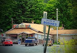
Bodines is a village in the township.
|
|

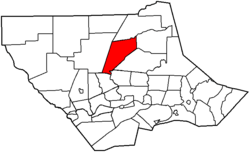
Map of Lycoming County, Pennsylvania highlighting Lewis Township
|
|

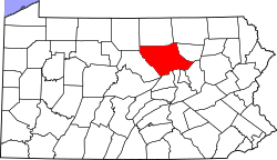
Map of Lycoming County, Pennsylvania=
|
|
| Country | United States |
| State | Pennsylvania |
| County | Lycoming |
| Settled | 1812 |
| Incorporated | 1835 |
| Area | |
| • Total | 37.44 sq mi (96.97 km2) |
| • Land | 37.09 sq mi (96.06 km2) |
| • Water | 0.35 sq mi (0.91 km2) |
| Elevation | 1,732 ft (528 m) |
| Population
(2010)
|
|
| • Total | 987 |
| • Estimate
(2016)
|
965 |
| • Density | 26.02/sq mi (10.05/km2) |
| Time zone | UTC-5 (Eastern Time Zone (North America)) |
| • Summer (DST) | UTC-4 (EDT) |
| FIPS code | 42-081-42944 |
| GNIS feature ID | 1216753 |
Lewis Township is a community located in Lycoming County, Pennsylvania, United States. It is a type of local government area called a township. In 2010, about 987 people lived here. It is also part of the larger Williamsport area.
Contents
History of Lewis Township
Lewis Township was created in 1835. It was formed from a part of Hepburn Township. The township was named after Ellis Lewis. He was a judge in the local court at that time. Later, in 1846, Lewis Township grew bigger. A part of Cascade Township was added to it. This happened because people in that area were cut off from the rest of Cascade Township.
Early Trails and Waterways
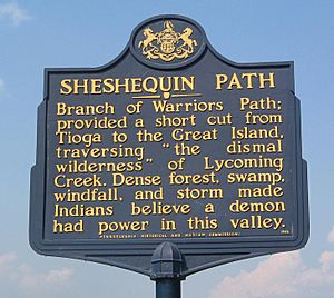
Two important features helped shape the early history of Lewis Township: Lycoming Creek and the Sheshequin Path. The Sheshequin Path was a major trail used by Native Americans. It connected two villages: "French Margaret's Town" (which is now part of Williamsport) and "Sheshequin" (now Ulster Township). This path was a shortcut between two main branches of the Susquehanna River. Early settlers also used it.
Lycoming Creek starts north of Lewis Township. It was like a natural highway during Pennsylvania's early days. Explorers and Native Americans used canoes to travel down the creek. This was much faster than walking. In 1737, a guide named Conrad Weiser led missionaries along the creek and path. They were going to Onondaga, the capital of the Iroquois Confederacy.
During the American Revolution, the creek and path were used by warriors. In 1778, Colonel Thomas Hartley led his soldiers up the Sheshequin Path. This expedition helped open up the Pennsylvania frontier. As Hartley's men passed through Lewis Township, they made the Sheshequin Path wider. This wider path made it easier for people to settle in the area after the Revolution.
First Settlers and Growth
Lewis Township was mostly empty until after the Revolutionary War. A person named A.M. Slack is thought to be the first permanent settler. He built a cabin and cleared land where the village of Bodines is today.
The village of Trout Run started when the Williamson Road was being built. This road went from Williamsport to Painted Post, New York. It helped open up north-central Pennsylvania for settlement. Charles Williamson, who built the road, set up a supply station at Trout Run.
Most of Lewis Township has steep hills. These hills were formed by streams flowing into the West Branch Susquehanna River. Because of the hills, the township has not developed much. Most people settled in the narrow valley along Lycoming Creek.
Around 1800, James Kyle owned land along Lycoming Creek. He had a farm with a house, barn, and even a grist mill. He advertised his farm for sale in 1810.
Prominent Families
Kyle's farm was later sold to Robert Allen. Robert and his family became important early settlers. Robert Allen was born in 1797. His family moved to land along Lycoming Creek. Robert sold his share of the family farm and bought James Kyle's land.
Robert Allen and his wife, Mary Ann Hews, improved the farm. They also ran an inn that was busy with travelers on the Williamson Road. Robert Allen was also a surveyor and civil engineer. He worked for the United States government in places like Michigan.
Mary Ann Hews' parents, Henry and Martha Hews, had moved to Pennsylvania from England. They struggled at first but later established successful farms. They eventually settled near Trout Run, where Mary Ann met Robert Allen.
Lewis Township has not changed much over the years. The number of people living there in 2010 was almost the same as in 1890. U.S. Route 15 now follows the old Williamson Road. This highway is part of the Interstate 99 project.
The Bridge in Lewis Township was added to the National Register of Historic Places in 1988. This means it is an important historical site.
Geography of Lewis Township
Lewis Township is located in the north-central part of Lycoming County. It shares borders with several other townships. To the west is Cogan House Township. To the north is McIntyre Township. Cascade Township is to the northeast. Gamble Township is to the southeast. At the very south corner is Hepburn Township. And to the southwest is Lycoming Township.
U.S. Route 15, also known as the Appalachian Thruway, goes through the township. It follows the valley of Lycoming Creek in the south. Then it turns up the side valley of Trout Run to the northwest. US-15 goes south about 15 miles to Williamsport, which is the main town in Lycoming County. It goes north about 35 miles to Mansfield. Pennsylvania Route 14 also starts from Trout Run and goes northeast about 25 miles to Canton.
The township covers about 37.44 square miles (96.97 square kilometers). Most of this area is land, about 37.09 square miles (96.06 square kilometers). A small part, about 0.35 square miles (0.91 square kilometers), is water. Lycoming Creek flows through the entire township from northeast to southwest. It eventually reaches the West Branch Susquehanna River in Williamsport. The land on both sides of the creek is part of the Allegheny Plateau. These areas rise high, about 1,200 to 1,400 feet above the valley floor.
Population and People
| Historical population | |||
|---|---|---|---|
| Census | Pop. | %± | |
| 2010 | 987 | — | |
| 2016 (est.) | 965 | −2.2% | |
| U.S. Decennial Census | |||
In 2000, there were 1,139 people living in Lewis Township. There were 451 households, which are groups of people living together. About 304 of these were families. The population density was about 30 people per square mile.
Most of the people living in the township were White (98.68%). A small number were African American (0.35%), Native American (0.09%), or Asian (0.09%). About 0.79% of the population were from two or more races.
In 2000, about 29.9% of households had children under 18 living with them. About 53.0% were married couples. The average household had 2.53 people, and the average family had 3.00 people.
The population was spread out by age. About 24.7% were under 18 years old. About 11.9% were 65 years or older. The average age was 38 years.
See also
 In Spanish: Municipio de Lewis (condado de Lycoming) para niños


