
Tully Mountain facts for kids
Quick facts for kids Tully Mountain |
|
|---|---|

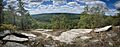
Southeast View from Tully Mountain
|
|
| Highest point | |
| Elevation | 1,163 ft (354 m) |
| Prominence | 499 ft (152 m) |
| Geography | |
| Location | Orange, Massachusetts |
| Parent range | Central Massachusetts highlands |
| Geology | |
| Age of rock | 200 million years |
| Mountain type | Metamorphic rock; monadnock |
| Climbing | |
| Easiest route | Tully Trail |
Tully Mountain is a cool mountain in north central Massachusetts. It stands about 1,163 feet (354 meters) tall. This mountain is a special type of landform called a monadnock. A monadnock is a hill or mountain that stands out all alone in a flat area.
Tully Mountain is part of the Tully Mountain Wilderness Management Area. From its top, you can see amazing views of the Millers River valley, Mount Monadnock, and Mount Wachusett. A long trail, the Tully Trail, which is about 22 miles (35 km) long, goes right over the mountain.
Did you know there's another Tully Mountain in Ireland? It's almost the same height, at 1,168 feet (356 meters)!
Water from Tully Mountain flows into the Tully River. From there, it goes into the Millers River, then to the Connecticut River, and finally reaches Long Island Sound.
Contents
Exploring Tully Mountain's Views
The top of Tully Mountain is mostly covered with trees. But there are two main rocky spots. One faces east, and the other faces west. These rocky areas are what make Tully Mountain easy to spot from nearby towns.
The East Viewpoint
The eastern rocky area is the most popular spot. Even though the very highest point of the mountain is wooded, this eastern ledge is where most people go for views. From here, you can see many distant mountains and towns.
- Mount Monadnock: This famous mountain in Jaffrey, NH, is about 16 miles northeast.
- Mount Wachusett: This is the tallest mountain you can see to the southeast, about 22 miles away.
- Other Mountains: On a clear day, you might spot Mount Sunapee, Mount Kearsarge, and Mount Cardigan.
- Local Sights: You can also see the church steeple in Royalston, MA, and three bodies of water: Tully Lake, Packard Pond, and Tully Pond.
If you have strong binoculars or a spotting scope, you might even see the distant Quabbin Reservoir Observation Tower, which is 24 miles south! You can also see parts of the town of Athol, Massachusetts, with its old buildings and church steeples. Looking north, you might even see people on top of Mount Monadnock!
The West Viewpoint: Thatcher Ledges
On the western side of Tully Mountain, there's another open granite area called Tully Ledges, or "Thatcher Ledges." It was found by a local person in 1968. This spot is bigger than the eastern viewpoint but is not as well-known.
You can find Thatcher Ledges by following a less-marked path from the cemetery trail. From here, you can see homes in North Orange and some mountains to the west. It's a great place for quiet time, watching nature, or having a picnic.
Safety at Thatcher Ledges
The granite at Thatcher Ledges can be slippery, especially when wet. It's important to be very careful to avoid falling. Hiking here after rain or when there's ice is not a good idea.
Hiking Tully Mountain
There are a few ways to hike up Tully Mountain. The trails are marked with blue and yellow blazes, but there aren't big trailhead signs. There's no fee to use the area. A sign at the parking area says no camping is allowed.
Popular Routes
- Cemetery Route: This path starts near the Tully Cemetery.
- Tully Brook Route: This route begins from a small dirt parking area off Tully Road. It follows a flat path around the mountain before going uphill.
- Mountain Road Route: This is often the easiest way up. It starts from a parking area at the eastern base of the mountain. You can take a slow, winding path or a steeper, faster path that connects to the Cemetery Route.
The slow ascent trail from the Mountain Road parking lot is about 0.9 miles long. It winds along an old stone wall and through a forest. The parking lot is at 709 feet, and you gain about 422 feet in height to reach the eastern viewpoint.
It usually takes about 20-30 minutes to hike one-way to the main viewpoint. This makes Tully Mountain a popular spot for hikers of all ages, including families and teenagers.
Little Tully Mountain
Tully Mountain actually has a smaller "twin peak" to its south, which is about 856 feet tall. It's sometimes called Little Tully Mountain. You can see Little Tully Mountain clearly from Tully Mountain, but it's not often climbed because it's covered in trees.
Images for kids
-

Tully Mountain from Tully Lake
-
Westerly View via Thatcher Ledges

