
Udhampur facts for kids
Quick facts for kids
Udhampur
|
|
|---|---|
|
City
|
|

Krimchi Temples
|
|

Udhampur
Location in Jammu and Kashmir

Udhampur
Location in India
|
|
| Country | |
| Union Territory | Jammu and Kashmir |
| District | Udhampur |
| Founded by | Raja Udham Singh |
| Named for | Raja Udham Singh |
| Government | |
| • Body | Udhampur Municipal Committee |
| Area | |
| • Total | 30.42 km2 (11.75 sq mi) |
| Elevation | 755 m (2,477 ft) |
| Population
(2011)
|
|
| • Total | 91,366 |
| • Density | 3,003.5/km2 (7,779.0/sq mi) |
| Demonym(s) | Udhampuri, Udhampuria, Udhampuriya |
| Languages | |
| • Official | Dogri, Hindi, Urdu, Kashmiri, English |
| Time zone | UTC+5:30 (IST) |
| PIN |
182101 (Udhampur)
|
| Telephone code | 91-1992 |
| Vehicle registration | JK-14 |
Udhampur is a city in the union territory of Jammu and Kashmir, India. It is the main city of the Udhampur District. The city is named after Raja Udham Singh, who was a local ruler.
Udhampur is an important place for the Indian Army. It is home to the Northern Command headquarters. The Indian Air Force also has a base here. The city is a key stop for the armed forces traveling between Jammu and Srinagar. This travel happens on National Highway 44.
Many interesting places are near Udhampur for visitors. These include Patnitop, Panchari Landhar, and the Chenani Nashri Tunnel.
Contents
Exploring Udhampur's Landscape
Udhampur district is in the Shivalik Hills, which are part of the Himalayas. This means the area is mostly mountainous. Higher parts of the district get snow in winter. Places like Patnitop and Sudhmahadev are known for this. The city of Udhampur itself is in a flatter area. It sits at about 756 meters (2,480 feet) above sea level.
How Udhampur is Governed
The city of Udhampur is managed by the Udhampur Municipal Committee. This committee helps run the city and has 22 different areas called municipal wards.
Udhampur's Climate and Weather
Udhampur has a subtropical climate. This means it has hot summers and cool winters. Summer temperatures can go above 40 degrees Celsius. In winter, temperatures can drop below freezing. The city gets about 130 centimeters of rain each year. Most of this rain falls during the monsoon season and in winter.
Central Udhampur does not often get snow. However, areas outside the city sometimes do. In recent years, there has been more snowfall. For example, in 2011, about 15 centimeters of snow fell. Heavy hailstorms can also happen in February and March.
| Climate data for Udhampur | |||||||||||||
|---|---|---|---|---|---|---|---|---|---|---|---|---|---|
| Month | Jan | Feb | Mar | Apr | May | Jun | Jul | Aug | Sep | Oct | Nov | Dec | Year |
| Record high °C (°F) | 24 (75) |
29 (84) |
33 (91) |
39 (102) |
40.5 (104.9) |
40.9 (105.6) |
41 (106) |
38 (100) |
32 (90) |
31 (88) |
29 (84) |
25 (77) |
41 (106) |
| Mean daily maximum °C (°F) | 18.8 (65.8) |
21.9 (71.4) |
26.6 (79.9) |
32.9 (91.2) |
38.3 (100.9) |
40.6 (105.1) |
35.5 (95.9) |
33.7 (92.7) |
33.6 (92.5) |
31.7 (89.1) |
26.8 (80.2) |
21.1 (70.0) |
30.1 (86.2) |
| Mean daily minimum °C (°F) | 1.2 (34.2) |
9.7 (49.5) |
13.6 (56.5) |
19.0 (66.2) |
24.4 (75.9) |
26.8 (80.2) |
24.5 (76.1) |
24.0 (75.2) |
23.0 (73.4) |
18.4 (65.1) |
12.6 (54.7) |
8.5 (47.3) |
17.7 (63.9) |
| Record low °C (°F) | −4.4 (24.1) |
−3 (27) |
3 (37) |
6 (43) |
7 (45) |
13 (55) |
13 (55) |
8 (46) |
12 (54) |
4 (39) |
2 (36) |
−3 (27) |
−4.4 (24.1) |
| Average rainfall mm (inches) | 50.0 (1.97) |
46.4 (1.83) |
53.2 (2.09) |
26.3 (1.04) |
16.0 (0.63) |
51.8 (2.04) |
283.4 (11.16) |
644.5 (25.37) |
123.9 (4.88) |
38.1 (1.50) |
11.9 (0.47) |
42.2 (1.66) |
1,387.7 (54.63) |
| Source: BBC Weather | |||||||||||||
Farming in Udhampur
Farming is very important to the people of Jammu & Kashmir. More than 80% of people here rely on agriculture. The main food crops grown are wheat, paddy (rice), and maize (corn). Other crops like barley are also grown in some areas. The climate in this region is good for growing fruits and vegetables. This is called horticulture.
Udhampur's Population and People
In 2011, the population of Udhampur's urban area was 91,366 people. A large number of men live in Udhampur. This is because many army personnel are stationed in the city. Most people in Udhampur can read and write. The main religion in the city is Hinduism.
|
||||||||||||||||||||||||||||||||||||
Learning in Udhampur: Schools and Colleges
Udhampur has many places for students to learn. There are several colleges and schools in the city.
Colleges for Higher Education
- GOVERNMENT DEGREE COLLEGE (BOYS) UDHAMPUR
- GOVERNMENT COLLEGE FOR WOMAN UDHAMPUR
- GOVT. DEGREE COLLEGE DUDU BASANTGARH
- GOVT. DEGREE COLLEGE, CHENANI
- GOVT. DEGREE COLLEGE MAJALTA UDHAMPUR
- GOVT DEGREE COLLEGE RAMNAGAR
- GOVT. DEGREE COLLEGE NEELI NALLAH, UDHAMPUR
- Bhartiya College of Education, Udhampur
- Bhim Singh College of Education, Udhampur
- Kalra College of Education
- Shivalik College of Education, Udhampur
- Bhaskar College
- Kalra College of Education, Patnitop
Schools for Young Learners
- Brahmrishi Bawra Shanti Vidya Peeth School Udhampur
- Army Public School Udhampur
- Dhruva Army Pre Primary School
- Army Public School Dhar Road
- Eagle Army Pre Primary School
- Kendriya Vidyalaya-1
- Kendriya Vidyalaya-2
- Delhi Public School
- Jawahar Navodaya Vidyalaya
- Happy Model Higher Secondary School
- Government Boys Higher Secondary School
- Government Girls Higher Secondary School
- Common Public School
- Vijay Higher Secondary School
- Prashant Public High. Sec School Udhampur
- Bhartiya Vidya Mandir School
- a.o.c. higher secondary school subash nagar udhampur
- jk public school
- HIMALAYAN MODEL ACADEMY
Getting Around Udhampur: Transport Options
Udhampur has good ways to travel by road and rail.
Road Travel
Udhampur is on National Highway NH-44. This is the only highway that connects Srinagar to the rest of India. Buses are a common way to travel to and from Udhampur. You can find frequent buses to the Kashmir Valley and Jammu. Taxis are also available. Minibuses help people travel within the city.
Train Travel
Udhampur is connected by train to Jammu. Jammu is the winter capital of Jammu and Kashmir. The first train to run on this line was the Uttar Sampark Kranti Express from New Delhi in 2005. Many long-distance trains start from Udhampur railway station or pass through it. These trains connect Udhampur to other parts of India. There are also local trains between Jammu and Udhampur.
There is a big project to connect Udhampur to the Kashmir valley by train. The railway line has already reached Katra. The next step is to lay tracks from Katra to Banihal. This will complete the Jammu–Baramulla line.
Air Travel
The Udhampur Air Force Station is in Udhampur. However, it is only for the Indian Air Force and not for regular people. The closest airport for civilians is Jammu Airport.
Gallery
-
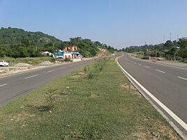
Udhampur-Jammu highway
-
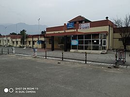
Udhampur railway station
-
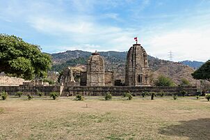
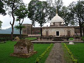
Krimchi temples
-
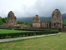
Kirmachi Temples
-
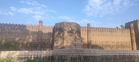
Ramnagar Fort
-
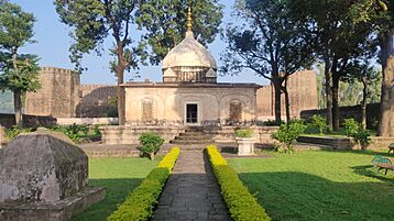
Samadhi of Queen of Raja Suchet Singh
-
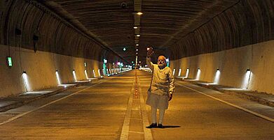
Dr. Syama Prasad Mookerjee Tunnel also known as Chenani Nashri Tunnel
-
Ramnagar Fort


See also
 In Spanish: Udhampur para niños
