Ukiah, Oregon facts for kids
Quick facts for kids
Ukiah, Oregon
|
|
|---|---|

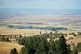
Ukiah skyline
|
|

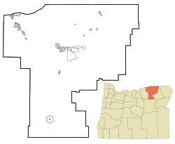
Location in Oregon
|
|
| Country | United States |
| State | Oregon |
| County | Umatilla |
| Incorporated | 1969 |
| Area | |
| • Total | 0.24 sq mi (0.62 km2) |
| • Land | 0.24 sq mi (0.62 km2) |
| • Water | 0.00 sq mi (0.00 km2) |
| Elevation | 3,356 ft (1,023 m) |
| Population
(2020)
|
|
| • Total | 159 |
| • Density | 668.07/sq mi (257.67/km2) |
| Time zone | UTC-8 (Pacific) |
| • Summer (DST) | UTC-7 (Pacific) |
| ZIP code |
97880
|
| Area code(s) | 541 |
| FIPS code | 41-75550 |
| GNIS feature ID | 2412126 |
| Website | www.cityofukiahoregon.com |
Ukiah is a small city in Umatilla County, Oregon, USA. In 2020, about 159 people lived there. It is part of the Hermiston-Pendleton Micropolitan Statistical Area, which includes several nearby towns. An early settler named the city after Ukiah, California, a town they knew.
Ukiah is famous for being one of the coldest places in Oregon. On February 9, 1933, the temperature dropped to -54°F (-48°C). This happened during a very cold period across North America. Another Oregon town, Seneca, also reached -54°F the next day. Because Seneca's record was more recent, the National Weather Service officially gives Seneca the record.
Contents
History of Ukiah
Ukiah was first planned out in August 1890 by the Camas Land Company. A person named E. B. Gambee, who moved from Ukiah, California, suggested the name for the new town. The first post office in Ukiah opened in September 1890. DeWitt C. Whiting was the first postmaster, which means he was in charge of the post office.
Exploring Ukiah's Geography
Ukiah is located in northeastern Oregon. It sits where two main roads meet: U.S. Route 395 and Oregon Route 244. The city is about 45 miles (72 km) south of Pendleton by road. It is also about 50 miles (80 km) southwest of La Grande.
The city is built along Camas Creek. This creek flows west from the Blue Mountains. It also runs through the Umatilla National Forest just east of Ukiah. Camas Creek eventually flows into the North Fork John Day River.
According to the United States Census Bureau, Ukiah covers a total area of 0.24 square miles (0.62 square kilometers). All of this area is land.
Ukiah's Population and People
| Historical population | |||
|---|---|---|---|
| Census | Pop. | %± | |
| 1980 | 249 | — | |
| 1990 | 250 | 0.4% | |
| 2000 | 255 | 2.0% | |
| 2010 | 186 | −27.1% | |
| 2020 | 159 | −14.5% | |
| U.S. Decennial Census | |||
Ukiah's Population in 2010
In 2010, the city of Ukiah had 186 people living there. There were 79 households and 48 families. The city had about 775 people per square mile (299 people per square kilometer). There were 122 homes in total.
Most of the people in Ukiah were White (90.3%). There were also Native American (2.2%), Asian (3.2%), and other races. About 4.3% of the population was Hispanic or Latino.
About 25.3% of households had children under 18. Almost half (46.8%) were married couples. Some households had a single parent, either a mother (7.6%) or a father (6.3%). About 39.2% of households were not families.
The average age of people in Ukiah was 45 years old. About 28% of residents were under 18. About 21% were 65 years or older. The city had slightly more males (53.2%) than females (46.8%).
Education in Ukiah
Ukiah is part of the Ukiah School District 80. In 1969, Ukiah's high school had only 24 students. This made it one of the smallest high schools in Oregon at that time.
Ukiah's Climate
Ukiah has a type of climate called a dry-summer humid continental climate. This means it has warm, but not very hot, and dry summers. No average monthly temperature goes above 62°F (17°C).
| Climate data for Ukiah | |||||||||||||
|---|---|---|---|---|---|---|---|---|---|---|---|---|---|
| Month | Jan | Feb | Mar | Apr | May | Jun | Jul | Aug | Sep | Oct | Nov | Dec | Year |
| Record high °F (°C) | 60 (16) |
70 (21) |
75 (24) |
87 (31) |
93 (34) |
100 (38) |
106 (41) |
110 (43) |
104 (40) |
92 (33) |
76 (24) |
68 (20) |
110 (43) |
| Mean daily maximum °F (°C) | 36.6 (2.6) |
43.1 (6.2) |
49.0 (9.4) |
56.7 (13.7) |
63.9 (17.7) |
72.5 (22.5) |
82.2 (27.9) |
82.4 (28.0) |
74.1 (23.4) |
63.0 (17.2) |
46.8 (8.2) |
37.9 (3.3) |
59.0 (15.0) |
| Mean daily minimum °F (°C) | 14.4 (−9.8) |
18.8 (−7.3) |
23.5 (−4.7) |
27.6 (−2.4) |
32.9 (0.5) |
37.9 (3.3) |
39.7 (4.3) |
38.9 (3.8) |
31.6 (−0.2) |
25.8 (−3.4) |
22.5 (−5.3) |
16.9 (−8.4) |
27.5 (−2.5) |
| Record low °F (°C) | −46 (−43) |
−54 (−48) |
−17 (−27) |
9 (−13) |
12 (−11) |
17 (−8) |
21 (−6) |
20 (−7) |
8 (−13) |
−2 (−19) |
−32 (−36) |
−38 (−39) |
−54 (−48) |
| Average precipitation inches (mm) | 1.92 (49) |
1.5 (38) |
1.43 (36) |
1.41 (36) |
1.73 (44) |
1.67 (42) |
0.54 (14) |
0.67 (17) |
0.84 (21) |
1.34 (34) |
1.92 (49) |
2.14 (54) |
17.1 (430) |
| Average snowfall inches (cm) | 11.4 (29) |
7.3 (19) |
4.2 (11) |
1.2 (3.0) |
0.1 (0.25) |
0 (0) |
0 (0) |
0 (0) |
0.1 (0.25) |
0.3 (0.76) |
4.8 (12) |
8.8 (22) |
38.4 (98) |
| Average precipitation days | 12 | 10 | 11 | 10 | 9 | 8 | 3 | 4 | 5 | 7 | 11 | 12 | 102 |
See also
 In Spanish: Ukiah (Oregón) para niños


