Undalya, South Australia facts for kids
Quick facts for kids UndalyaSouth Australia |
|||||||||||||||
|---|---|---|---|---|---|---|---|---|---|---|---|---|---|---|---|

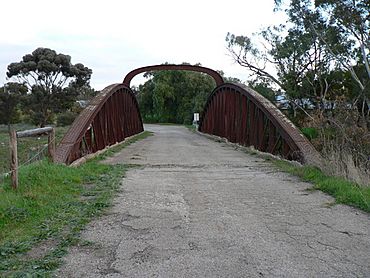
Basket Bridge, Undalya, circa 2009
|
|||||||||||||||
| Established | 1859 | ||||||||||||||
| Postcode(s) | 5451 | ||||||||||||||
| Time zone | ACST (UTC+9:30) | ||||||||||||||
| • Summer (DST) | ACDT (UTC+10:30) | ||||||||||||||
| LGA(s) | District Council of Clare and Gilbert Valleys | ||||||||||||||
| State electorate(s) | Frome | ||||||||||||||
| Federal Division(s) | Grey | ||||||||||||||
|
|||||||||||||||
Undalya (Postcode: 5451) is a small country town in South Australia. It sits on the southern edge of the Clare Valley. You can find it on the Horrocks Highway, about halfway between the towns of Auburn and Rhynie. Undalya is located where the River Wakefield meets Pine Creek. The town was officially named Undalya in 1859.
Contents
What Does Undalya Mean?
The name Undalya comes from the local Aboriginal people. It means "water holes." The area around the town was called Kercoonda, which means "camp near water." In the early days, many Aboriginal people lived in this region.
Exploring Undalya's Past
A famous explorer named Edward John Eyre once camped at Undalya. He noted how much water was in the River Wakefield. He also mentioned the blue limestone found nearby.
The Famous Basket Bridge
The most well-known landmark in Undalya is its bridge over the River Wakefield. It was built in 1855. People call it by three different names: Basket Bridge, Cradle Bridge, or Coathanger Bridge. This bridge has survived many floods. For a time, it was the biggest one-span bridge in South Australia. A new bridge was built in the 1950s, so the old bridge is now mostly used by local residents.
Early Churches and Schools
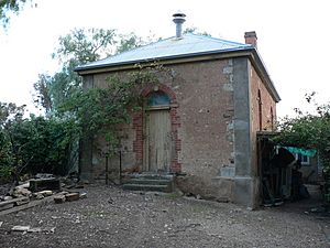
In 1859, a local farmer sold some land for a Bible Christian Church. The church was built that same year. A school started inside the church in 1860. Both the church and school were open for almost 100 years. Today, this building is a private home.
In 1866, the Roman Catholic Church of St. Patrick was built. It was located on a hill south of the village. The Jesuit Fathers from Sevenhill helped build it. This church closed in 1915 and was later taken down. There was a graveyard next to the church, which is still used as a cemetery today.
Wool Industry in Undalya
In the 1800s, one of the biggest local businesses was wool-scouring. This means washing wool in the River Wakefield. George Henry Michell moved to Undalya in 1870. He had learned how to wash wool. He convinced local farmers to sell their wool to him. The wool was cleaned in the river. Then, it was sent to Adelaide and shipped to London for sale. His business grew very quickly. In 1896, he had to move his operations closer to Adelaide.
Today, Michell is a large international company. It is still run by George Henry Michell's family. Their factory is now in Salisbury South. The old Michell family home in Undalya is still standing. It is now used as an animal shelter.
Life in the Old Days
From the mid-1800s to the early 1900s, Undalya was a busy country village. Newspapers from that time reported on many events. There were ploughing matches and horse racing. The village even had a local hotel.
Today, Undalya is a quiet place. It is mostly a few houses around the old bridge.
How Undalya is Governed
Undalya is part of the District Council of Clare and Gilbert Valleys. For state government, it is in the State Electoral District of Frome. For the national government, it is in the Australian House of Representatives Division of Grey.
 | Sharif Bey |
 | Hale Woodruff |
 | Richmond Barthé |
 | Purvis Young |


