Underwood, Queensland facts for kids
Quick facts for kids UnderwoodLogan City, Queensland |
|||||||||||||||
|---|---|---|---|---|---|---|---|---|---|---|---|---|---|---|---|

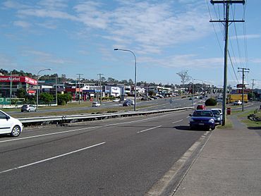
Logan Road, 2014
|
|||||||||||||||
| Population | 6,809 (2021 census) | ||||||||||||||
| • Density | 1,621/km2 (4,200/sq mi) | ||||||||||||||
| Postcode(s) | 4119 | ||||||||||||||
| Area | 4.2 km2 (1.6 sq mi) | ||||||||||||||
| Time zone | AEST (UTC+10:00) | ||||||||||||||
| Location |
|
||||||||||||||
| LGA(s) | Logan City | ||||||||||||||
| State electorate(s) | Waterford | ||||||||||||||
| Federal Division(s) | Rankin | ||||||||||||||
|
|||||||||||||||
Underwood is a cool suburb located in Logan City, Queensland, Australia. In 2021 census, about 6,809 people called Underwood home.
Contents
Where is Underwood?
Underwood is about 18 kilometers (11 miles) south-east of central Brisbane. The Logan Motorway forms one of its borders, and Compton Road marks its southern edge.
A Look at Underwood's Past
Underwood is on the traditional lands of the Yugarabul Indigenous Australian people. Towards the south-east, near Beenleigh, is the traditional country of the Bundjalung people.
The suburb gets its name from William Underwood. He was an early landowner in the area. William Underwood ran the Commercial Hotel from the early 1870s until 1895. This hotel was located near Beenleigh Road. Underwood officially became a suburb on August 11, 1975. It was once part of both Brisbane City Council and the old Shire of Albert. Then, in 1978, Logan City was created, and Underwood became part of it.
Who Lives in Underwood?
Let's look at how the population of Underwood has changed over time!
People in 2011
In 2011 census, Underwood had 5,328 people. Almost half were female (49.9%) and half were male (50.1%). The average age was 32 years old, which was younger than the national average of 37. Most people (59.6%) were born in Australia. Other common birthplaces included New Zealand (6.3%), China (2.3%), England (2.2%), South Africa (1.9%), and South Korea (1.8%). About 67.7% of people spoke only English at home. Other languages spoken included Mandarin (4.5%), Cantonese (3.0%), Korean (2.2%), Arabic (1.7%), and Hindi (1.4%).
People in 2016
By 2016 census, the population grew to 6,341 people. Females made up 50.5% and males 49.5%. The average age was 33 years, still younger than the national average of 38. The number of people born in Australia was 51.2%. Other top countries of birth were China (4.7%), India (4.5%), New Zealand (4.3%), South Korea (3%), and Taiwan (2.4%). English was spoken at home by 54.3% of people. Other languages included Mandarin (8.1%), Korean (3.7%), Cantonese (3.7%), Punjabi (3.5%), and Arabic (2.3%).
People in 2021
In 2021 census, Underwood had 6,809 residents. Females were 49.5% and males were 50.5%. The average age was 34 years, still younger than the national average of 38. About 50.7% of people were born in Australia. Other common birthplaces were India (6.6%), China (4.1%), South Korea (3.9%), New Zealand (3.6%), and Taiwan (2.1%). Half the people (50.0%) spoke only English at home. Other popular languages included Mandarin (7.8%), Punjabi (6.1%), Korean (4.9%), Cantonese (3.8%), and Hindi (2.4%).
Learning in Underwood
Underwood itself does not have any schools. However, there are several schools nearby.
Primary Schools Nearby
- Eight Mile Plains State School in Eight Mile Plains (north-west)
- Springwood Road State School in Rochedale South (north-east)
- Kuraby State School in Kuraby (west)
Secondary Schools Nearby
- Rochedale State High School in Rochedale (north)
- Springwood State High School in Springwood (east)
- Runcorn State High School in Runcorn (west)
Fun Things to Do
The Logan North branch Library is in Underwood. It opened in 2008 and is run by Logan City Council Libraries. You can find it at the corner of Sports Drive and Springwood Road. They even have free public WiFi!
Getting Around Underwood
You can easily reach Underwood by car using the Pacific Motorway (M1).
Public Transport Options
- Buses: Public transport is available through the Springwood Bus Station, which is part of the South East Busway.
- Trains: The closest train stations are:
* Kuraby Railway Station in the nearby suburb of Kuraby. * Trinder Park Railway Station in the nearby suburb of Woodridge.
 | James B. Knighten |
 | Azellia White |
 | Willa Brown |


